Automatic construction method and system for road network of open mine

An automatic construction and road network technology, applied in image data processing, instrumentation, 2D image generation, etc., can solve the problems of lack of road network topological relationship information, poor precision, frequent changes of mine road network, etc., to achieve automatic and accurate Construct and ensure safe effect

Active Publication Date: 2015-12-09
CHANGSHA DIGITAL MINE
View PDF3 Cites 12 Cited by
  • Summary
  • Abstract
  • Description
  • Claims
  • Application Information

AI Technical Summary

Problems solved by technology

With the application and development of informatization and intelligence in mines, the demand for automatic construction and rapid update of road networks in open-pit mines is increasingly urgent. Existing road network construction technologies for open-pit mines have problems such as low degree of automation, long cycle, high cost and precision. Inadequate problems, resulting in the dilemma that the construction of the open-air road network cannot keep up with the actual development and changes
[0003] The existing road network construction methods are mainly divided into two categories: one is the traditional surveying and mapping method, which has defects such as low degree of automation, long cycle, and high cost. At the same time, due to the continuous advancement of mining, the mine road network changes frequently and irregularly. However, this type of method cannot be effectively used in the actual production and application of open-pit mines; the other is the road network construction method based on GPS data collection. Many researchers have studied the automatic construction method of urban road networks on the basis of GPS data. And achieved certain results, but no one has studied the automatic construction of road networks for open-pit mines
[0004] Shi Wenhuan proposed a method for automatically generating road network raster digital maps based on GPS positioning. This method stores historical GPS data in the trajectory database, and obtains the road network through computer filtering and enhancement of the data in the trajectory database, which cannot meet the requirements of the open-pit mine road network. The requirement of real-time dynamic update, and at the same time, this method generates a raster digital map, which lacks road network topological relationship information, and cannot meet the needs of truck scheduling in open-pit mines; Zhang Jianqin proposed a road condition information generation method based on bus GPS trajectory data And Sun Dihua proposed a method of generating road network vector maps using GPS data of urban floating vehicles. These methods are only suitable for the automatic construction of urban road networks. In the method, either the bus station is used as a reference, or the urban road lines are relatively fixed As a premise, it cannot be applied to the complex situation of the road network of open-pit mines; Shi Wenzhong proposed a 3D road generation method based on airborne LIDAR and GIS collaboration, which mainly studies road point cloud clipping, viaduct road automatic layering and elevation within Interpolation, etc., the above-mentioned problems do not exist in open-pit mine roads, so this method cannot be applied
[0005] In view of the above phenomena, a fast and accurate automatic network construction method is urgently needed to solve the problem of automatic construction of road networks in open-pit mines

Method used


Image

  • Automatic construction method and system for road network of open mine
  • Automatic construction method and system for road network of open mine
  • Automatic construction method and system for road network of open mine

Examples


Embodiment Construction

[0075] In order to make the purpose, technical solutions and advantages of the embodiments of the present invention clearer, the technical solutions in the embodiments of the present invention will be clearly and completely described below in conjunction with the drawings in the embodiments of the present invention. Obviously, the described embodiments It is a part of embodiments of the present invention, but not all embodiments. Based on the embodiments of the present invention, all other embodiments obtained by persons of ordinary skill in the art without creative efforts fall within the protection scope of the present invention.

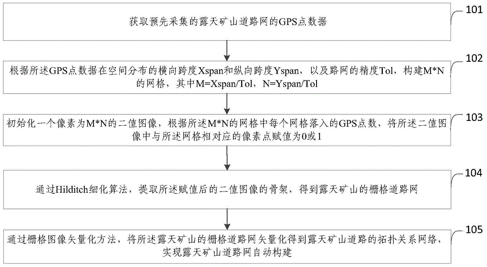
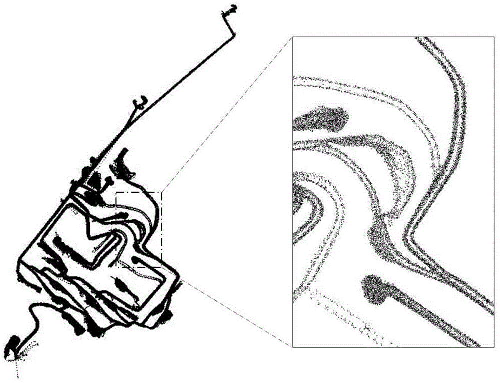
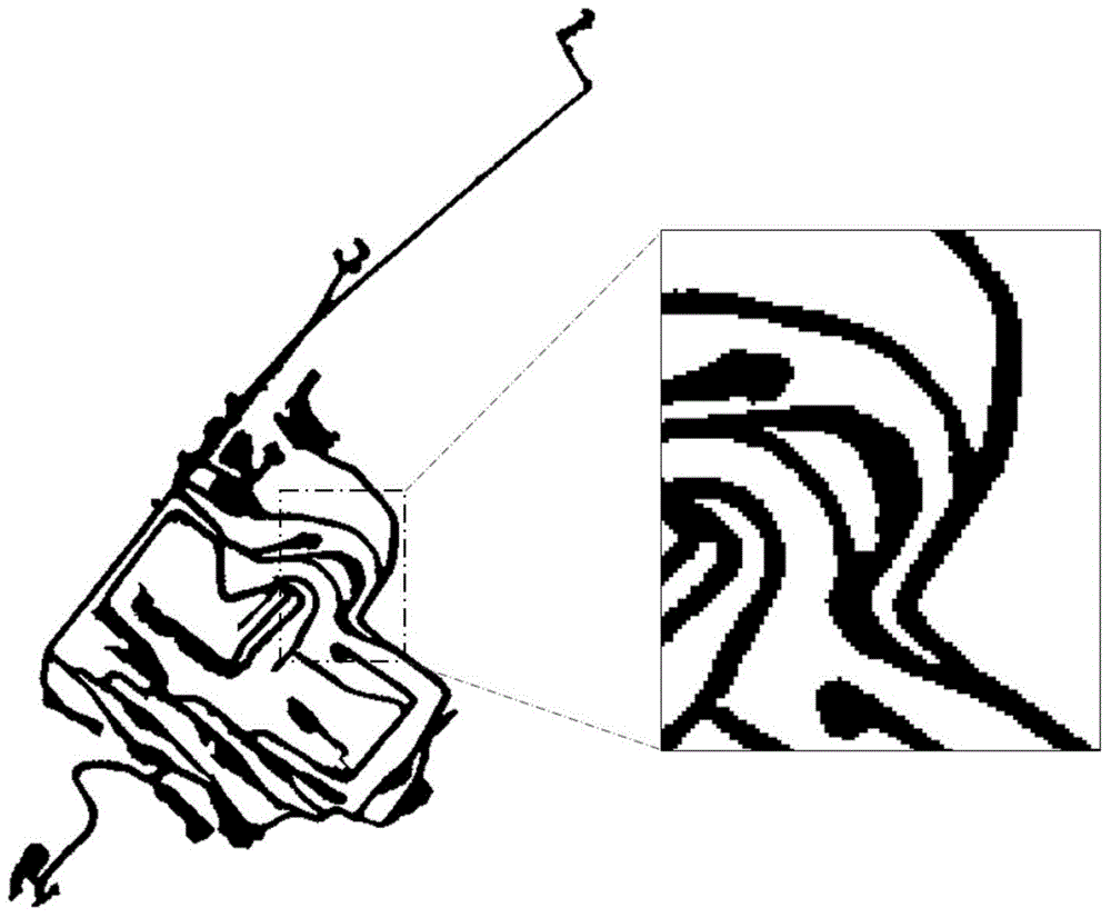
[0076] figure 1 It shows the flow chart of the method for automatically constructing the road network of open-pit mines provided by Embodiment 1 of the present invention, see figure 1 , the method for automatically constructing the open-pit mine road network provided by the embodiment of the present invention includes the following steps:

[007...


PUM


Abstract

The invention provides an automatic construction method and system for a road network of open mine. The method comprises: obtaining pre-acquired GPS point data of the road network of the open mine; according to a transverse span Xspan and a longitudinal span Yspan of the GPS data distributed in space and the precision Tol of the road network, constructing M*N grids; initializing a binary image with a pixel of M*N, and according to the number of GPS points located in each of the M*N grids, assigning a pixel point corresponding to the grid in the binary image with a value of 0 or 1; by using a Hilditch thinning algorithm, extracting a framework of the assigned binary image subjected to value assignment, and obtaining the grid road network of the open mine; and by using a grid image vectorization method, vectorizing the grid road network of the open mine to obtain a topological relationship network of an open mine road. The automatic construction method for the road network of the open mine can realize automatic construction of the road network of the open mine.

Description

technical field [0001] The invention relates to the field of road construction in open-pit mines, in particular to a method and system for automatically constructing road networks in open-pit mines. Background technique [0002] The open-pit mine road network is a road network that truly reflects the geographical location information of the open-pit mine roads and the topological relationship between the roads. It is the basis for the open-pit mine truck dispatching system and mining equipment operation monitoring and management. With the application and development of informatization and intelligence in mines, the demand for automatic construction and rapid update of road networks in open-pit mines is increasingly urgent. Existing road network construction technologies for open-pit mines have problems such as low degree of automation, long cycle, high cost and precision. Inadequate problems, resulting in the dilemma that the construction of the open-air road network cannot ...

Claims


Application Information

Patent Timeline
Patent Type & Authority Applications(China)
IPC IPC(8): G06T11/00G06Q10/04G06Q50/02
Inventor 王李管陈鑫毕林宋华强吕青海
Owner CHANGSHA DIGITAL MINE
Why Eureka
Try Eureka