Space-time integrated fusion method of remote sensing land surface temperature data

A technology of surface temperature and fusion method, which is applied in the direction of electrical digital data processing, special data processing applications, instruments, etc., can solve the problem of temporal and spatial discontinuity of remote sensing surface temperature data, achieve high practical value, easy implementation, and improve temporal and spatial resolution Effect

Inactive Publication Date: 2015-12-23
广西壮族自治区基础地理信息中心
View PDF6 Cites 22 Cited by
  • Summary
  • Abstract
  • Description
  • Claims
  • Application Information

AI Technical Summary

Problems solved by technology

[0006] The problem to be solved by the present invention is to provide a spatio-temporal integration fusion method of remote sensing surface temperature data in view of the technical limitations of the existing observation system and the temporal and spatial discontinuity of remote sensing surface temperature data

Method used


Image

  • Space-time integrated fusion method of remote sensing land surface temperature data
  • Space-time integrated fusion method of remote sensing land surface temperature data
  • Space-time integrated fusion method of remote sensing land surface temperature data

Examples


Embodiment Construction

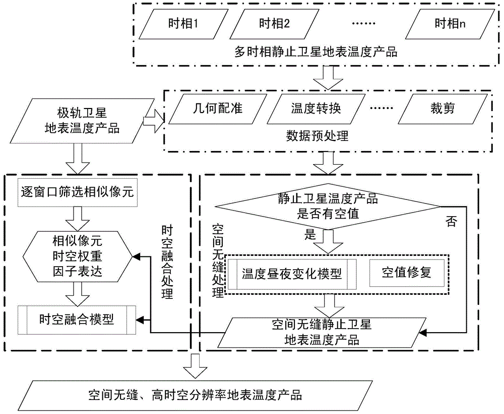
[0028] The technical solution of the present invention will be described in detail below in conjunction with the drawings and embodiments.

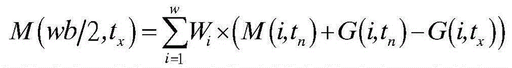
[0029] Suppose there is a spatially seamless high-spatial-resolution polar-orbiting satellite surface temperature data M and multi-temporal geostationary satellite surface temperature data Gt in the same region p (p=0,1,...n, and n>10). Further assume that in the time series t 0 , t 1 ...t n-1 , t nThere is a scene above where the surface temperature data G and the surface temperature data M of polar orbiting satellites correspond to each other in terms of acquisition time. Through the integration of time and space, Mt with seamless space and spatial resolution of the surface temperature data of polar orbiting satellites can be obtained. p (p=0,1,...n).

[0030] As shown in Figure 1, the embodiment process of the present invention can be divided into three stages:

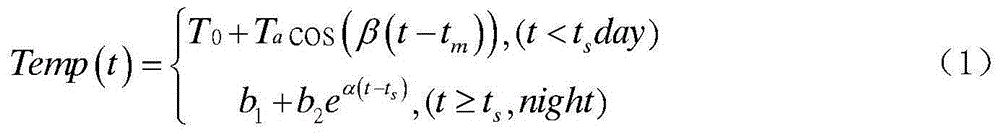
[0031] Phase 1: Preprocessing of surface temperature data

[0032]...


PUM


Abstract

The present invention relates to the quantitative remote sensing data processing technology, and discloses space-time integrated fusion method of remote sensing land surface temperature data. The method comprises first pre-processing the remote sensing land surface temperature data, then solving land surface temperature diurnal change model parameters by using multidate temperature data and corresponding time, thus to realize space seamlessness, screening similar picture elements window by window on polar orbit satellite land surface temperature image data, and in combination with weight factors such as time difference, scale difference, similarity difference and Euclidean distance composed by an multidate motionless satellite and the above model, commonly establishing a space-time integrated fusion model and solving a high temporal-spatial resolution land surface temperature dataset for generating space seamlessness. According to the method provided by the present invention, space-time complementary information of land surface temperature data of the polar orbit satellite and the multidate motionless satellite and diurnal change rules of motionless satellite land surface temperature are fully utilized, and no auxiliary data is required, such that the method is easy to realize, high in practical value and applicable to remote sensing land surface temperature data operational running with seamless space and time.

Description

technical field [0001] The invention relates to the technical field of quantitative remote sensing data processing, in particular to a spatiotemporal integration fusion method of remote sensing surface temperature data. Background technique [0002] Land Surface Temperature (LST, LandSurfaceTemperature) is an important parameter to study the exchange of matter and energy between the ground and the air, and is widely used in urban heat island effect, soil moisture estimation, forest fire monitoring, climate change and other fields. Satellite thermal infrared remote sensing is an important means to obtain surface temperature. However, the remote sensing observation system needs to make a trade-off between spatial resolution and time resolution. It is difficult to obtain temperature data with high temporal and high spatial resolution at the same time, which greatly limits breadth and depth of its application. For example, the time resolution of geostationary satellite surface ...

Claims


Application Information

Patent Timeline
Patent Type & Authority Applications(China)
IPC IPC(8): G06F19/00
Inventor 吴鹏海沈焕锋刘紫涵曾超邹照旭
Owner 广西壮族自治区基础地理信息中心
Why Eureka
Try Eureka