Building seismic damage analysis method

An analysis method and building technology, applied to building components, earthquake resistance, instruments, etc., can solve the problems that the damage state cannot be truly reflected, the remote sensing earthquake damage classification and grading standards are not consistent with the on-site investigation, and the difficulty of using it

Inactive Publication Date: 2016-01-13
NAT INST OF NATURAL HAZARDS MINISTRY OF EMERGENCY MANAGEMENT OF CHINA
View PDF3 Cites 16 Cited by
  • Summary
  • Abstract
  • Description
  • Claims
  • Application Information

AI Technical Summary

Problems solved by technology

Compared with the traditional earthquake damage site investigation, remote sensing earthquake damage assessment has the characteristics of fast, efficient, and safe, but it also has the following shortcomings: (1) Traditional remote sensing images are based on two-dimensional planes, and only record information on the top and a small amount of side surfaces of buildings , which cannot truly reflect its damage state; (2) Most of the analysis objects are not buildings, but grids or...

Method used


Image

  • Building seismic damage analysis method
  • Building seismic damage analysis method
  • Building seismic damage analysis method

Examples


Embodiment

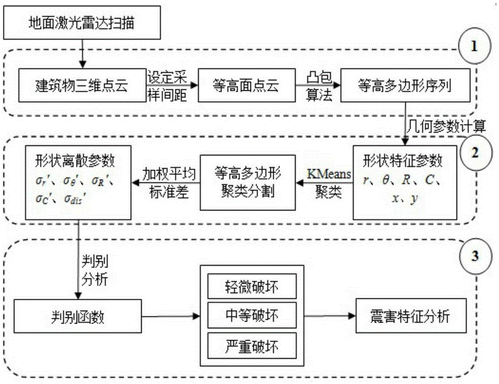
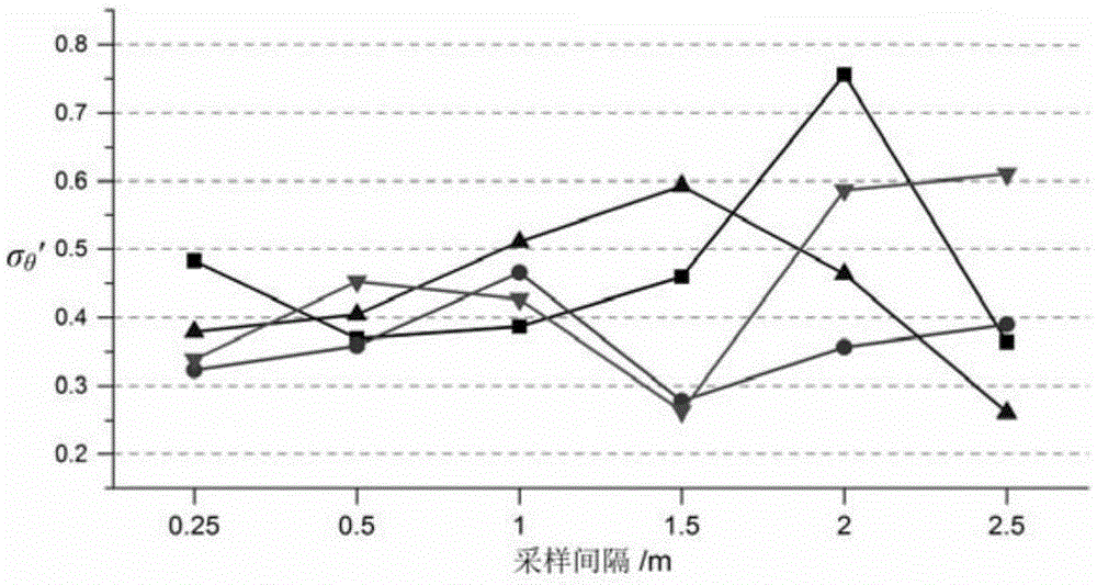
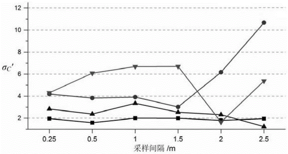
[0184] In this method, experiments were carried out on the 3D laser point cloud data acquired after the Wenchuan Earthquake. A total of 21 buildings were selected as sample data, including 12 buildings in Beichuan County, 6 buildings in Hanwang Town, 1 building in Dujiangyan City, and 1 building in Beijing. The 3D point cloud data of the above-mentioned buildings were collected and processed by a 3D laser scanner, and the degree of damage and the number of blocks were recorded during the on-site investigation. Table 1 is the basic information of the collected building samples, which will be used for subsequent analysis Provide auxiliary information. In order to analyze the influence of different sampling intervals of buildings on the shape characteristic parameters and seismic damage analysis results, six groups of different sampling intervals i were set in the experiment, which were 0.25m, 0.5m, 1m, 1.5m, 2m and 2.5m.

[0185] 1. Results and analysis; for 21 buildings, the sh...


PUM


Abstract

The invention discloses a building seismic damage analysis method, and relates to the field of seismic damage assessment. The method comprises the following steps of: setting a contour sampling interval, extracting a point cloud set of different height of a building, then, obtaining a contour section profile line through a convex hull algorithm, and converting three-dimensional point cloud of the building into a two-dimensional contour polygon sequence; extracting shape discrete parameters of the building; and calculating standard deviation of building shape parameters, and through a Fisher discriminant analysis, performing statistics on the standard deviation obtained in a step S22 or a step S23, thereby obtaining a discrimination function corresponding to three types of degree of damage of the building. According to the invention, edge extraction, shape clustering and discriminant analysis are fused, and problems in building contour polygon sequence extraction, shape discrete parameter calculation, irregular building block segmentation and damage analysis are solved effectively.

Description

technical field [0001] The invention relates to the field of earthquake disaster assessment, in particular to a building earthquake damage analysis method. Background technique [0002] With the continuous development of space technology and computer technology, different types of remote sensing data, such as optical images, radar images, etc., are applied to the evaluation and analysis of building damage. Compared with the traditional earthquake damage site investigation, remote sensing earthquake damage assessment has the characteristics of fast, efficient, and safe, but it also has the following shortcomings: (1) Traditional remote sensing images are based on two-dimensional planes, and only record information on the top and a small amount of side surfaces of buildings , which cannot truly reflect its damage state; (2) Most of the analysis objects are not buildings, but grids or irregular planes; (3) The remote sensing earthquake damage classification and grading standard...

Claims


Application Information

Patent Timeline
IPC IPC(8): G06F19/00E04B1/98
Inventor 焦其松张景发蒋洪波李强王珊珊
Owner NAT INST OF NATURAL HAZARDS MINISTRY OF EMERGENCY MANAGEMENT OF CHINA
Why Eureka
Try Eureka