Satellite remote sensing image cloud amount calculation method on the basis of random forest

A technology of satellite remote sensing images and calculation methods, which is applied in the field of quality inspection of satellite remote sensing images, and can solve problems such as lack of general system methods, individual texture or brightness or frequency characteristics, poor versatility, etc.

A technology of satellite remote sensing images and calculation methods, which is applied in the field of quality inspection of satellite remote sensing images, and can solve problems such as lack of general system methods, individual texture or brightness or frequency characteristics, poor versatility, etc.

CN105260729AActive Publication Date: 2016-01-20经通空间技术(河源)有限公司

Image

  • Satellite remote sensing image cloud amount calculation method on the basis of random forest
  • Satellite remote sensing image cloud amount calculation method on the basis of random forest
  • Satellite remote sensing image cloud amount calculation method on the basis of random forest

Examples


Embodiment Construction

[0082] In order to facilitate those of ordinary skill in the art to understand and implement the present invention, the present invention will be described in further detail below in conjunction with the accompanying drawings and embodiments. The implementation examples described here are only used to illustrate and explain the present invention, but do not limit the scope of the present invention. protected range.

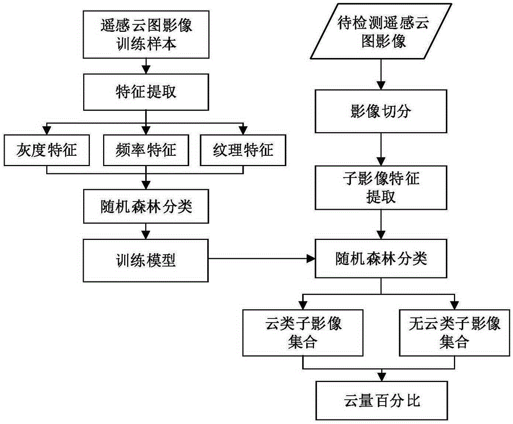
[0083] The present invention takes the panchromatic image data of Ziyuan No. 3 satellite as an example, please refer to figure 1 , a kind of satellite remote sensing image cloud amount calculation method based on random forest provided by the invention, comprises the following steps:

[0084] Step 1: sample acquisition;

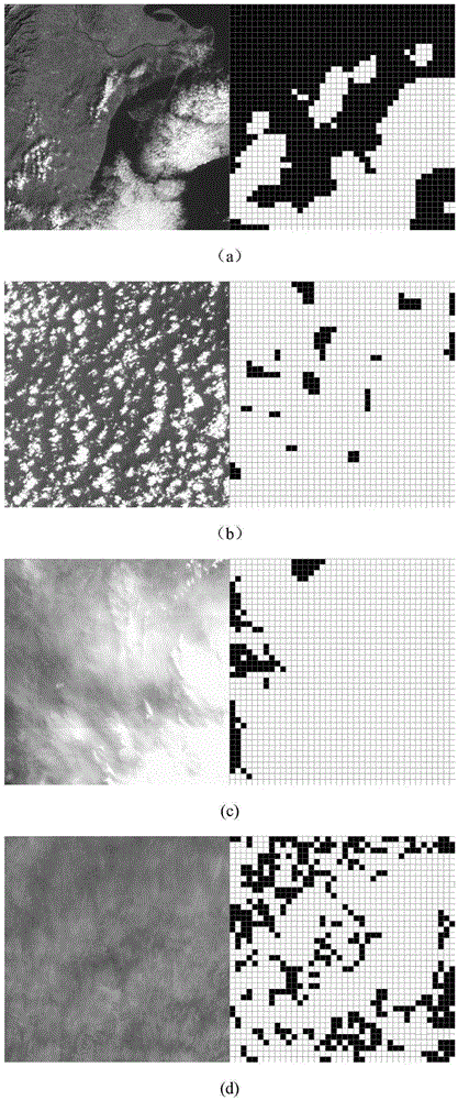
[0085] Segment the remote sensing cloud image into 32×32 pixel samples, and select 1024 cloud samples and surface object samples as the training set. Among them, cloud samples include thin clouds, point clouds, thick cumulus clouds, etc. , moun...


PUM


Abstract

The present invention discloses a satellite remote sensing image cloud amount calculation method on the basis of random forest. The satellite remote sensing image cloud amount calculation method on the basis of random forest comprises six steps: sample acquisition, feature extraction, image classifier training, segmentation of image to be measured, image classification, cloud amount calculation and the like. Through adoption of the method provided by the invention, multiple detections may be performed after training just once, an image classifier is obtained through a large number of image trainings, and the image classifier may be used again when cloud detection is performed. The random forest algorithm is low in time complexity at the prediction classification stage, and the cloud zone detection may be rapidly carried out. Through the test, the method provided by the invention is applicable to panchromatic images (ten-dimensional characteristic vector) and also applicable to n-channel multispectral images (10n-dimensional characteristic vector), and has been applied to an actual quality control system of satellite image products, so that the cloud detection of remote sensing images of multiple domestic satellites such as the resource satellite-3, mapping satellite-1, GF-1 and the like are performed, wherein the accuracies reach, respectively, 91%, 88% and 92.4%.

Description

technical field [0001] The invention belongs to the technical field of quality inspection of satellite remote sensing images, and in particular relates to a cloud amount calculation method for satellite remote sensing images based on random forests. Background technique [0002] In satellite remote sensing images, the existence of cloud areas will have a great adverse effect on the image quality and subsequent information processing. Therefore, the detection and identification of cloud cover is one of the main problems in the application field of satellite remote sensing images. The remote sensing cloud detection technology can be used to delete the data in the area where the cloud is located in the satellite remote sensing image, greatly reducing the amount of data, and avoiding the invalid data with excessive cloud cover occupying the storage space, processing power and transmission bandwidth of the system. It has on-orbit applications on satellites There are two applicati...

Claims


Application Information

Patent Timeline
20 Jan 2016
Publication
CN105260729A
IPC
G06K9/00; G06K9/46; G06K9/62
CPC
G06V20/13; G06V10/56; G06F18/2413; G06F18/241
Inventors
易尧华; 袁媛