Unmanned aerial vehicle cooperative ground covering system

A technology of drones and subsystems, applied in the field of drones, can solve the problems of low ground coverage efficiency of a single drone, excessive exposure point position deviation, and unsatisfactory paths between flight belts, etc., to achieve complete security Safety and safety, improving operational efficiency, and facilitating emergency maneuvers

Inactive Publication Date: 2016-02-10
李翔宇
View PDF8 Cites 29 Cited by
  • Summary
  • Abstract
  • Description
  • Claims
  • Application Information

AI Technical Summary

Problems solved by technology

[0008] The purpose of the present invention is to provide a UAV cooperative ground coverage system, which solves the problem of excessive position deviation of exposure poi

Method used


Image

  • Unmanned aerial vehicle cooperative ground covering system
  • Unmanned aerial vehicle cooperative ground covering system
  • Unmanned aerial vehicle cooperative ground covering system

Examples


Embodiment Construction

[0041] The technical solutions in the embodiments of the present invention will be clearly and completely described below in conjunction with the embodiments of the present invention. Apparently, the described embodiments are only some of the embodiments of the present invention, not all of them. Based on the embodiments of the present invention, all other embodiments obtained by persons of ordinary skill in the art without making creative efforts belong to the protection scope of the present invention.

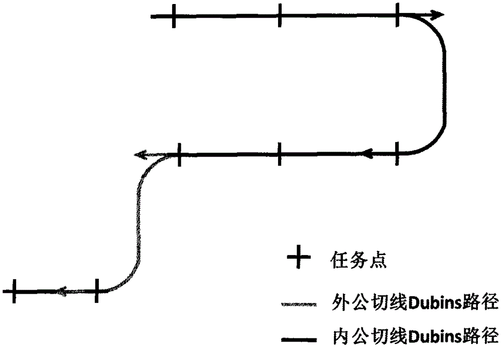
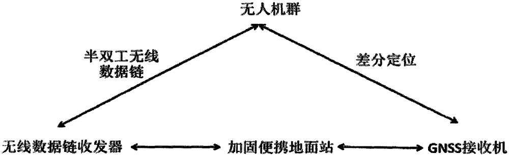
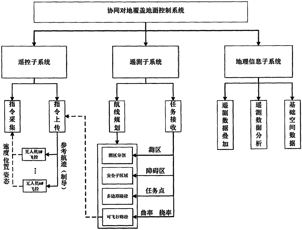
[0042] see figure 1 , in the embodiment of the present invention, the UAV cooperative ground coverage system includes a hardware system, and the hardware system is composed of a UAV group, a ground station, a communication module and a GPS reference station; the ground station and the UAV group are connected by communication modules and The GPS reference station communicates; the ground station includes a ground control system, which is composed of a remote control subsystem,...


PUM


Abstract

The invention discloses an unmanned aerial vehicle cooperative ground covering system. The unmanned aerial vehicle cooperative ground covering system comprises a hardware system. The hardware system is composed of an unmanned aerial vehicle group, a ground station, a communication module and a GPS reference station. The ground station and the unmanned aerial vehicle group communicate through the communication module and the GPS reference station. The ground station comprises a ground control system. The ground control system is composed of a remote control subsystem, a remote measuring subsystem and a geographical information subsystem. The remote control subsystem is used for instruction collection and instruction uploading. The remote measuring subsystem is used for task distribution, course programming and data receiving. The geographical information subsystem is used for processing download image data, superposing remote measured data and providing basic space data. According to the invention, the ground control system is used for completing the unmanned aerial vehicle cooperative ground covering task, the efficiency, flexibility and reliability of remote sensing and shooting measuring of the unmanned aerial vehicle are substantially enhanced, and the system can further be applied to the fields of disaster emergency surveying and mapping, offshore searching and rescuing, cooperative agricultural machinery working and the like.

Description

technical field [0001] The invention relates to the technical field of unmanned aerial vehicles, in particular to a coordinated ground coverage system for unmanned aerial vehicles. Background technique [0002] Whether in the military field or the civilian field, UAVs have great application value and broad application prospects. Ground coverage tasks are an important application of UAVs, such as UAV maritime search and rescue, UAV aerial photogrammetry, ecological monitoring, etc. The traditional ground coverage mission usually determines the flight belt nodes to plan the route in a semi-automatic way, and uses an equal-time-interval exposure method to completely cover a certain target area with one aircraft during the flight. Such a method has a small coverage area, poor system robustness, and is prone to problems such as missing chips and large overlap errors in aerial survey tasks. Therefore, there is an urgent need for a target planning method that integrates spatial p...

Claims


Application Information

Patent Timeline
IPC IPC(8): G05B13/04
Inventor 李翔宇刘春
Owner 李翔宇
Why Eureka
Try Eureka