A method for automatically compiling and drawing mountainous field ridges in 3D laser point cloud

A point cloud and mountainous technology, which is applied in image data processing, instruments, calculations, etc., can solve the problem of automatic extraction of field ridges without mountainous areas, and achieve the effect of reducing point cloud holes and noise, reducing influence, and improving accuracy and efficiency

Active Publication Date: 2018-04-20
GUIZHOU SURVEY & DESIGN RES INST FOR WATER RESOURCES & HYDROPOWER
View PDF4 Cites 0 Cited by
  • Summary
  • Abstract
  • Description
  • Claims
  • Application Information

AI Technical Summary

Problems solved by technology

At present, there is no method for automatic extraction and compilation of field ridges in mountainous areas.

Method used


Image

  • A method for automatically compiling and drawing mountainous field ridges in 3D laser point cloud

Examples


Embodiment

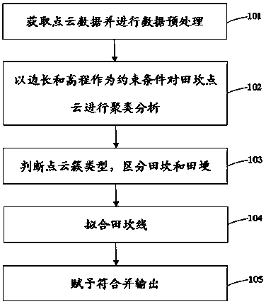
[0041] Such as figure 1 As shown, the present invention is a method for automatically editing and drawing mountainous field ridges in a three-dimensional laser point cloud. The specific steps of the method are as follows:

[0042] Step 101: Obtain the point cloud data of mountainous field ridges, and perform data preprocessing, including data splicing and data format conversion, and removal of surface vegetation and noise;

[0043] The laser scanner was used to collect data in the mountainous Duotiankan area, and the related software RISCAN PRO software was used to stitch the data, remove the vegetation and noise on the surface, and filter the point cloud data according to certain parameters, and then convert the data into .DGN format data.

[0044] Step 102: On the basis of Mircrostation v8, carry out secondary development, and use the three-dimensional space clustering algorithm based on probability theory to automatically find the ridge point;

[0045] The main steps of th...


PUM


Abstract

The invention discloses a method for automatically editing and drawing mountainous field ridges in a three-dimensional laser point cloud. The method includes: obtaining field point cloud data in mountainous areas, and performing data preprocessing; taking the side length and vertex elevation of Delaunay triangulation as constraints, A 3D space clustering method based on probability theory is proposed to cluster 3D point cloud data; judge the type of point cloud clusters, and distinguish between field ridges and ridges; connect the vertices of ridges and fit them according to certain rules; Field ridge or ridge symbol and output. The invention realizes the automation of three-dimensional point cloud editing and mapping, improves the processing efficiency and accuracy of three-dimensional point cloud data in multi-field and mountainous areas, and has good practical value and application prospect in the technical fields of three-dimensional point cloud data processing and surveying and drawing.

Description

technical field [0001] The invention relates to a method for automatically compiling and drawing mountainous field ridges in a three-dimensional point cloud, and belongs to the technical field of three-dimensional point cloud data processing and measurement and drawing. Background technique [0002] In surveying and mapping, 3D laser scanning technology provides a new tool and method for topographical surveying and geological research, which has the characteristics of high precision of measurement points, high density of collected space points, and fast speed. [0003] However, there are not many ways to automatically and efficiently extract and compile ground object information in 3D point cloud data. The feature extraction and editing functions in some software are only applicable to the automatic extraction of regular building outlines in some cities, and are helpless for the ground features in the surveying and mapping project in Guizhou mountainous areas, especially for...

Claims


Application Information

Patent Timeline
Patent Type & Authority Patents(China)
IPC IPC(8): G06T7/521
Inventor 徐锐罗天文吴恒友王陆军
Owner GUIZHOU SURVEY & DESIGN RES INST FOR WATER RESOURCES & HYDROPOWER
Why Eureka
Try Eureka