Construction method and system for two-dimensional and three-dimensional joint model of indoor environment

An indoor environment and joint model technology, applied in 3D modeling, image data processing, instruments, etc., can solve problems such as limited 3D space exploration ability, inability to provide efficient and accurate indoor environment 3D models, and low efficiency of static scanning solutions.

Active Publication Date: 2016-02-24
厦门思总建设有限公司
View PDF4 Cites 51 Cited by
  • Summary
  • Abstract
  • Description
  • Claims
  • Application Information

AI Technical Summary

Problems solved by technology

[0003] The purpose of the present invention is to propose a method for building a two-dimensional and three-dimensional joint model of an indoor environment, aiming at accurately constructing a two-dimensional grid map of the indoor environment and providing a corresponding three-dimensional point cloud model to solve t

Method used


Image

  • Construction method and system for two-dimensional and three-dimensional joint model of indoor environment
  • Construction method and system for two-dimensional and three-dimensional joint model of indoor environment
  • Construction method and system for two-dimensional and three-dimensional joint model of indoor environment

Examples


Embodiment 1

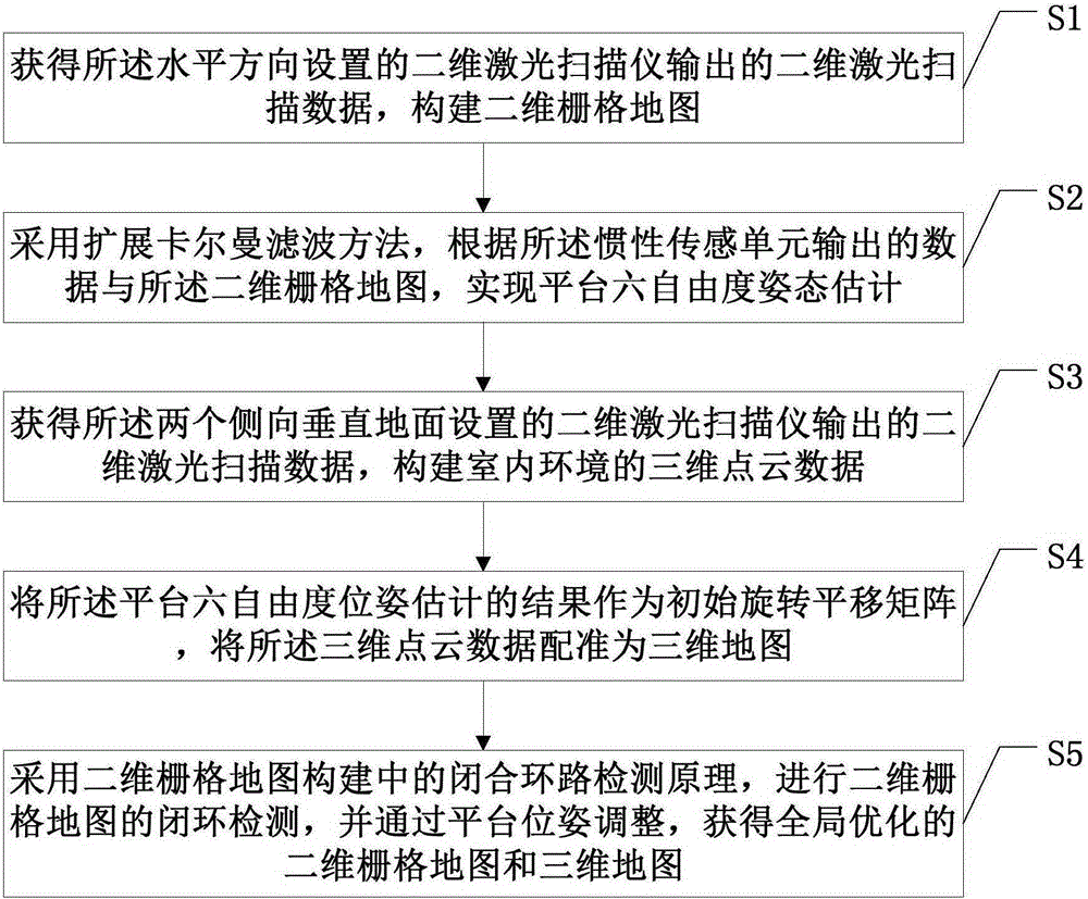
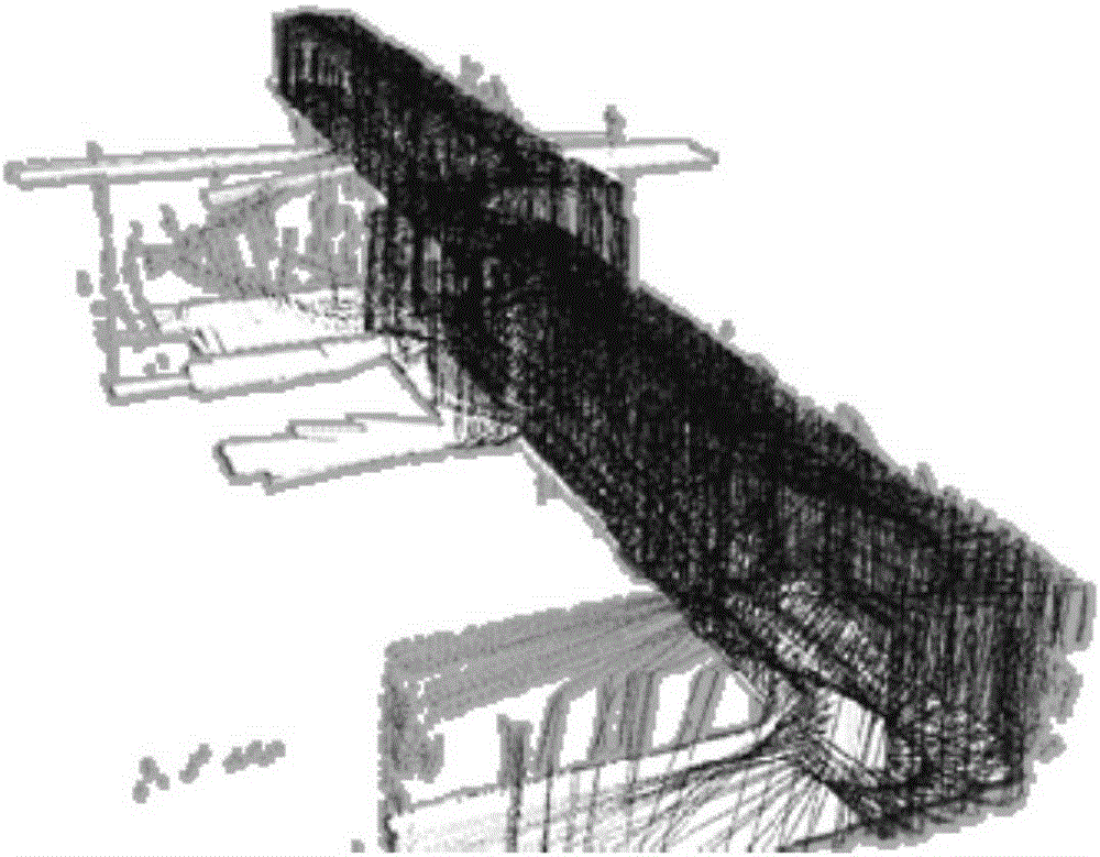
[0028] This embodiment provides a method for constructing a two-dimensional and three-dimensional joint model of an indoor environment, which includes a horizontal two-dimensional laser scanner installed along the horizontal direction at the bottom, respectively located on both sides of the horizontal two-dimensional laser scanner and at the bottom of the horizontal two-dimensional laser scanner. Two vertical two-dimensional laser scanners installed in the vertical direction, and an indoor mobile three-dimensional mapping platform of the inertial sensing unit are implemented.

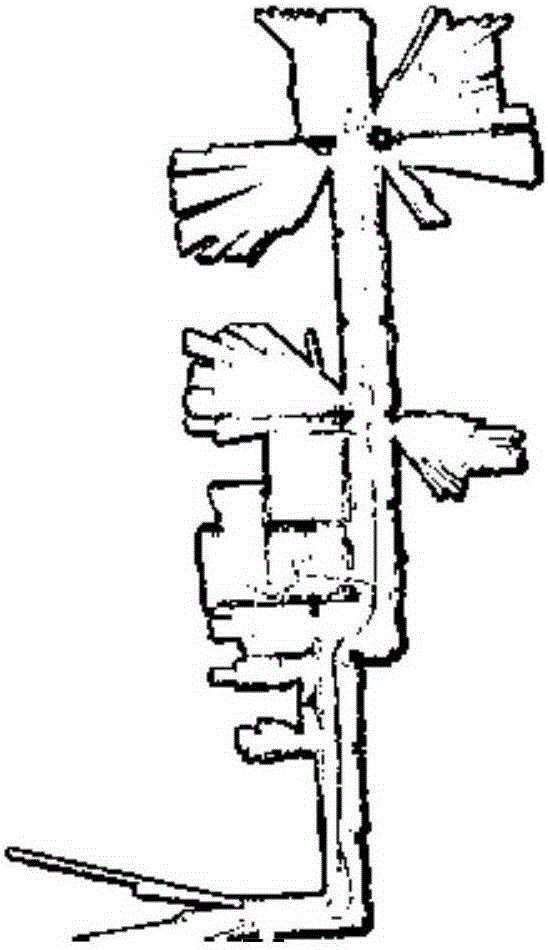
[0029] Such as figure 1 , figure 2 and image 3 As shown, the method includes the following steps S1-step S5:

[0030] S1. Obtain the two-dimensional laser scanning data output by the horizontal two-dimensional laser scanner, and construct a two-dimensional grid map;

[0031] SLAM (SimultaneousLocalizationAndMapping, synchronous positioning and map creation) refers to the construction of a map by th...


PUM


Abstract

The invention discloses a construction method and system for a two-dimensional and three-dimensional joint model of an indoor environment. The method comprises: obtaining two-dimensional laser scanning data output by a two-dimensional laser scanning instrument arranged in a horizontal direction, and constructing a two-dimensional grid map; performing platform six-degree-of-freedom pose estimation according to data output by an inertial sensing unit and the two-dimensional grid map with an extended Kalman filtering method; obtaining two-dimensional laser scanning data output by two two-dimensional laser scanning instruments with bottoms mounted in a vertical direction, and constructing three-dimensional point cloud data of the indoor environment; registering the three-dimensional point cloud data to be a three-dimensional map by taking a platform six-degree-of-freedom pose estimation result as an initial rotary translation matrix; and performing closed-loop detection of the two-dimensional grid map by adopting a closed-loop detection principle in two-dimensional grid map construction, and obtaining globally optimized two-dimensional grid map and three-dimensional map through platform pose adjustment, thereby achieving an effect of efficiently and accurately constructing two-dimensional and three-dimensional maps.

Description

technical field [0001] Embodiments of the present invention relate to the technical field of synchronous positioning and map creation, and in particular to a method and system for building a combined two-dimensional and three-dimensional model of an indoor environment. Background technique [0002] Driven by the huge application demands of digital cities, emergency response simulation and training, and digital cultural heritage, especially in typical applications such as anti-terrorism, fire protection, and smart buildings, the 3D model of the indoor environment is an indispensable basic data. Different from the outdoor environment, the indoor environment has the characteristics of close distance, multiple corners, easy occlusion, complex lighting, and lack of absolute positioning. It is a challenging subject to efficiently and accurately obtain 3D information of the indoor environment. The currently commonly used solution is based on static laser scanners for multi-site mea...

Claims


Application Information

Patent Timeline
IPC IPC(8): G06T17/00
CPCG06T17/00
Inventor 温程璐王程潘思宇李军
Owner 厦门思总建设有限公司
Why Eureka
Try Eureka