
Real-time signal receiving and processing system of public frequency points of Beidou navigation satellite system and GPS

A real-time signal and frequency point technology, applied in satellite radio beacon positioning system, radio wave measurement system, measurement device, etc., can solve different pseudo-random codes and data encoding methods, cold start time in tens of seconds, hot start About 1 second, the processing time of automatic positioning is long, and the GPS receiver cannot process the second-generation Beidou signal, etc., so as to reduce the amount of calculation and improve the processing speed and efficiency.

Inactive Publication Date: 2016-03-02
SHANGHAI INST OF TECHNICAL PHYSICS - CHINESE ACAD OF SCI
View PDF9 Cites 2 Cited by
  • Summary
  • Abstract
  • Description
  • Claims
  • Application Information

AI Technical Summary

Problems solved by technology

[0004] Beidou II uses the same carrier frequency and modulation method as GPS, but uses a different pseudo-random code and data encoding method, GPS receivers cannot process Beidou II signals
And a small number of receivers that can process Beidou 2nd generation signals are only post-processed by general-purpose GPS receivers, but they still cannot be used as real-time applications.
Generally, the cold start time of the GPS hardware receiver is tens of seconds, the hot start is about 1 second, and the processing time of automatic positioning is more than 10 seconds

Method used


Image

  • Real-time signal receiving and processing system of public frequency points of Beidou navigation satellite system and GPS
  • Real-time signal receiving and processing system of public frequency points of Beidou navigation satellite system and GPS
  • Real-time signal receiving and processing system of public frequency points of Beidou navigation satellite system and GPS

Examples


Embodiment Construction

[0046] The present invention will be further described below in conjunction with the accompanying drawings and implementation examples. The present invention includes two parts, a hardware technical solution and a software technical solution.

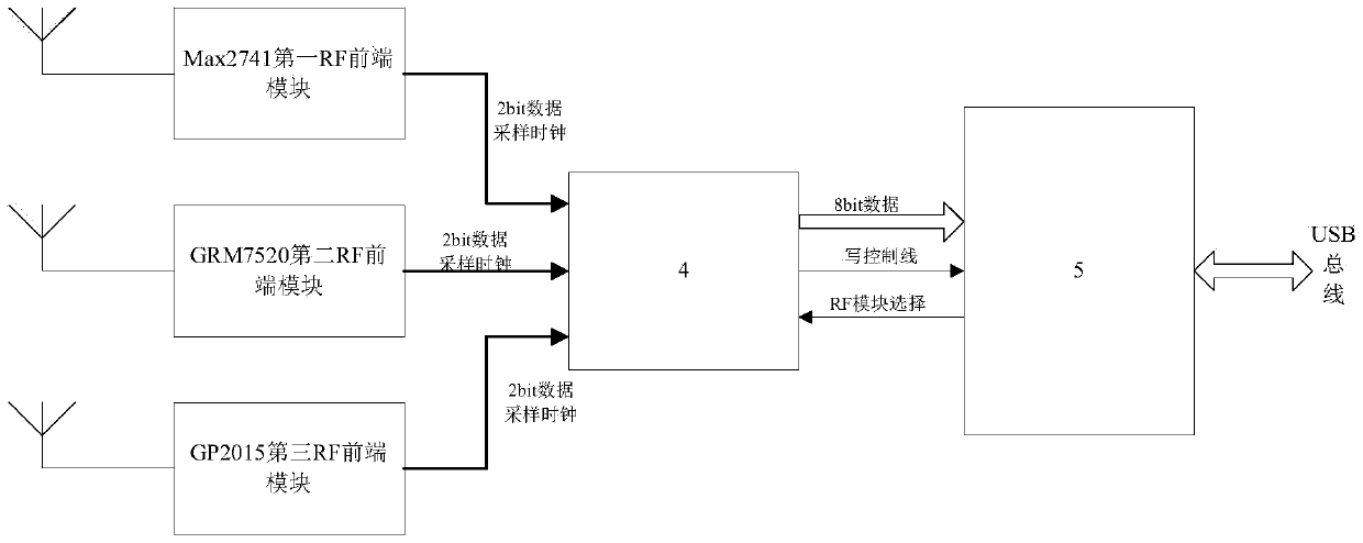
[0047] hardware technology solutions such as figure 1 As shown, the real-time signals of Beidou II and GPS public frequency points enter the radio frequency front-end (RF) module through the same antenna, undergo a series of amplification, filtering and down-conversion processing, and convert them into 2-bit intermediate frequency digital signals through A / D. Under the control of the FPGA, the intermediate frequency digital signal is collected into the internal FIFO of the FPGA and stored in a certain length of data blocks in a ping-pong manner. Finally, through the USB controller, transfer to the computer in blocks. The hardware solution mainly includes the following parts:

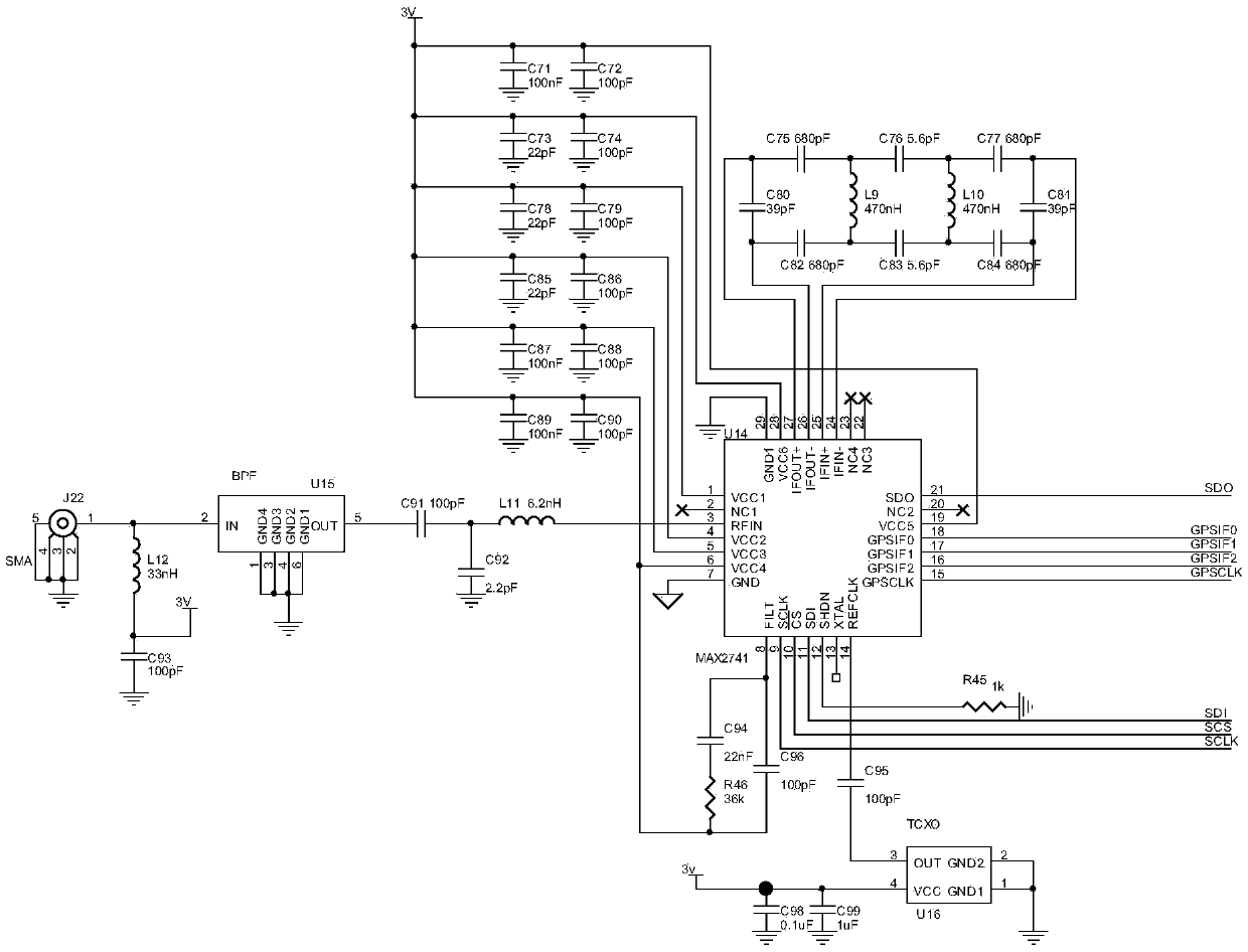
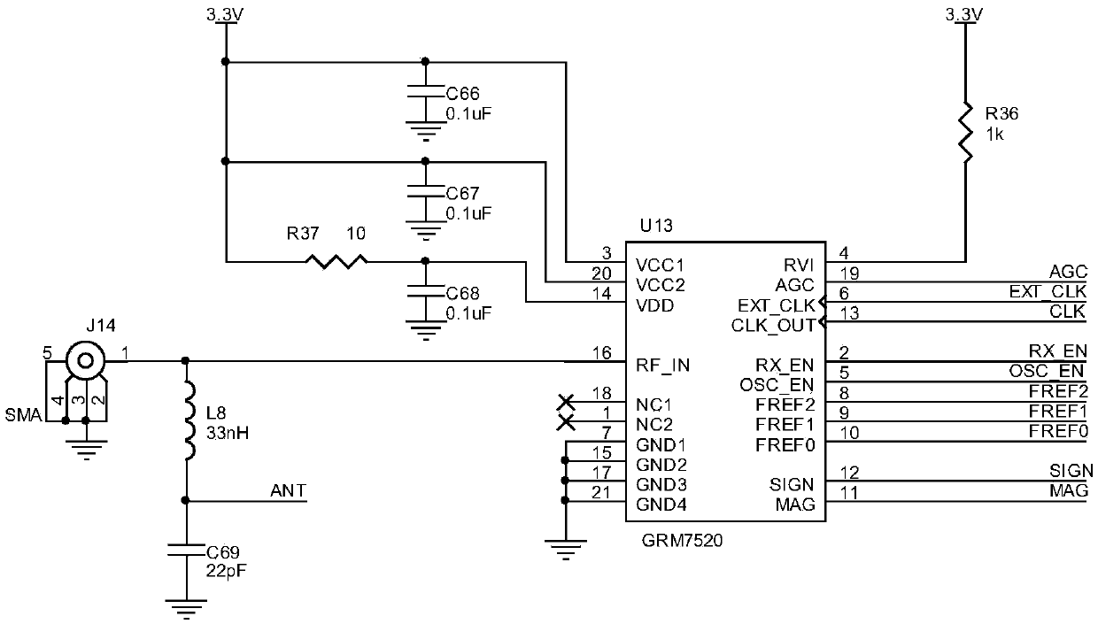
[0048] Such as figure 2 As shown, a Max2741 main chip ...


PUM


Abstract

The present invention discloses a real-time signal receiving and processing system of public frequency points of a Beidou navigation satellite system and a GPS. Signals of the public frequency points of the Beidou navigation satellite system and the GPS enter three RF radio frequency front end modules through the same antenna, are subjected to a series of amplification, filtering and down-conversion processing, and are converted to 2bit medium frequency digital signals through the A / D (Analog to Digital) conversion, and the medium frequency digital signals are acquired to the internal storage of an FPGA under the control of the FPGA, are stored to be a data block with a certain length in a ping-pong mode, and are transmitted to a computer in a block mode through a USB controller. The real-time signal receiving and processing system of public frequency points of a Beidou navigation satellite system and a GPS is able to perform rapid capture and real-time data processing of signals of the public frequency points of the Beidou navigation satellite system and the GPS on the software architecture of a computer platform, and the like, therefore positioning accuracy, reliability, integrity and availability of a single positioning system are substantially improved; and moreover, the software development on the basis of the software radio technology is performed, thereby getting rid of the algorithm of a traditional hardware receiver and realizing the reconfiguration of a research mode.

Description

Technical field: [0001] The invention relates to a signal receiving and processing system for navigation and positioning, in particular to a system for receiving and processing real-time signals of Beidou II and GPS public frequency points. Background technique: [0002] The "2006 China Aerospace White Paper" announced that five major aerospace projects will be launched in the next five years, and the deployment of the second-generation "Beidou" satellite navigation system with military applications will be completed within four years. Some experts said that after the deployment of the second-generation "Beidou" satellite system is completed, China will be able to launch precise attacks on small targets, and some media in the United States believe that China is using the Beidou project to suppress the military advantage of American satellites. With the improvement of my country's comprehensive national strength and the comprehensive penetration of the satellite navigation an...

Claims


Application Information

Patent Timeline
Patent Type & Authority Applications(China)
IPC IPC(8): G01S19/37
CPCG01S19/33G01S19/35G01S19/37
Inventor 张雷邓江平
Owner SHANGHAI INST OF TECHNICAL PHYSICS - CHINESE ACAD OF SCI
Learn More