Automatic extraction method for airborne SAR scaler image position

An automatic extraction and scaler technology, which is applied in the field of radar detection, can solve the problems of mistaking non-scaler points for scalers, manual search methods require a lot of work, and consume more time and energy, so as to avoid interpretation errors and errors, accurate and reliable extraction results, saving manpower and energy

Active Publication Date: 2016-03-16
INST OF ELECTRONICS CHINESE ACAD OF SCI
View PDF6 Cites 6 Cited by
  • Summary
  • Abstract
  • Description
  • Claims
  • Application Information

AI Technical Summary

Problems solved by technology

[0004] (1) The manual search method has a large workload, slow speed, and takes a long time
Especially in the case of large scenes and many calibration points, manually searching for calibration points will consume more time and energy, which is difficult, lacks practicability, and is difficult to apply to large-scale engineering projects
[0005] (2) The manual search method may cause positioning errors
Compared with the real scene, the SAR image (before geocoding) has a certain distortion, which brings some difficulties to manually find the scaler, especially when there are other strong point targets around the scaler. misidentified as a scaler, leading to wrong lookup results
[0006] (3) The manual search method is prone to search errors
The brightness of the center and surrounding areas of the scaler in the image is brighter, and it is difficult to distinguish the brightest pixel center directly with the naked eye, so it may cause a search error (pixel-level error)

Method used


Image

  • Automatic extraction method for airborne SAR scaler image position
  • Automatic extraction method for airborne SAR scaler image position
  • Automatic extraction method for airborne SAR scaler image position

Examples


Embodiment Construction

[0027] The present invention will be described in detail below with reference to the accompanying drawings and examples.

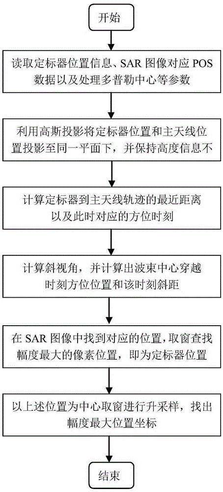
[0028] The invention provides a method for automatically extracting the image position of an airborne SAR scaler, the flow chart of which is as follows figure 1 As shown, the specific implementation steps are as follows:

[0029] Step 1. Read the position information (latitude, longitude and height information) of the scaler, read the position information (latitude, longitude and height information) of the SAR main antenna at each azimuth moment corresponding to the SAR image, and the position information of the SAR image Handle parameters such as Doppler center.

[0030] In practical applications, the location information of the scaler is given by latitude, longitude and height information. At the same time, the SAR image will also give the POS data corresponding to the scene image (SAR image). The POS data records the scene image every The location inf...


PUM


Abstract

Disclosed in the invention is an automatic extraction method for an airborne SAR scaler image position. With the method, a scaler can be searched automatically in an SAR image rapidly and accurately; and the positioning precision is high. Position information of a scaler and an SAR main antenna as well as an SAR image processing Doppler central frequency is extracted; longitude and latitude information of the scaler and the SAR main antenna are projected to the same plane, and the height information is not changed; a shortest distance between the position of the scaler and the movement locus of the main antenna is calculated and a nearest slant range and a zero Doppler time are obtained; a slant range of the scaler at a wavebeam center passing-through time as well as an azimuth position of the main antenna at the wavebeam center passing-through time is determined based on strabismus geometry; the slant range and the azimuth positio are used as an initial distance position and an initial azimuth positio of the scaler in the SAR image; and then a searching window is taken by using the initial position as a center and the position of a pixel point with the highest intensity in the searching window is the position of the scaler in the SAR image.

Description

technical field [0001] The invention relates to the technical field of radar detection, in particular to a method for automatically extracting image positions of an airborne SAR scaler. Background technique [0002] Airborne synthetic aperture radar (SAR) is an active microwave imaging sensor, which uses the relative motion between the radar and the target to synthesize a smaller real antenna aperture into a larger equivalent antenna aperture through data processing, thereby Achieve high-resolution imaging. SAR can detect and locate targets all day and all weather, and is less affected by weather, so it has been widely used in military reconnaissance, terrain mapping and other fields. [0003] The scaler is a tool used in SAR calibration, which is divided into passive scaler and active scaler. A passive scaler is a metal device with a strong retroreflection coefficient and a certain geometric shape, while an active scaler is a calibration device that can actively transmit ...

Claims


Application Information

Patent Timeline
Patent Type & Authority Applications(China)
IPC IPC(8): G01S13/90
CPCG01S13/9005G01S13/9004
Inventor 曾友兵洪峻王宇
Owner INST OF ELECTRONICS CHINESE ACAD OF SCI
Why Eureka
Try Eureka