Unmanned plane three-dimensional flight track precision detection method and system

A technology of track accuracy and detection method, which is applied in the field of detection method and system of UAV flight three-dimensional track accuracy, which can solve the problem of inability to obtain UAV flight three-dimensional track accuracy, inability to detect UAV actual flight track, etc. problem, to achieve the effect of ensuring comparability, realizing high-precision positioning, and solving the large amount of data collection

Inactive Publication Date: 2016-03-30
TIANJIN AEROSPACE ZHONGWEI DATA SYST TECH CO LTD +1
View PDF4 Cites 10 Cited by
  • Summary
  • Abstract
  • Description
  • Claims
  • Application Information

AI Technical Summary

Problems solved by technology

[0006] For this reason, the object of the present invention is to provide a method and system for detecting the accuracy of the UAV flight three-dimensional track, so as to solve the problem that the actual flight track of the UAV cannot be detected in the prior art, and then the accurate three-dimensional flight path of the UAV cannot be obtained. Defects in track accuracy

Method used


Image

  • Unmanned plane three-dimensional flight track precision detection method and system
  • Unmanned plane three-dimensional flight track precision detection method and system
  • Unmanned plane three-dimensional flight track precision detection method and system

Examples


Embodiment 1

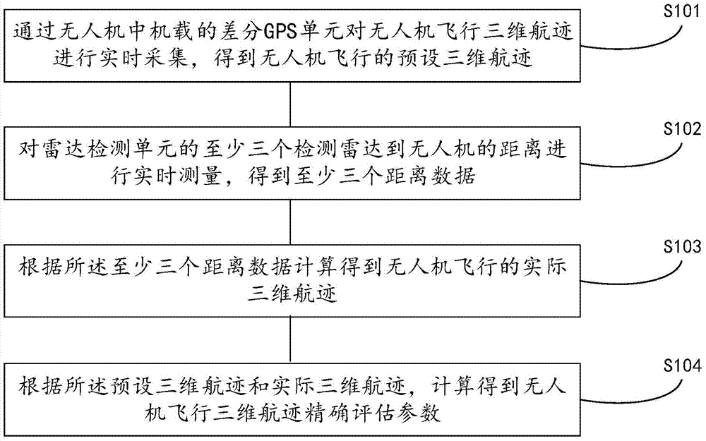
[0067] refer to figure 1 The schematic flow chart of the three-dimensional track accuracy detection method for unmanned aerial vehicles shown, the specific steps of the present invention are implemented as follows:

[0068] In step S101, the differential GPS unit on board the UAV is used to collect the three-dimensional flight track of the UAV in real time to obtain a preset three-dimensional flight track of the UAV;

[0069] The differential GPS unit is set in the on-board equipment of the UAV. During the flight of the UAV, the first intelligent control unit in the on-board equipment controls the UAV to fly according to the preset track. The three-dimensional flight track of the flight is collected in real time.

[0070] In this step, in order to ensure the one-to-one correspondence between the acquisition time and the three-dimensional track, the first timing unit can also be set in the airborne equipment, and the first intelligent control unit controls the first timing uni...

Embodiment 2

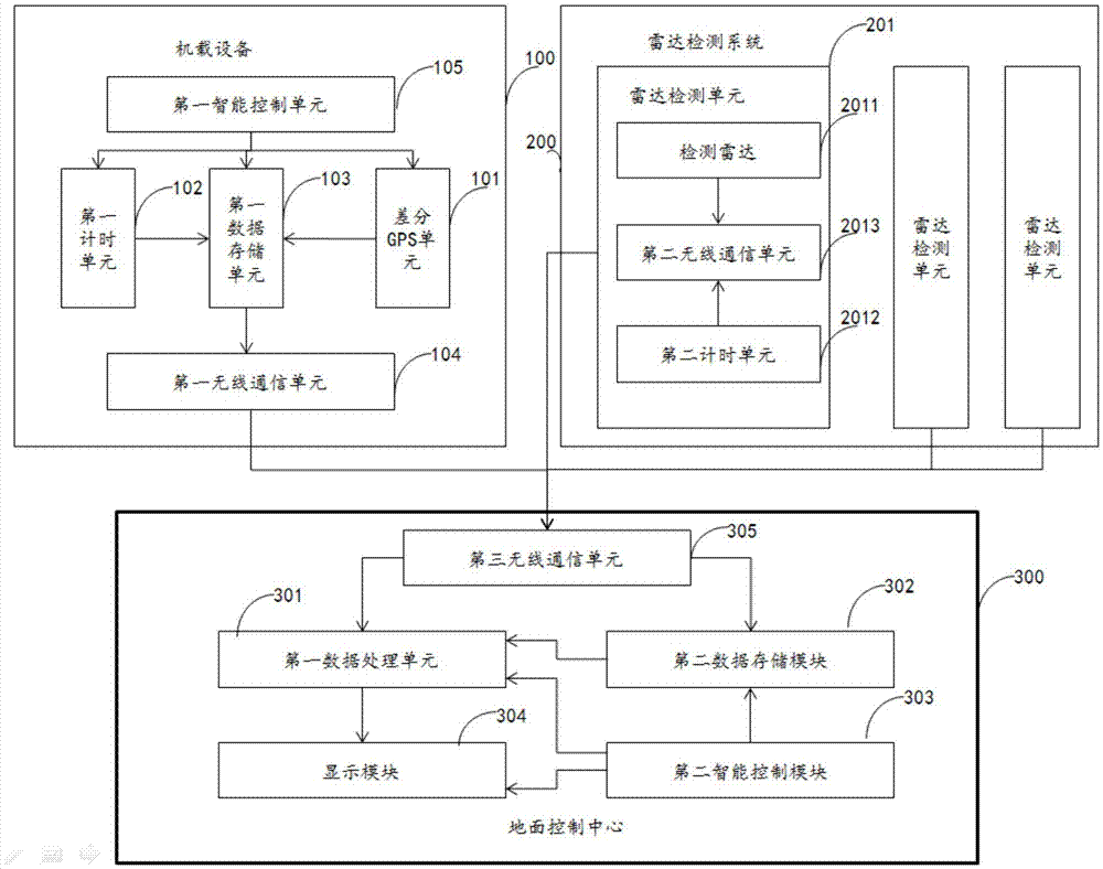
[0100] Corresponding to the method provided in Embodiment 1, this embodiment provides a three-dimensional track accuracy detection system for UAV flight, such as figure 2 The system architecture diagram shown, the system includes the following modules:

[0101] The differential GPS unit 101 is arranged in the on-board device 100 of the UAV, and is used to collect the three-dimensional flight track of the UAV in real time, so as to obtain the preset three-dimensional flight track of the UAV flight;

[0102] The radar detection unit 201 is arranged in the radar detection system 200, the radar detection system 200 includes at least three radar detection units, each radar detection unit includes at least one detection radar 2011, and the detection radar 2011 is used to detect The distance between man and machine is measured in real time, and at least three distance data are obtained;

[0103] According to the size of the monitoring area of ​​the UAV, more radar detection units c...


PUM


Abstract

The invention discloses an unmanned plane three-dimensional flight track precision detection method and system. The method comprises the steps of acquiring the three-dimensional flight track of an unmanned plane in real time by an airborne differential GPS unit arranged in the unmanned plane to obtain a preset three-dimensional flight track of the unmanned plane; measuring the distances between at least three detection radars of a radar detection unit and the unmanned plane in real time to obtain at least three distance data; calculating the actual three-dimensional flight track of the unmanned plane based on the at least three distance data; and calculating accurate assessment parameters for the three-dimensional flight track of the unmanned plane based on the preset three-dimensional flight track and the actual three-dimensional flight track. According to the technical scheme of the invention, the unmanned plane can be three-dimensionally positioned by the extra arrangement of the detection radars, so that the actual flight track of the unmanned plane can be positioned at a high precision. Meanwhile, through comparing the three-dimensional flight track of the unmanned plane detected by the differential GPS unit with the actual three-dimensional flight track of the unmanned plane, the accurate three-dimensional flight track precision of the unmanned plane can be obtained. Therefore, the actual flight track of the unmanned plane can be positioned at a high precision.

Description

technical field [0001] The invention belongs to the technical field of unmanned aerial vehicles, and in particular relates to a method and system for detecting the accuracy of a three-dimensional flight track of an unmanned aerial vehicle. Background technique [0002] With the rapid development of the application of UAVs in the field of electric power inspection, the traditional working mode of using manual on-site inspection of transmission lines is slowly changing. The traditional manual inspection method takes a long time, has high labor costs, and is difficult, and it is easy to affect the personal safety of inspection personnel in special environments. UAV inspections can not only improve the efficiency of inspection operations and save costs, but also record the characteristics of transmission lines, the environment of transmission lines, and the trajectory of UAV inspections in different forms (including video, visible light / infrared images, etc.) efficient storage....

Claims


Application Information

Patent Timeline
Patent Type & Authority Applications(China)
IPC IPC(8): G01S13/58G01S7/40G01S19/42
CPCG01S7/40G01S13/58G01S19/42
Inventor 王晓婧杨鹤猛张巍吴新桥张贵峰赵克陈艳芳廖永力张拯宁周筑博赵恩伟王兵王诗奎
Owner TIANJIN AEROSPACE ZHONGWEI DATA SYST TECH CO LTD
Why Eureka
Try Eureka