Method for collecting spatial population distribution in real time on basis of mobile phone big data and realizing large passenger flow early warning

A technology of spatial distribution and real-time collection, applied in data processing applications, electrical digital data processing, special data processing applications, etc., can solve problems such as the inability to reflect the dynamic migration and changes of population distribution, and the limited timeliness of data.

Inactive Publication Date: 2016-04-13
上海川昱信息科技有限公司
View PDF4 Cites 34 Cited by
  • Summary
  • Abstract
  • Description
  • Claims
  • Application Information

AI Technical Summary

Problems solved by technology

[0003] Traditional population distribution data can only be obtained through multi-year censuses, the timeliness of the data is extremely limited, and it cannot reflect the dynamic migration changes of population distribution

Method used


Image

  • Method for collecting spatial population distribution in real time on basis of mobile phone big data and realizing large passenger flow early warning
  • Method for collecting spatial population distribution in real time on basis of mobile phone big data and realizing large passenger flow early warning
  • Method for collecting spatial population distribution in real time on basis of mobile phone big data and realizing large passenger flow early warning

Examples


Embodiment

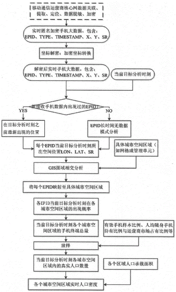
[0035] Step 1. Obtain real-time anonymous encrypted mobile phone data from the mobile phone communication operator in real time, use a dedicated decryption module to decrypt and convert coordinates, and map it to a specific urban geographic location in real time. The decrypted data includes EPID (anonymous single EncryPtioninternationalmobilesubscriberIDentity), TYPE (the mobile network action type involved in the current record), TIMESTAMP (the time stamp of the mobile network action involved in the current record), LON (real longitude coordinates), LAT (true latitude coordinates), SR (spatial error range).

[0036] The decrypted data in this embodiment is shown in Table 1 below.

[0037] Table 1: Newly received real-time cell phone data after decryption.

[0038] RECORDID

EPID

TYPE

time

LON

LAT

SR

……

……

……

……

……

……

……

RECORD(r1-1)

EPID(e1)

T1

2015-01-02 00:57:00

121.303094

31.343088 ...


PUM


Abstract

The invention aims at providing a method for collecting spatial population distribution in real time on the basis of mobile phone big data and realizing large passenger flow early warning. The method is characterized by comprising the following steps of obtaining real-time mobile phone big data from a mobile phone communication operator at each statistics moment; dividing a target region into different space regions; at the current statistics moment, mapping the latest space position of each EPID (Electronic Portal Imaging Device) obtained in the first step to each space region of the target region; and obtaining the real population size (the distribution condition of the total population in the whole target region) in each space region at the current statistics moment. The method has the advantages that the sufficient relying on the existing mobile phone big data resources is realized; the continuous encrypted position information of the existing mass anonymous mobile phone users in the mobile communication network is used; the low-cost high-frequency and automatic implementation can be realized; and the popularization distribution data in a large-range urban space range can be continuously obtained in a fast deploying way.

Description

technical field [0001] The invention relates to a method for collecting urban population spatial distribution data in real time based on massive anonymous encrypted mobile phone big data, and sending early warning information in time when the passenger flow is large (close to the regional population carrying limit), which is used for high-frequency and automatic acquisition The spatial distribution data of urban population can serve urban operation management, urban planning, and policy evaluation and formulation, and belongs to the technical field of urban operation management and urban planning. Background technique [0002] The coordinated development of regional population, resources, and environment is one of the trends in economic and social development, and the integration of population, resources, environment, and other economic and social information for comprehensive analysis is the basic condition for solving regional population, resource, and environmental problem...

Claims


Application Information

Patent Timeline
Patent Type & Authority Applications(China)
IPC IPC(8): G06F17/30G06Q50/00H04W4/02
CPCG06F16/9537G06Q50/01H04W4/029
Inventor 刘杰李明敏裘炜毅张颖陈烨
Owner 上海川昱信息科技有限公司
Why Eureka
Try Eureka