Combined navigation method for underwater vehicle based on individual seabed transponder

An underwater vehicle and integrated navigation technology, which is applied in the direction of navigation, navigation, surveying and navigation through speed/acceleration measurement, can solve the problems of limited navigation area, complex project implementation, high risk, and low efficiency, and achieve The effect of improving navigation accuracy

Inactive Publication Date: 2016-04-27
中国人民解放军91388部队
View PDF5 Cites 3 Cited by
  • Summary
  • Abstract
  • Description
  • Claims
  • Application Information

AI Technical Summary

Problems solved by technology

The navigation and positioning accuracy of the long baseline is high, but the navigation area covered by multiple submarine transponders is limited, the ef...

Method used


Image

  • Combined navigation method for underwater vehicle based on individual seabed transponder
  • Combined navigation method for underwater vehicle based on individual seabed transponder
  • Combined navigation method for underwater vehicle based on individual seabed transponder

Examples


Embodiment 1

[0027] As in 1, figure 2 As shown, the specific implementation process of the underwater vehicle integrated navigation method based on a single seabed transponder described in this embodiment is as follows:

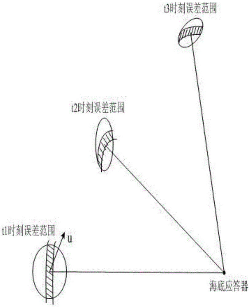
[0028] 1. Deploy a submarine transponder in the sea area and measure its exact position. The operating range of the submarine transponder is 6km, thus forming a spherical coverage area with the transponder as the center and a radius of 6km for the underwater vehicle;

[0029] 2. The aircraft transmits an inquiry pulse at a period of 8s. When the aircraft enters the effective coverage area of ​​the transponder, the transponder generates a response signal after receiving the interrogation pulse, and the aircraft performs fusion based on the response signal and its own integrated navigation measurement results, thereby Improve navigation accuracy.

[0030] The following is a detailed introduction to the calculation process of the underwater vehicle integrated navigation m...


PUM


Abstract

The invention discloses a combined navigation method for an underwater vehicle based on an individual seabed transponder. The method comprises the following steps that: (1) one seabed transponder is laid in a sea area and the accurate position of the seabed responder is measured out, wherein the action scope of the seabed responder is 6 km, so a spherical covering area with the seabed responder as a spherical centre and a radius of 6 km is formed for the underwater vehicle; and (2) the underwater vehicle emits an inquiry pulse with a period of 8 s, the seabed responder generates an answering signal after receiving the inquiry pulse when the underwater vehicle enters the covering area of the seabed responder, and then the underwater vehicle merges the answering signal and combined navigation measurement results to form a navigation path with improved navigation precision. The method has the advantage of high navigation precision which becomes more and more obvious with accumulation of time. Compared with a long-baseline navigation positioning method, the method provided by the invention has the following advantages: a large navigation area can be covered by laying an individual seabed responder, so a cost-benefit ratio is greatly increased, and engineering risks are reduced.

Description

technical field [0001] The invention relates to the technical field of underwater target navigation and positioning, in particular to an integrated navigation method for underwater vehicles based on a single seabed transponder. Background technique [0002] Navigation and positioning of underwater vehicles is an important issue in the field of underwater acoustic technology. There are currently two main navigation methods for underwater vehicles. One is the integrated navigation method based on the inertial navigation system (Inertial Navigation System, INS). Doppler velocity measurement system (DopplerVelocityLog, DVL) and estimated ship position, etc. The accuracy of INS mainly depends on the inertial device, and the navigation accuracy error will continue to increase over time. The second is the long-baseline underwater vehicle navigation and positioning method, which relies on multiple underwater acoustic transponders deployed on the seabed to perform spherical interse...

Claims


Application Information

Patent Timeline
IPC IPC(8): G01C21/00G01C21/16
CPCG01C21/00G01C21/165
Inventor 彭水孙向前徐国贵朱元林李帅张永超
Owner 中国人民解放军91388部队
Why Eureka
Try Eureka