Pose solving method based on wireless positioning and laser map matching

A wireless positioning and map matching technology, applied in directions such as road network navigators, can solve the problems of high positioning accuracy requirements and can not meet the autonomous navigation system of mobile robots, and achieve the effect of avoiding low accuracy and avoiding positioning position jumps.

Active Publication Date: 2016-05-04
河南布科思机器人有限公司
View PDF6 Cites 45 Cited by
  • Summary
  • Abstract
  • Description
  • Claims
  • Application Information

AI Technical Summary

Problems solved by technology

The application of mobile robots requires high positioning accuracy. Among the above-mentioned wireless positioning technologies, UWB positioning technology has the highest positioning accuracy. Its ideal positi...

Method used


Image

  • Pose solving method based on wireless positioning and laser map matching
  • Pose solving method based on wireless positioning and laser map matching
  • Pose solving method based on wireless positioning and laser map matching

Examples


Embodiment Construction

[0027] The present invention will be described in detail below in conjunction with the accompanying drawings and specific embodiments. The following description is only for demonstration and explanation, and does not limit the present invention in any form.

[0028] The pose calculation method based on wireless positioning and laser map matching includes the following steps:

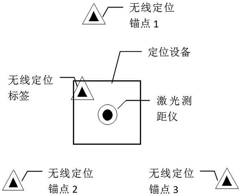
[0029] Step 1: Deploy at least three wireless positioning anchors in different positions in the environment, ensuring that all wireless positioning anchors do not form a straight line in space;

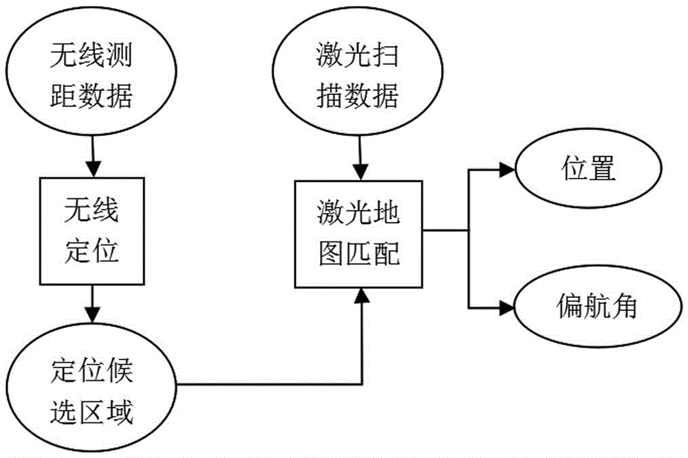
[0030] Step 2: Use the positioning device installed with the laser scanner and the wireless positioning tag, based on the simultaneous positioning and map construction algorithm (Simultaneous Localization and Mapping, SLAM), construct a global laser map, and record the current position of the positioning device and the positioning device and each wireless positioning anchor at the same time distance between poin...


PUM


Abstract

The invention discloses a pose solving method based on wireless positioning and laser map matching. The method combines wireless locating method and laser scanning positioning, and realizes an indoor high precision positioning method independent of a satellite positioning system. The method also realizes calculation of a positioning equipment yaw angle. The method not only avoids the low accuracy disadvantage of wireless location, but also avoids the circumstance that positioning location jump is likely to occur due to the interference of environmental change to laser scanning positioning. The high precision pose calculating method realized by the invention can be widely applied to location-based service and mobile robot autonomous navigation field, and is one of the key core technologies of location-based service application and mobile robots.

Description

technical field [0001] The invention relates to the technical field of indoor positioning, autonomous positioning and navigation of mobile robots and unmanned vehicles, in particular to a pose calculation method based on wireless positioning and laser map matching. Background technique [0002] In location service applications, the service content and mode are closely related to the location of the service object, so locating the service object is the first problem to be solved in the location service application. In an outdoor environment, a currently feasible and commonly used solution is to use satellite positioning. However, in indoor environments or places where satellite positioning cannot work normally, other methods must be used to achieve positioning. This is the content of the current research on indoor positioning technology. accurate locating. [0003] In order to be practical, mobile robots must have the ability to move through the terrain, accurate and effici...

Claims


Application Information

Patent Timeline
IPC IPC(8): G01C21/30
CPCG01C21/30
Inventor 谢传泉
Owner 河南布科思机器人有限公司
Why Eureka
Try Eureka