High-precision land cover classification method based on high-resolution satellite image

A satellite image and land cover technology, applied in the field of remote sensing information processing, can solve the problems of unsuitability for practical use, broken classification result data, and low extraction accuracy, and achieve the effects of improving classification efficiency and accuracy, classification accuracy, and computing efficiency.

Active Publication Date: 2016-05-25
CHINA CENT FOR RESOURCES SATELLITE DATA & APPL
View PDF4 Cites 17 Cited by
  • Summary
  • Abstract
  • Description
  • Claims
  • Application Information

AI Technical Summary

Problems solved by technology

This method requires more manual intervention, more subjective judgments, and the results are more fragmented
[0007] In general, the above methods have the following disadvantages: (1) The method is relatively primitive and the extraction accuracy is low; (2) The extraction process requires auxiliary manual intervention, and even requires on-site measurement and manual sketching, which is time-consuming and laborious ; (3) For different remote sensing satellite multispectral data, different calculation models and thresholds are required, and the universality is low; (4) For high-resolution images, the classification result data of the pixel-oriented method is relatively fragmented, which is not suitable for practical use

Method used


Image

  • High-precision land cover classification method based on high-resolution satellite image
  • High-precision land cover classification method based on high-resolution satellite image
  • High-precision land cover classification method based on high-resolution satellite image

Examples


Embodiment Construction

[0050] Specific embodiments of the present invention will be further described in detail below in conjunction with the accompanying drawings.

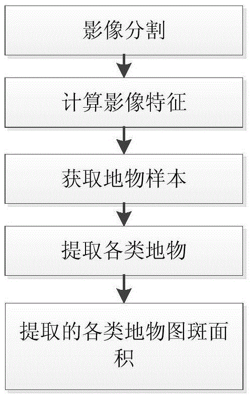
[0051] like figure 1 As shown, a high-precision land cover classification method based on high-resolution satellite imagery includes:

[0052] (1) Determine the patch areas with similar properties in satellite remote sensing images, and perform reasonable image segmentation;

[0053](1a) Calculate the apparent reflectance according to the gray value of the satellite remote sensing image, and the calculation process is as follows:

[0054] (1a1) Convert the gray value of the image to the apparent radiance according to the formula:

[0055] L a =Gain×DN+Bias

[0056] Among them, Gain is the gain, DN is the gray value, and Bias is the offset. These parameters can be obtained from the XML corresponding to the image.

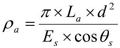
[0057] (1a2) Convert the apparent radiance to apparent reflectance as follows:

[0058] ρ ...


PUM


Abstract

The invention provides a land cover classification method which comprises the steps of (1) determining plaque areas with similar domestic remote sensing image characters and than carrying out reasonable image segmentation, (2) according to the different areas divided in the step (1), by using spectrum, texture and geometrical characteristics, calculating an image characteristic, (3) by using historical land use data and a ground object spectral library, combined with the image characteristic in the step (2), a ground object sample is obtained automatically, (4) with the ground object sample of the step (3) as an information entropy, various types of ground objects are extracted by using a decision tree and the boosting technology, (5) calculating various types of ground object plaque areas, carrying out plaque combination and elimination according to a set value, and finally obtaining a classification result. The problems of wrong land cover classification and multiple broken plaques are solved, thus the operation efficiency is improved by 50%, and the classification accuracy is raised to 90%.

Description

technical field [0001] The invention relates to an object-oriented high-precision land cover classification method based on domestic high-resolution satellite images, which is suitable for land cover classification of multi-spectral images of domestic remote sensing satellites without cloud coverage, and belongs to the field of remote sensing information processing. Background technique [0002] With the development of the economy, the damage to the global environment is becoming more and more serious. Problems such as droughts and floods, illegal occupation of agricultural land, and deforestation frequently occur and seriously affect people's lives, social and economic development, and social stability. Using remote sensing information to quickly and scientifically , Accurately classify and evaluate the land cover, grasp the situation of regional land cover in a timely manner, and take corresponding countermeasures in time, which play an important role in the rational planni...

Claims


Application Information

Patent Timeline
Patent Type & Authority Applications(China)
IPC IPC(8): G06K9/62G06K9/46
CPCG06V10/40G06F18/24
Inventor 高青山傅俏燕隋正伟吕争李俊杰乔志远崔林
Owner CHINA CENT FOR RESOURCES SATELLITE DATA & APPL
Why Eureka
Try Eureka