Real-time panoramic stitching method and system for unmanned aerial vehicle images

A technology of drones and images, which is applied in graphics and image conversion, image data processing, photogrammetry/video metrology, etc., can solve the problem that the processing efficiency is difficult to meet the requirements of data immediacy, and achieve the improvement of data processing speed , the effect of improving efficiency

Inactive Publication Date: 2016-06-01
WUHAN UNIV
View PDF2 Cites 52 Cited by
  • Summary
  • Abstract
  • Description
  • Claims
  • Application Information

AI Technical Summary

Problems solved by technology

Such processing efficiency is difficult to meet the requirements of data imme

Method used


Image

  • Real-time panoramic stitching method and system for unmanned aerial vehicle images
  • Real-time panoramic stitching method and system for unmanned aerial vehicle images
  • Real-time panoramic stitching method and system for unmanned aerial vehicle images

Examples


Embodiment Construction

[0046]The principles and features of the present invention are described below in conjunction with the accompanying drawings, and the examples given are only used to explain the present invention, and are not intended to limit the scope of the present invention.

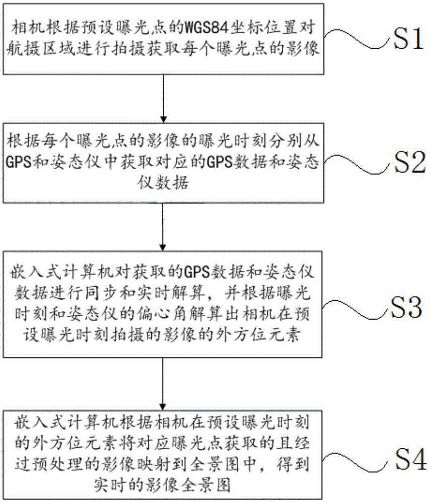
[0047] Such as figure 1 As shown, a method for real-time panorama stitching of UAV images, including the following steps,

[0048] S1, the camera shoots the aerial photography area according to the WGS84 coordinates (geocentric coordinates) of the preset exposure point to obtain the image of each exposure point.

[0049] S2. Obtain corresponding GPS data and attitude instrument data from the GPS and the attitude instrument according to the exposure time of the image of each exposure point.

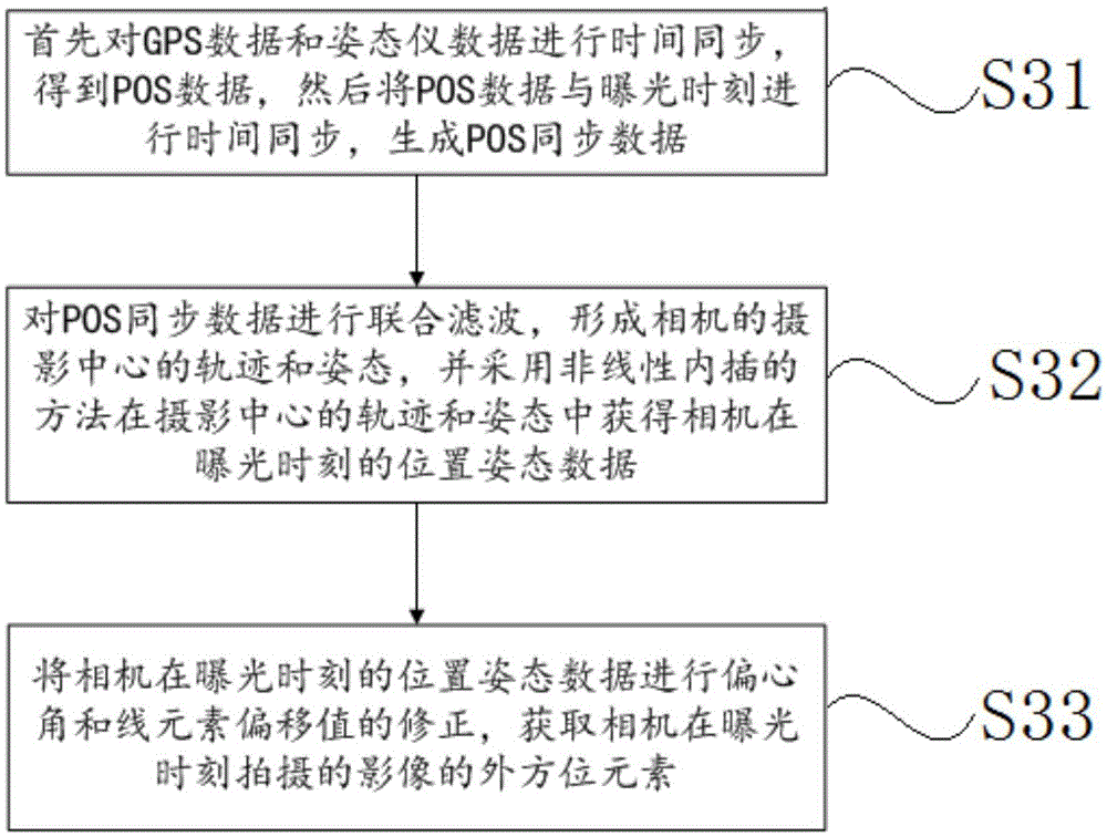
[0050] S3, the embedded computer performs synchronous and real-time calculation on the acquired GPS data and the attitude instrument data, and calculates the outer orientation element of the image taken by the camera at the pres...


PUM


Abstract

The invention relates to a real-time panoramic stitching method and a real-time panoramic stitching system for unmanned aerial vehicle images. The method comprises the following steps: shooting an aerial photography area to acquire the image of each exposure point by a camera; acquiring corresponding GPS data and attitude instrument data from a GPS (Global Positioning System) and an attitude instrument respectively; performing synchronization and real-time calculation the acquired GPS data and attitude instrument data, and calculating elements of the exterior orientation of the image shot by the camera at a preset exposure time; mapping the images which are acquired at the corresponding exposure points and are preprocessed to a panoramic image according to the elements of the exterior orientation of the camera at the preset exposure time to obtain a real-time panoramic image. According to the real-time panoramic stitching method and the real-time panoramic stitching system for the unmanned aerial vehicle images, panoramic stitching is performed on the images in real time by acquiring the image data, positioning instrument data and the GPS data, synchronizing the positioning instrument data and the GPS data and quickly calculating the positioning instrument data and the GPS data; compared with the conventional aerial photograph measurement process, time-consuming links, such as aerial triangulation, are avoided, and the data processing speed is greatly improved.

Description

technical field [0001] The invention relates to the field of UAV photogrammetry, in particular to a method and system for real-time panorama splicing of UAV images. Background technique [0002] At present, many companies at home and abroad are developing digital aerial cameras. The mature products include UCX of Microsoft Corporation, DMC of Intergraph Corporation, SWDC of Beijing Siwei Vision Company and so on. These systems are all aimed at traditional aerial photogrammetry applications, and their volume and weight are very large, requiring large aircraft to carry them. In addition, its main problem is that it only acquires data during the flight, and all data processing is done on the ground. For larger regions, data processing can take weeks or even months. Such processing efficiency is difficult to meet the requirements of data immediacy in special situations such as earthquake relief and emergency response. Contents of the invention [0003] The technical problem...

Claims


Application Information

Patent Timeline
IPC IPC(8): G01C11/00G06T3/40
CPCG01C11/00G06T3/4038
Inventor 郑顺义桂力王晓南赵丽科任关宝
Owner WUHAN UNIV
Why Eureka
Try Eureka