Rapid development method for ground surface detection software special for inertial navigation system

A technology of ground detection and inertial navigation system, applied in the direction of program control device, etc., can solve the problems of low development efficiency of ground detection software, high error rate of manual coding, manpower consumption, etc., so as to avoid repetitive coding work and avoid high error rate. , the effect of reducing workload

Inactive Publication Date: 2016-06-08
FLIGHT AUTOMATIC CONTROL RES INST
View PDF3 Cites 1 Cited by
  • Summary
  • Abstract
  • Description
  • Claims
  • Application Information

AI Technical Summary

Problems solved by technology

The disadvantage of this design method is that the ground detection software development efficiency is low, time-consuming, and manpower-intensive when the interface of the inertial navigation system has a large difference. The development efficiency of detection software is low

Method used


Image

  • Rapid development method for ground surface detection software special for inertial navigation system
  • Rapid development method for ground surface detection software special for inertial navigation system

Examples


Embodiment Construction

[0023] The present invention is described in detail below in conjunction with accompanying drawing of description, and the present invention is applied in the special-purpose ground detection software design of certain model inertial navigation system.

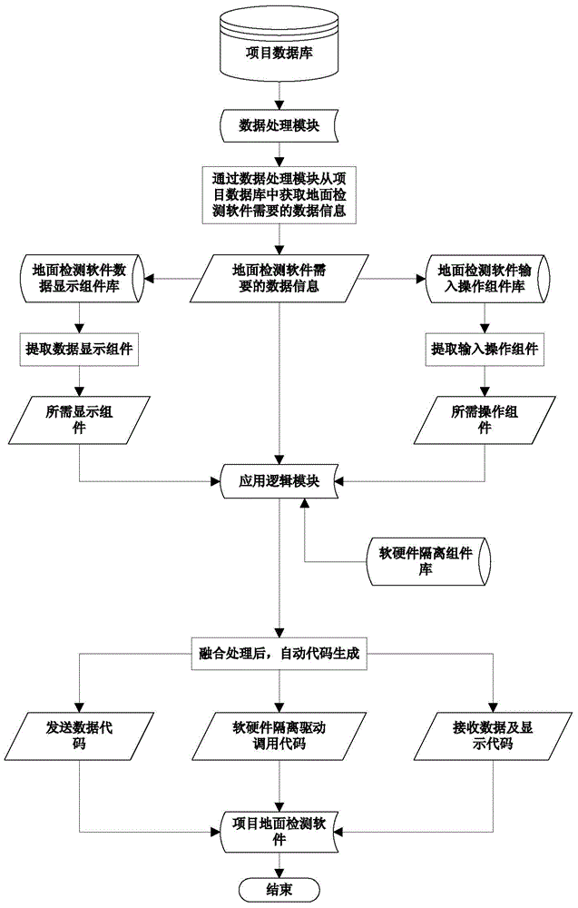
[0024] The design process of special ground detection software for a certain type of inertial navigation system is as follows: figure 1 As shown, the specific operation steps are as follows:

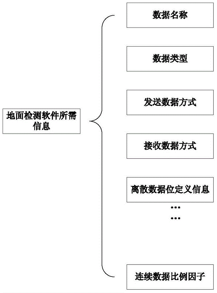
[0025] 1. Extract the data information required by the ground detection software from the project database through the data processing module, and extract the PACKET data according to the bus type, which includes the number of PACEKT, the name, length, cycle, address and other information of the PACKET;

[0026] 2. Extract DATA data from the extracted PACKET data, including DATA data name, resolution, data type, data length, high and low word data order and other information;

[0027] 3. Extract BIT data from the extracted DATA data, in...


PUM


Abstract

The invention provides a rapid development method for ground surface detection software special for an inertial navigation system. The method includes the following steps: a first step, a data processing module extracts data information required by the ground surface detection software from a project database; and a second step, an application logic module selects input operations and a data display module which are required by a project according to the extracted data information in the first step, and meanwhile, automatically generating a corresponding ground surface detection software through a software-hardware isolation component library.

Description

technical field [0001] The invention belongs to the field of research and development of special ground detection software for inertial navigation systems. Background technique [0002] The special ground detection software for the inertial navigation system is a software for testing and verifying the external interface of the inertial navigation system. It can simulate various avionics equipment cross-linked with the inertial navigation system to send data to the inertial navigation system, and can also send the inertial navigation system to other external devices. The data is displayed in real time, which has played an important role in the work of inertial navigation test verification. [0003] Due to the complexity and changeability of the external interface of the inertial navigation system, the original development steps of the inertial navigation ground detection software are as follows: first, compile the bus data sending and receiving driver according to the ICD inf...

Claims


Application Information

Patent Timeline
Patent Type & Authority Applications(China)
IPC IPC(8): G06F9/44
Inventor 杨黎张博顾戎王文全宋晓东姜敏张剑王勇
Owner FLIGHT AUTOMATIC CONTROL RES INST
Why Eureka
Try Eureka