A bridging method in gnss-ins combination

A bridging and speed technology, applied in the field of high-precision post-processing combined positioning and orientation, can solve the problems of reduced system accuracy and "sawtooth", and achieve the effect of high precision, high applicability, smooth and high-precision stable state output

Active Publication Date: 2019-01-29
WUHAN GEOSUN NAVIGATION TECH CO LTD
View PDF6 Cites 0 Cited by
  • Summary
  • Abstract
  • Description
  • Claims
  • Application Information

AI Technical Summary

Problems solved by technology

[0004] The purpose of the present invention is to provide a bridging method in the GNSS-INS combination with strong adaptability, strong stability and high precision, which solves the "sawtooth" problem in the positioning results in the normal continuous observation of GNSS and the system failure caused by the loss of GNSS lock. The problem of reduced accuracy

Method used


Image

  • A bridging method in gnss-ins combination
  • A bridging method in gnss-ins combination
  • A bridging method in gnss-ins combination

Examples


Embodiment 1

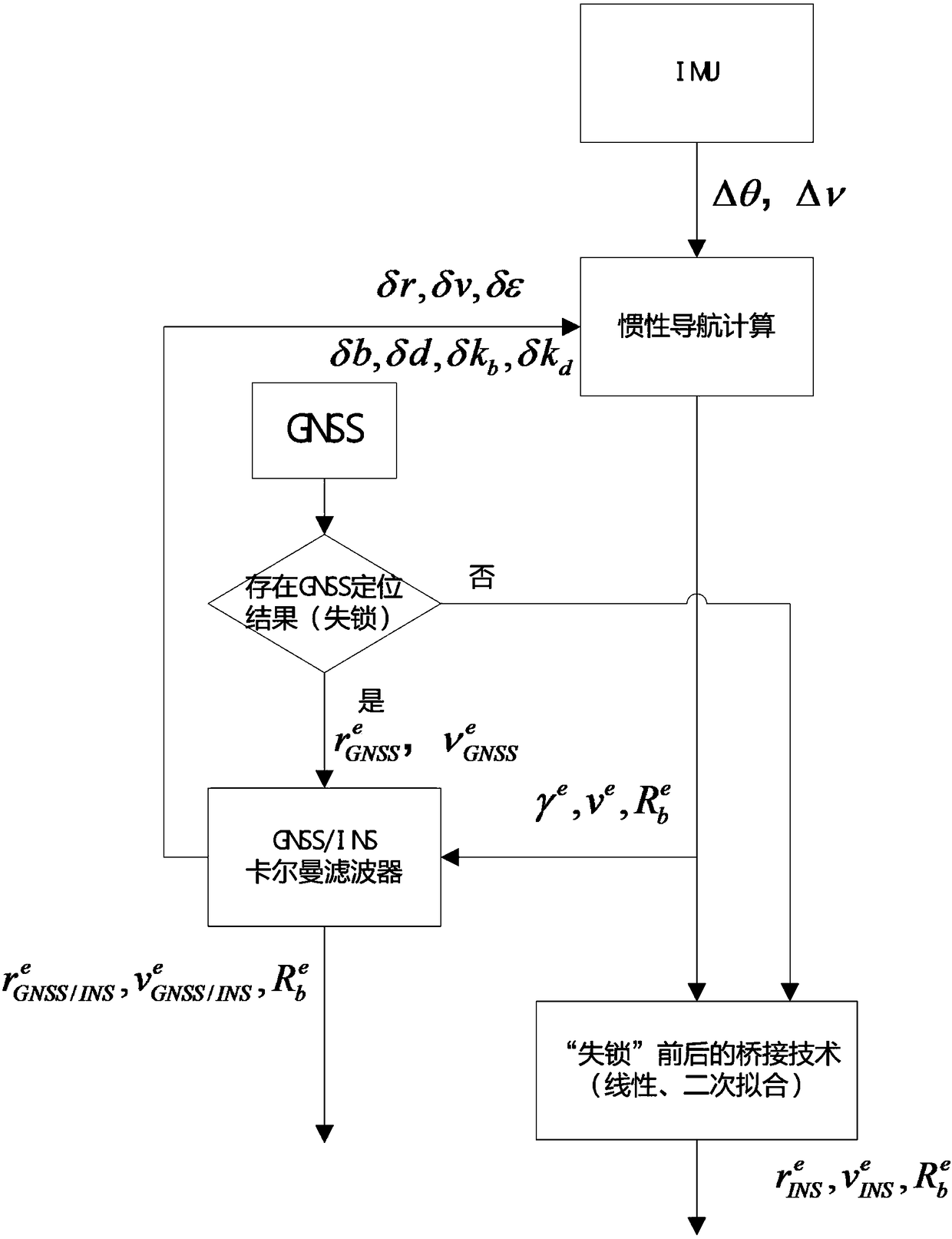
[0045] see figure 1 , in an embodiment of the present invention, a bridging method in a GNSS-INS combination specifically includes the following steps:

[0046] (1) After using the DUFCOM ambiguity search method for the carrier phase observation, the centimeter-level position value is obtained;

[0047] (2) The three-axis angular velocity output by inertial navigation and three-axis acceleration The position, velocity and attitude angle are obtained through navigation calculation under the ground-fixed system;

[0048] (3) If the GNSS satellite does not lose lock in step (1), the obtained position, velocity and the position and velocity calculated by the inertial navigation equation in step (2) form the measurement observation value in the extended Kalman filter, where The method of closed-loop correction is adopted, that is, the obtained state quantity is updated and corrected in real time to improve the accuracy of inertial navigation calculation in the next epoch;

[...


PUM


Abstract

The invention discloses a bridging method for GNSS-INS combination. The bridging method includes the steps that firstly, a position quantity at the centimeter level is figured out according to a carrier phase observed value; secondly, if no GNSS positioning result exists, INS self-contained navigation calculation is conducted; thirdly, if a GNSS positioning result exists, a GNSS-INS filter is started, the difference of position quantities obtained in the first step and the second step forms a measured value of extended Kalman filtering, compensation quantities of all state quantities are worked out, and the state quantity of a correction system is updated. The bridging method unitedly solves the problem of jittering existing in a positioning result in normal GNSS continuous observation and the problem of system precision reduction caused by GNSS lock-losing, and has the advantages of being high in adaptability, stability and precision.

Description

technical field [0001] The invention relates to the technical field of high-precision post-processing combined positioning and orientation, in particular to a bridging method in GNSS-INS combination. Background technique [0002] The US GPS, China's "Beidou" system, Russia's "GLONASS" system, and the EU's "Galileo" system are collectively called the Global Navigation Satellite System (GNSS). The inertial navigation system INS (InertialNavigation System) is based on Newtonian mechanics and does not rely on external equipment. It measures the acceleration of the carrier in the inertial coordinate system through the accelerometer, integrates the time, and calculates the rotation matrix combined with the angular velocity measured by the gyroscope. Transform into the navigation coordinate system, and then obtain the carrier's position, speed, and attitude angle of the autonomous navigation system. Satellite positioning does not produce integral errors, but it is susceptible to i...

Claims


Application Information

Patent Timeline
Patent Type & Authority Patents(China)
IPC IPC(8): G01C21/16
CPCG01C21/165
Inventor 孙红星丁学文王晖
Owner WUHAN GEOSUN NAVIGATION TECH CO LTD
Why Eureka
Try Eureka