
Three-dimensional data engine system based on geographic information

A technology of three-dimensional data and geographic information, applied in the field of geographic information, can solve the problems of difficulty in meeting the needs of comprehensive analysis, poor versatility and scalability, and difficulty in ensuring data security and efficiency, and achieve the effect of efficient data services

Active Publication Date: 2016-06-22
星际空间(天津)科技发展有限公司
View PDF4 Cites 18 Cited by
  • Summary
  • Abstract
  • Description
  • Claims
  • Application Information

AI Technical Summary

Problems solved by technology

However, most of the file system management methods currently used either divide large-scale three-dimensional spatial data into multiple planning units for separate management, which is difficult to meet the requirements of integrated management and seamless roaming; or use loose large file management methods, which is difficult to ensure data security Security and efficiency, so the use of large-scale relational database management system integrated management of three-dimensional spatial data has gradually become an inevitable choice
[0004] The integrated management of 3D spatial data above and below ground, past, present, and future requires a 3D spatial data model. Most of the existing 3D spatial data models are limited to specific professional fields, such as geological models, mine models, and surface landscape models. It is difficult to meet the needs of semantic expression, dynamic update, consistency maintenance, and comprehensive analysis of three-dimensional spatial information on the ground, surface, underground, past, present, and future.

Method used


Image

  • Three-dimensional data engine system based on geographic information
  • Three-dimensional data engine system based on geographic information
  • Three-dimensional data engine system based on geographic information

Examples


Embodiment 1

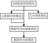
[0053] figure 1 A schematic structural diagram of a three-dimensional data engine system based on geographic information provided in this embodiment. As shown in the figure, a three-dimensional data engine system based on geographic information is composed of GIS data model module, metadata management module, database access abstraction module, geometric figure module and database access module; among them:

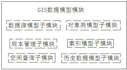
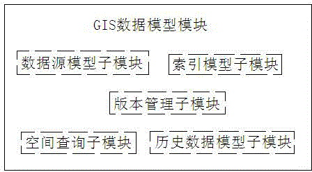
[0054] The GIS data model module defines a data model for GIS data visualization; uses an ordered coordinate set with related attributes to represent an entity object in the real world; classifies and manages entity objects of different categories; creates indexes for spatial data ;

[0055] The metadata management module is used to manage the metadata tables on which the GIS data model depends, abstracts each metadata table into a metadata object, and supports creation and storage of sub-tables of feature class data of multiple geometric types and multiple attribute ty...

Embodiment 2

[0091] figure 1 A schematic structural diagram of a three-dimensional data engine system based on geographic information provided in this embodiment. As shown in the figure, a three-dimensional data engine system based on geographic information is composed of GIS data model module, metadata management module, database access abstraction module, geometric figure module and database access module; among them:

[0092] The GIS data model module defines a data model for GIS data visualization; uses an ordered coordinate set with related attributes to represent an entity object in the real world; classifies and manages entity objects of different categories; creates indexes for spatial data ;

[0093] The metadata management module is used to manage the metadata tables on which the GIS data model depends, abstracts each metadata table into a metadata object, and supports creation and storage of sub-tables of feature class data of multiple geometric types and multiple attribute ty...


PUM


Abstract

The invention discloses a three-dimensional data engine system based on geographic information, and relates to the technical field of geographic information processing and application. The three-dimensional data engine system is characterized in that a GIS (Geographic Information System) data model module, a metadata management module, a database access abstract module, a geometric figure module and a database access module form a complete system. The system can effectively solve technical problems including two-dimensional and three-dimensional data integration management on the basis of the geographic information data, the organization, the retrieval and the analysis of spatial data, the organization and the management of a three-dimensional scene, the dispatching of mass data and the like. Meanwhile, the compatibility of a geometric data format and an OGC (Open GIS Consortium) international standard is realized, and interconversion with a geometric object defined by the OGC international standard can be realized. Different operations are carried out aiming at databases, data engines and data service of different interfaces, and therefore, data can be correctly accessed and updated. Corresponding application expansion can be carried out aiming at the change of the databases.

Description

technical field [0001] The present invention relates to the technical field of geographic information, in particular to a geographic information-based three-dimensional data engine system for the management of massive data based on geographic information, the organization, retrieval and analysis of spatial data, and the organization and management of three-dimensional entity objects. Background technique [0002] Geographic Information System (Geographic Information System or Geo-Information system, GIS) is sometimes called "geographic information system" or "resource and environmental information system". It is a specific and very important spatial information system. It is a technical system that collects, stores, manages, calculates, analyzes, displays and describes the relevant geographical distribution data in the space of the entire or part of the earth's surface (including the atmosphere) with the support of computer hardware and software systems. And this technology...

Claims


Application Information

Patent Timeline
IPC IPC(8): G06F17/30
Inventor 沈迎志江贻芳沈美岑高健蔡红周新鹤辛全波王梦
Owner 星际空间(天津)科技发展有限公司
Learn More