A healthy virtual reality walking navigation method and system

A virtual reality and walking navigation technology, applied in the field of navigation, can solve the problem that walking navigation cannot meet the personalized needs of users.

Active Publication Date: 2019-10-22
福建高阳飞动信息技术有限公司
View PDF6 Cites 0 Cited by
  • Summary
  • Abstract
  • Description
  • Claims
  • Application Information

AI Technical Summary

Problems solved by technology

At the same time, most of the existing navigation solutions focus on the shortest navigation path, or simply divide them into walking, self-driving, and bus options, making walking navigation unable to meet the individual needs of users.

Method used


Image

  • A healthy virtual reality walking navigation method and system

Examples


Embodiment Construction

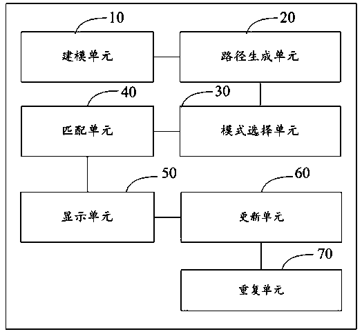
[0070] A walking navigation method for healthy virtual reality, comprising the steps of:

[0071] S1. Extract feature information of scenic spot landmarks and establish three-dimensional models of scenic spot landmarks; preset scene mode, generate mapping table of three-dimensional model of scenic spot landmarks and scene mode information; store three-dimensional model and mapping table of scenic spot landmarks in scenic spot database; The labels corresponding to various road sections are set in advance, and the weights are set for each label; the labels corresponding to the road sections and the weights of the labels are stored in the user personalized database.

[0072] The scenic spot landmark may be a famous mountain, a famous building, an artificial scenic spot, and the like. According to the characteristics of these landmarks, scene modes such as natural scenery, high-rise buildings, historical buildings, etc., can also be further divided in combination with the style of...


PUM


Abstract

The invention provides a healthy navigation method for walking based on virtual reality. The method comprises the following steps: S1, extracting characteristic information of sight spot landmarks, establishing three-dimensional models of the sight spot landmarks, S2, acquiring the value of intake calorie of a user in the day, acquiring information of navigation starting and ending points input by the user and a scene mode selected by the user, and generating preliminary navigation path sections according to the information of the navigation starting and ending points; S3, based on the scene mode selected by the user, selecting the three-dimensional models of all the sight spot landmarks in the scene mode as a candidate set through mapping; S4, screening out the three-dimensional model of a sight spot landmark matching with the length of the navigation path and the three-dimensional information of the buildings from the candidate set according to the length of the navigation path and the three-dimensional information of the buildings; S5, displaying the three-dimensional models of the sight spot landmarks, the three-dimensional information and the navigation path on VR equipment; S6, updating the weight corresponding to the label of the navigation path in an individual database of the user; and S7, repeating step S2 to step S6.

Description

technical field [0001] The invention relates to the technical field of navigation, in particular to a healthy virtual reality walking navigation method and system. Background technique [0002] Navigation equipment refers to equipment that uses a positioning system to provide route guidance for moving objects such as vehicles. Existing navigation equipment mainly utilizes a positioning system to provide navigation services for users. Specifically, the navigation device provides the user with a navigation map, in which a navigation path and an estimated time-consuming time from the current location to the destination are displayed. [0003] Virtual reality (virtual reality, VR) technology is a computer simulation system that can create and experience a virtual world. It uses a computer to generate a simulated environment, which is an interactive 3D dynamic scene and entity behavior system that combines multi-source information Simulation immerses the user in that environmen...

Claims


Application Information

Patent Timeline
Patent Type & Authority Patents(China)
IPC IPC(8): G01C21/34G06F3/01
Inventor 胡奕清
Owner 福建高阳飞动信息技术有限公司
Why Eureka
Try Eureka