Simulation GPS signal method based on software definition radio

A GPS signal, software-defined technology, applied in the field of GPS analog signals, can solve problems such as real-time control

Inactive Publication Date: 2016-08-31
EAST CHINA NORMAL UNIV
View PDF3 Cites 4 Cited by
  • Summary
  • Abstract
  • Description
  • Claims
  • Application Information

AI Technical Summary

Problems solved by technology

The existing technology can only pre-generate GPS signal data and then transmit these signals. The simulated path or fixed point is pre-designed and cannot be controlled in real time as needed.

Method used


Image

  • Simulation GPS signal method based on software definition radio
  • Simulation GPS signal method based on software definition radio

Examples


Embodiment Construction

[0019] The present invention will be further described in detail in conjunction with the following specific embodiments and accompanying drawings. The process, conditions, experimental methods, etc. for implementing the present invention, except for the content specifically mentioned below, are common knowledge and common knowledge in this field, and the present invention has no special limitation content.

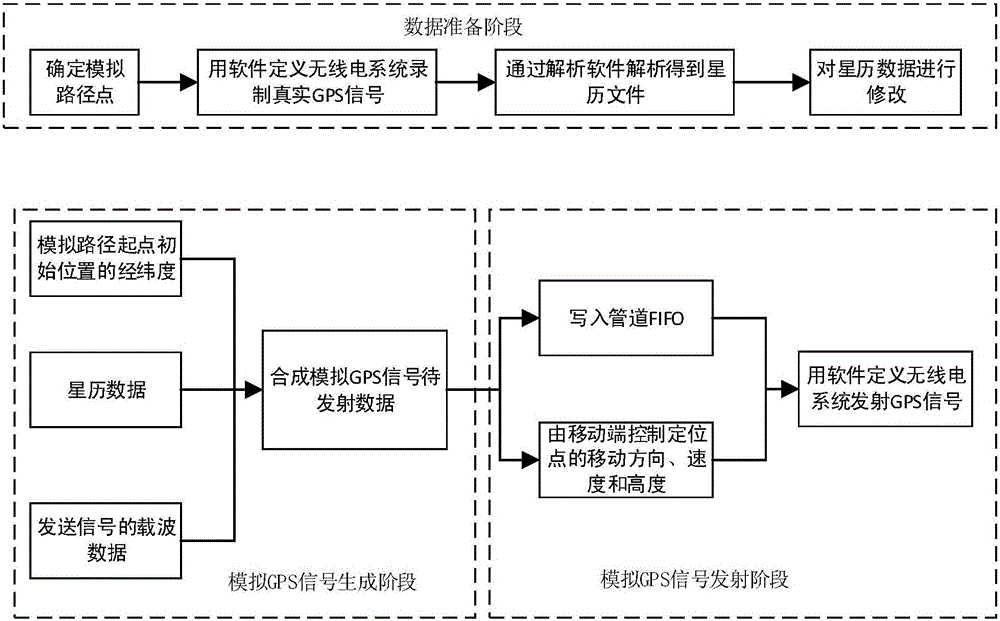
[0020] Such as figure 1 As shown, the method for simulating GPS signals based on software defined radio of the present invention comprises the following three stages:

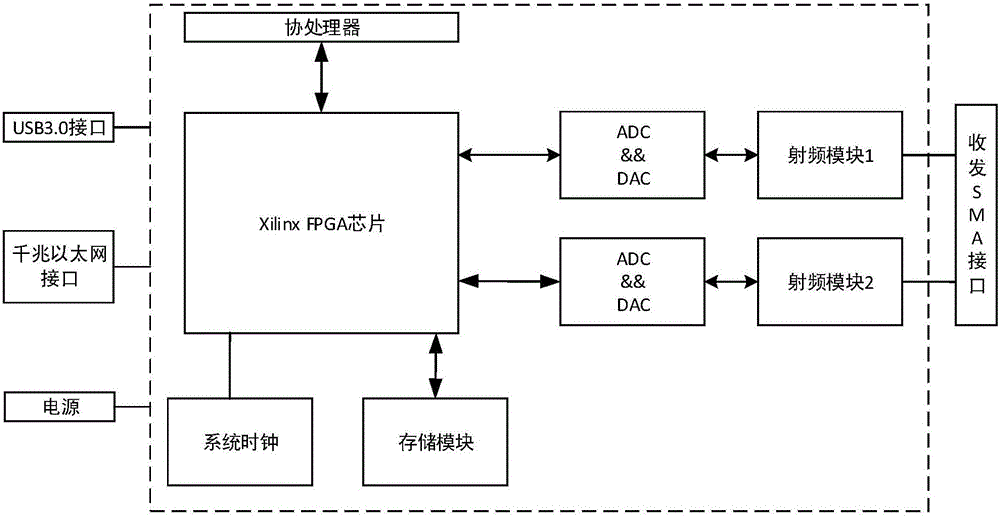
[0021] The first stage: the data preparation stage. In this stage, it is necessary to use the software defined radio system to record the real GPS signal near the starting point in the simulated path, and analyze the ephemeris data, and modify the ephemeris data if necessary. The software-defined radio system is composed of FPGA chip, digital-to-analog / analog-to-digital conversion chip, interface module, a...


PUM


Abstract

The present invention discloses a simulation GPS signal method based on a software definition radio. The method comprises: the step 1: employing an embedded mobile device to cooperating with a software definition radio system, recoding the real GPS signals close to the path starting point, and employing a parsing software to analyze the data of the GPS signals to obtain the ephemeris file thereof; the step 2: employing obtained ephemeris file to generate GPS simulation signals of the latitude and longitude of the path starting point position and the control information of the mobile terminal; and the step 3: employing the software definition radio system to emit GPS simulation signals, and furthering employing the control program installed on the embedded mobile device to control the locus of the simulation path in real time through emitting the GPS simulation signals. The simulation GPS signal method based on the software definition radio employs a mobile terminal to control the moving direction and the moving speed and height of the positioning point so as to dynamically change the locus and the simulation path.

Description

technical field [0001] The invention relates to the field of GPS analog signals in the navigation and positioning industry, in particular to a software-defined radio-based GPS signal simulation system that controls the moving direction, speed, and height of positioning points in real time through a mobile terminal. Background technique [0002] Currently, global satellite navigation systems (GNSS) include GPS in the United States, Glonass in Russia, Galileo in Europe, Beidou satellite navigation system in China, and related augmentation systems. The global navigation system is widely used in navigation and timing, and the safety of the global navigation system is also crucial. In order to better protect the safety of the navigation system, the present invention uses GPS as an example to study the method of simulating GPS signals, so as to cooperate with Good work on GPS security research. [0003] Most existing GPS signal simulation devices are expensive, technically comple...

Claims


Application Information

Patent Timeline
Patent Type & Authority Applications(China)
IPC IPC(8): G01S19/37G01S19/23
CPCG01S19/23G01S19/37
Inventor 何道敬琚小明乔银荣
Owner EAST CHINA NORMAL UNIV
Why Eureka
Try Eureka