Landform correction meter wave radar height measurement method based on broadcast automatic mutual supervisory signals

A monitoring signal and meter-wave radar technology, which is applied to radio wave measurement systems, measurement devices, radio wave reflection/reradiation, etc., can solve problems such as unsatisfactory measurement performance, and achieve low difficulty in engineering implementation and good portability , the effect of high measurement accuracy

Inactive Publication Date: 2016-09-21
XIDIAN UNIV
View PDF3 Cites 10 Cited by
  • Summary
  • Abstract
  • Description
  • Claims
  • Application Information

AI Technical Summary

Problems solved by technology

Therefore, while the synthetic steering vector super-resolution algorithm achieves excellent measurement performance, it is sensitive to the topography of the positions around the radar, and the measurement performance under complex position conditions is not ideal.

Method used


Image

  • Landform correction meter wave radar height measurement method based on broadcast automatic mutual supervisory signals
  • Landform correction meter wave radar height measurement method based on broadcast automatic mutual supervisory signals
  • Landform correction meter wave radar height measurement method based on broadcast automatic mutual supervisory signals

Examples


Embodiment Construction

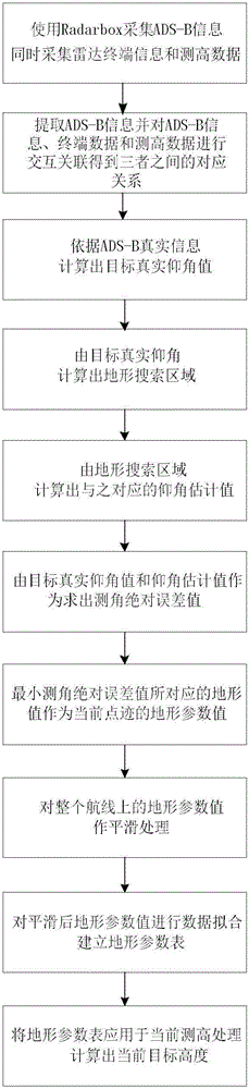
[0042] The content and effects of the present invention will be described in detail below in conjunction with the accompanying drawings.

[0043] refer to figure 1 , the present invention comprises the following steps:

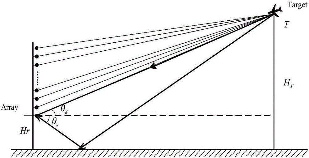
[0044] Step 1. Refer to figure 2 , set up the meter wave altimetry radar, and then install the broadcast automatic mutual surveillance signal ADS-B receiving antenna, and connect the output end of the receiving antenna to the computer equipment.

[0045] Step 2. Obtain track data.

[0046] 2.1) Collect meter wave radar data:

[0047] Collect the altimetry data of the meter wave radar from the meter wave radar altimetry board;

[0048] Collect terminal data from computer terminals;

[0049] Acquisition of secondary radar data from the broadcast automatic mutual surveillance signal ADS-B;

[0050] 2.2) Obtain track data according to the collected data:

[0051] The three kinds of data collected are interactively correlated, and according to the correspon...


PUM


Abstract

The invention discloses a terrain correction meter-wave radar altimetry method based on broadcasting automatic mutual monitoring signals, which mainly solves the problem of low precision in angle measurement and measurement in the prior art. Its implementation steps are: 1. Set up meter-wave altimetry radar and broadcast automatic mutual surveillance signal ADS‑B equipment; 2. Collect radar data, ADS‑B data and radar terminal data; 3. Obtain target elevation angle from ADS‑B data and Calculate the terrain search area; 4. Calculate the estimated value of the elevation angle according to the result of 3 and calculate the absolute error of the measured angle; 5. Obtain the value of the terrain parameter from the minimum absolute error of the measured angle, and smooth it, and then do data fitting to establish the terrain parameter Table; 6. Calculate the target elevation angle and height according to the terrain parameter table. The invention can not only compensate the height measuring error caused by terrain undulations, but also compensate the error caused by the height measuring approximate model, improve the angle measuring and measuring high precision, and can be used for three-coordinate positioning and tracking of airspace targets.

Description

technical field [0001] The invention belongs to the technical field of radar signal processing, and in particular relates to a meter-wave radar height measuring method, which can be used for three-coordinate precise positioning and tracking of airspace targets. Background technique [0002] Meter wave radar altimetry in engineering is actually to solve the angle resolution problem of two coherent echoes in one radar beam. In the actual engineering application of meter-wave radar altimetry, the DOA super-resolution algorithm is widely used. The DOA estimation methods suitable for meter-wave radar altimetry are mainly divided into the DOA estimation method based on the characteristic subspace and the synthetic steering vector maximum likelihood algorithm. SVML. in: [0003] The characteristic subspace method is to use the orthogonality between the characteristic subspace and the radar array flow pattern to calculate the signal space spectrum, and then obtain the estimated va...

Claims


Application Information

Patent Timeline
Patent Type & Authority Applications(China)
IPC IPC(8): G01S13/88
CPCG01S13/882
Inventor 陈伯孝莫鸿华李存勖杨明磊
Owner XIDIAN UNIV
Why Eureka
Try Eureka