Pedestrian navigation system three-dimensional spatial positioning method based on human/environment constraints

A pedestrian navigation and three-dimensional space technology, applied in the field of navigation and positioning, can solve the problems of low precision of MEMS sensors

Active Publication Date: 2016-10-12
BEIJING INSTITUTE OF TECHNOLOGYGY
View PDF5 Cites 31 Cited by
  • Summary
  • Abstract
  • Description
  • Claims
  • Application Information

AI Technical Summary

Problems solved by technology

However, MEMS sensors generally have low precision. When using the SINS algorithm to calculate navigation parameters, the position error caused by the acceleration error during the integration process will increase with the cube of time.

Method used


Image

  • Pedestrian navigation system three-dimensional spatial positioning method based on human/environment constraints
  • Pedestrian navigation system three-dimensional spatial positioning method based on human/environment constraints
  • Pedestrian navigation system three-dimensional spatial positioning method based on human/environment constraints

Examples


Embodiment Construction

[0056] The present invention will be further described in detail below through the specific examples, the following examples are only descriptive, not restrictive, and cannot limit the protection scope of the present invention with this.

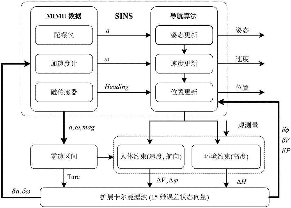
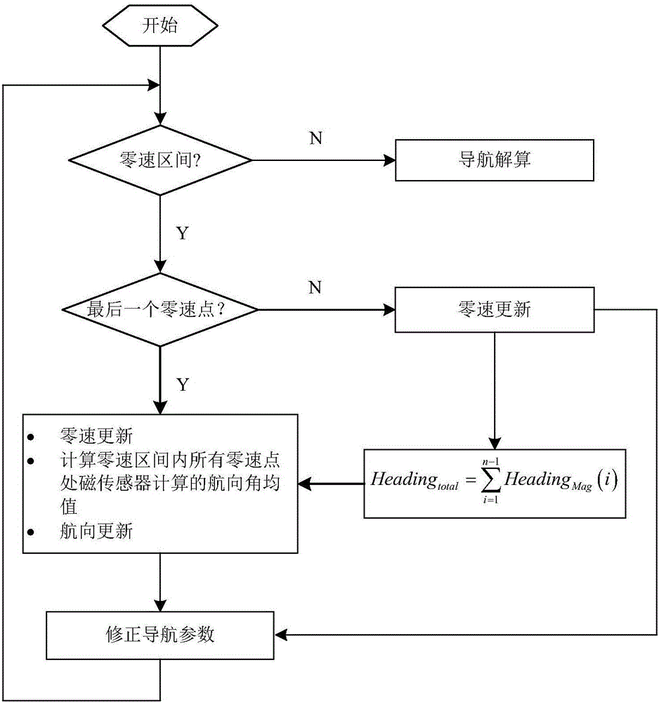
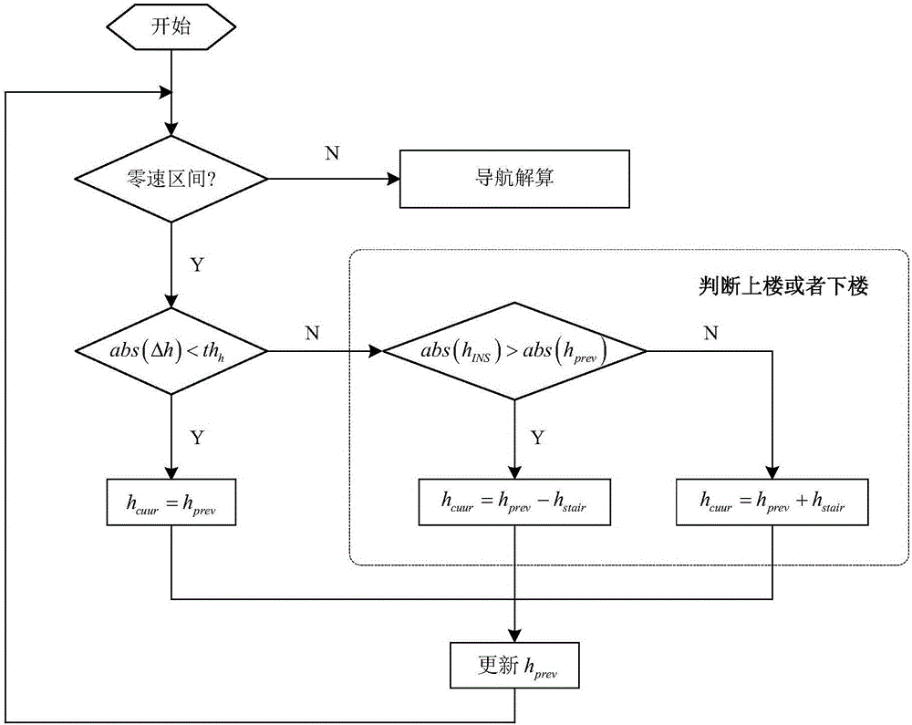
[0057] like figure 1 As shown, the present invention claims a method for three-dimensional space positioning of a pedestrian navigation system based on human body / environment constraints, and the method includes the following steps:

[0058] S101, install a MEMS (Micro-Electro-Mechanical System) inertial measurement unit on the heel of the shoe, and the MIMU coordinate axes point to the front, right, and down directions of the human body; install a pressure sensor on the heel of the sole to ensure that its sensitive axis is in the vertical direction ;

[0059] The MEMS inertial measurement unit includes a three-axis MEMS accelerometer, a three-axis MEMS gyroscope and a three-axis MEMS magnetic sensor;

[0060] S102, collecting the output d...


PUM


Abstract

The invention relates to a pedestrian navigation system three-dimensional spatial positioning method based on human / environment constraints and solves the problem with high-precision positioning of a pedestrian navigation system in a three-dimensional space, wherein the system is designed based on a low-cost MEMS (micro-electromechanical system) inertial measurement unit; data collection and strap-down navigation calculation are performed by installing the MEMS inertial measurement unit on a shoe, and zero-speed ranges in pedestrian gaits are detected in connection with data output by a pressure sensor installed on a sole. A scheme is provided based on zero speed correction in connection with pedestrian motion characteristics and ambient building characteristics, the scheme is about constraining magnetic field abnormality in zero-speed ranges and constraining SINS (ship's inertial navigation system) height channel divergence, and an extended Kalman filter is designed to correct errors in navigation calculation results, thereby enabling high-precision positioning of pedestrians in the three-dimensional space.

Description

technical field [0001] The invention belongs to the technical field of navigation and positioning, and in particular relates to a three-dimensional space positioning method for a pedestrian navigation system based on human body / environment constraints. Background technique [0002] Pedestrian navigation systems can help personnel performing tasks to locate themselves in real time and get in touch with the command center, thus greatly ensuring the safety of emergency rescue personnel in unknown environments. In addition, in large public places such as airports, theaters, underground parking lots, and modern cities with many high-rise buildings, a pedestrian navigation system with high precision and strong real-time performance can effectively help pedestrians to locate themselves and find targets. However, existing satellite positioning systems cannot work normally in urban canyons, indoors and other environments where satellite signals are limited or fail, so continuous auto...

Claims


Application Information

Patent Timeline
Patent Type & Authority Applications(China)
IPC IPC(8): G01C21/16
CPCG01C21/165
Inventor 田晓春韩勇强陈家斌谢玲李楠
Owner BEIJING INSTITUTE OF TECHNOLOGYGY
Why Eureka
Try Eureka