Multi-rule algorithm-based remote sensing data downscaling method

A technology of remote sensing data and downscaling, which is applied in the direction of electrical digital data processing, special data processing applications, calculations, etc., and can solve problems such as low resolution

Active Publication Date: 2016-10-12
ZHEJIANG UNIV
View PDF3 Cites 21 Cited by
  • Summary
  • Abstract
  • Description
  • Claims
  • Application Information

AI Technical Summary

Problems solved by technology

However, the original resolution of the TRMM satellite is relatively low (spatial resolution is 0.25°, about 25km), which has certain limitations and deviations in predicting regional-scale precipitation. Therefore, it is necessary to improve the spatial resolution of TMPA data to obtain Higher resolution precipitation measurements

Method used


Image

  • Multi-rule algorithm-based remote sensing data downscaling method
  • Multi-rule algorithm-based remote sensing data downscaling method
  • Multi-rule algorithm-based remote sensing data downscaling method

Examples


Embodiment Construction

[0026] The present invention will be further described below in conjunction with specific examples.

[0027] China was selected as the research area, and the high-precision forecasting and cartography of the monthly rainfall from 2008 to 2012 was carried out, and finally the precipitation prediction value with a spatial resolution of 1 km was obtained.

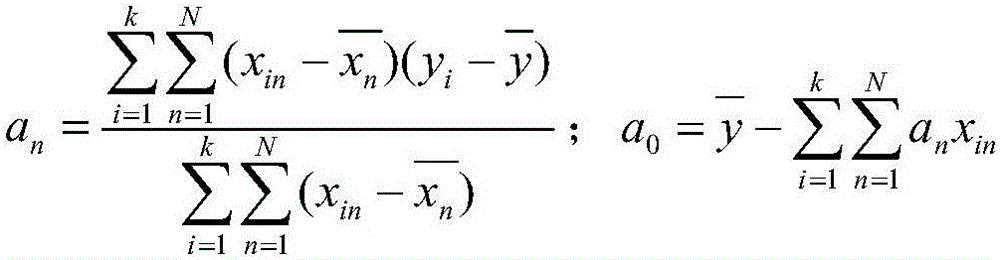
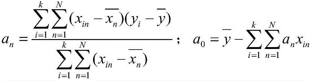
[0028] Step 1) Data acquisition: Obtain TMPA 3B43 v7 precipitation data, MODIS satellite remote sensing image data and ASTERGDEM satellite remote sensing image data in the area to be measured, and collect daily precipitation observations at ground observation stations in the area to be measured; the MODIS satellite remote sensing image The data includes MOD11A2 data products and MOD13A2 data products; the spatial resolution of TMPA 3B43 v7 precipitation data is 0.25°×0.25°, and the temporal resolution is month; the spatial resolution of the ASTER GDEM satellite remote sensing image data is 90m; the The MODIS satellite remote s...


PUM


Abstract

The invention discloses a multi-rule algorithm-based remote sensing data downscaling method. The method comprises the following steps: firstly aggregately calculating 9 data, such as a vegetation index, a digital elevation model, a daytime land surface temperature, a night land surface temperature, a terrain humidity index, a gradient, a land surface roughness, a land surface reflectance and a valley bottom flat index, of environment variable factors in 1km into 25km to serve as independent variables; carrying out modelling by taking TMPA 3B43 v7 rainfall data corresponding to a 25km resolution as dependent variables; and applying the established model onto 1km environment variable factors of corresponding geographic areas, so as to finally obtain high-precision rainfall prediction data in 1km. According to the multi-rule algorithm-based remote sensing data downscaling method, the rainfall prediction value of the 1km space resolution is finally obtained. The method is relatively high in prediction precision, simple, convenient and feasible.

Description

technical field [0001] The invention relates to a method for downscaling meteorological satellite precipitation data, in particular to a method for downscaling TMPA 3B43 v7 remote sensing data based on a multi-rule algorithm. technical background [0002] Precipitation plays an important role in the fields of hydrology, meteorology, ecology, and agricultural research, especially as one of the main driving forces of global-scale material and energy exchange. Surface observation station is a widely used means of precipitation measurement, and has the characteristics of high precision and mature technology. However, the precipitation monitored by surface observation stations only represents the precipitation at a certain distance from the surface observation stations and surrounding areas, so it is difficult to express the characteristics of precipitation distribution over a large area, especially in plateau areas where the network density of surface observation stations is spa...

Claims


Application Information

Patent Timeline
Patent Type & Authority Applications(China)
IPC IPC(8): G06F19/00
CPCG16Z99/00Y02A90/10
Inventor 史舟马自强梁宗正吕志强
Owner ZHEJIANG UNIV
Why Eureka
Try Eureka