Verifying method and apparatus based on POS equipment and digital aerial survey camera

An aerial survey camera and verification method technology, applied in the field of measurement and remote sensing, can solve the problems of no verification method, system integration error, etc.

Inactive Publication Date: 2016-10-26
HENAN UNIV OF URBAN CONSTR +2
View PDF2 Cites 10 Cited by
  • Summary
  • Abstract
  • Description
  • Claims
  • Application Information

AI Technical Summary

Problems solved by technology

[0015] At present, there is no effective verification method for the system integration errors introduced by the integration of POS equipment and digital aerial survey cameras

Method used


Image

  • Verifying method and apparatus based on POS equipment and digital aerial survey camera
  • Verifying method and apparatus based on POS equipment and digital aerial survey camera
  • Verifying method and apparatus based on POS equipment and digital aerial survey camera

Examples


Embodiment Construction

[0072] Embodiments of the present invention will be described in detail below in conjunction with the accompanying drawings.

[0073] It should be clear that the described embodiments are only some of the embodiments of the present invention, not all of them. Based on the embodiments of the present invention, all other embodiments obtained by persons of ordinary skill in the art without creative efforts fall within the protection scope of the present invention.

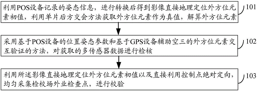
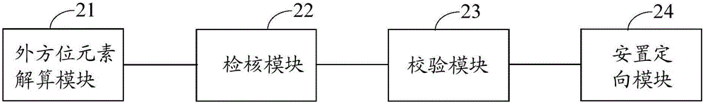
[0074] figure 1 It is a schematic flow chart of a verification method based on POS equipment and a digital aerial survey camera in an embodiment of the present invention, as figure 1 As shown, the method of this embodiment may include:

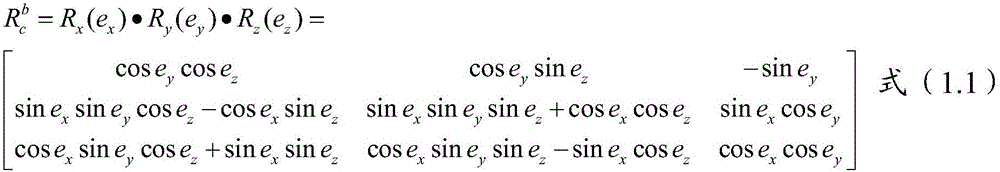
[0075] Step 101, using the posture information recorded by the POS device, after conversion, the initial value of the outer orientation element of the direct geolocation of the image is obtained, and the outer orientation element is obtained as the true value by using the single-chi...


PUM


Abstract

Embodiments of the invention disclose a verifying method and apparatus based on POS equipment and digital aerial survey camera, related to measurement and remote sensing technology and capable of effectively verifying system integration errors. The verifying method based on POS equipment and digital aerial survey camera comprises: using POS equipment to record attitude information, converting to obtain image direct geographical positioning exterior orientation element initial value, acquiring exterior orientation elements as true values by using a single-photograph resection method, and resolving exterior orientation elements; validating acquired multi-sensor data by using a cross-validation method of POS equipment-based positional attitude parameters and GPS equipment-supported aerotriangulation exterior orientation elements; using the image direct geographical positioning exterior orientation element initial value and directly using control point absolute orientation to evenly acquire and validate off-site surveillance check points for verification. The invention is applied to verification of exterior orientation elements.

Description

technical field [0001] The invention relates to measurement and remote sensing technology, in particular to a verification method and device based on POS equipment and a digital aerial survey camera. Background technique [0002] Inertial Measurement Unit (IMU, Inertial Measurement Uint) / DGPS, Differential Global Positioning System (DGPS, Differential Global Positioning System) assisted aerial photogrammetry technology is an emerging technology in the world. various fields of remote sensing. The IMU / DGPS system has become the necessary equipment for digital aerial cameras and airborne laser scanning systems. At present, through the installation of positioning and orientation system (POS, Position and Orientation System) equipment in the IMU / DGPS system, an integrated aerial remote sensing system can be formed, which can directly measure the attitude parameters of the IMU / DGPS system, and through joint processing of IMU and DGPS data , which can quickly obtain the high-prec...

Claims


Application Information

Patent Timeline
Patent Type & Authority Applications(China)
IPC IPC(8): G01C25/00
CPCG01C25/00G01C25/005
Inventor 王超李军杰焦禄霄张鹏飞王丽媛杨保杨春秦江涛
Owner HENAN UNIV OF URBAN CONSTR
Why Eureka
Try Eureka