Image identification automobile live-action navigation device and method

An image recognition and navigation device technology, applied in navigation, surveying devices, surveying and navigation, etc., can solve the problems of being unable to remind users to drive or park, have no expansion function, and cannot judge traffic signs of variable lanes, etc., to achieve increased New features, the effect of increasing user experience

Inactive Publication Date: 2016-11-09
JIANGSU UNIV
View PDF5 Cites 27 Cited by
  • Summary
  • Abstract
  • Description
  • Claims
  • Application Information

AI Technical Summary

Problems solved by technology

Traditional driving recorders generally record the video images and sounds of the whole process of car driving, without other extended functions; traditional car navigation devices generally use built-in or network maps combined with GPS positioning technology, and use map display and route marking methods for car navigation , without combining the images collected by the driving recorder for real-scene navigation; some car real-scene navigation devices have

Method used


Image

  • Image identification automobile live-action navigation device and method
  • Image identification automobile live-action navigation device and method
  • Image identification automobile live-action navigation device and method

Examples


Example Embodiment

[0074] Embodiment 1: Car real-time navigation daytime scene

[0075] Follow the steps in sequence by the car driving route

[0076] Figure 4 The image processing steps of the shown frame:

[0077] GPS positioning module 3 extracts the longitude and latitude information of the car driving;

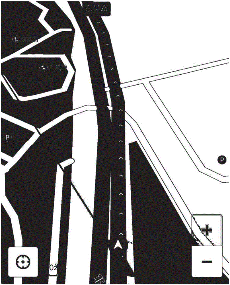
[0078] The map management module 5 provides information such as image 3 The relevant road information of the vehicle driving area shown;

[0079] The path planning module 4 provides a prompt for the car to go straight at the previous intersection according to the longitude and latitude information of the car driving, related road information and path information required to reach the destination;

[0080] The video analysis module 1 collects real-time video information of the car running, analyzes and extracts the video key frames, and stores them as Figure 4 The key frame image file shown;

[0081] The image recognition module 2 analyzes the key frame image file and analyzes that the current moment...

Example Embodiment

[0112] Embodiment 2: Car real-life navigation with variable lane scene;

[0113] Carry out the following steps in sequence by the car driving route;

[0114] Picture 12 The image processing steps of the shown frame:

[0115] GPS positioning module 3 extracts the longitude and latitude information of the car driving;

[0116] The map management module 5 provides relevant road information of the car driving area according to the latitude and longitude information of the car driving;

[0117] The path planning module 4 provides a prompt for the car to go straight at the previous intersection according to the longitude and latitude information of the car driving, related road information and path information required to reach the destination;

[0118] The video analysis module 1 collects real-time video information of the car running, analyzes and extracts the video key frames, and stores them as Picture 12 The key frame image file shown;

[0119] The image recognition module 2 analyzes the...

Example Embodiment

[0132] Example 3: U-turn scene of car navigation

[0133] Follow the steps in sequence by the car driving route

[0134] Figure 16 The image processing steps of the shown frame:

[0135] GPS positioning module 3 extracts the longitude and latitude information of the car driving;

[0136] The map management module 5 provides relevant road information of the car driving area according to the latitude and longitude information of the car driving;

[0137] The path planning module 4 provides a prompt for the car to go straight at the previous intersection according to the longitude and latitude information of the car driving, related road information and path information required to reach the destination;

[0138] The video analysis module 1 collects real-time video information of the car running, analyzes and extracts the video key frames, and stores them as Figure 16 The key frame image file shown;

[0139] The image recognition module 2 analyzes the key frame image file and analyzes that...


PUM


Abstract

The invention discloses an image identification automobile live-action navigation device and method. The device comprises a video analysis module, an image identification module, a GPS (global positioning system) module, a route planning module, a map management module and a live-action navigation management module, wherein the video analysis module is connected with the image identification module, and the live-action navigation management module is respectively connected with the image identification module, the GPS module, the map management module and the route planning module. Automobile navigation equipment provides map display and route marking, images are identified according to images acquired by an automobile data recorder, particularly, traffic signs of variable lanes are identified, a user is reminded of selecting turning lanes or direct-through lanes when approaching an intersection and reminded of driving or parking according to actual traffic signal conditions, and live-action navigation is realized. The new function of automobile navigation is added, and user experience is enhanced.

Description

Technical field [0001] The invention belongs to the technical field of automobile control, and in particular relates to an image recognition vehicle real-time navigation device and method. Background technique [0002] With the popularization and development of digital camera technology, GPS positioning technology and wireless Internet, related car navigation equipment, driving recorders and other car auxiliary equipment have 1080P or higher resolution video capture capabilities, centimeter-level positioning GPS, stable 100Mbps wireless transmission rate. The traditional driving recorder generally records the video images and sounds of the whole process of the car driving, without other extended functions; the traditional car navigation equipment generally uses built-in or network map method combined with GPS positioning technology, and uses map display and route marking methods for car navigation , There is no real scene navigation combined with the images collected by the driv...

Claims


Application Information

Patent Timeline
IPC IPC(8): G01C21/34
CPCG01C21/3446
Inventor 江浩斌陈潇君江晓明李康飞李灵芝周佳琳兰豪
Owner JIANGSU UNIV
Why Eureka
Try Eureka