Waterlogging-risk-evaluation-based low-rainwater-impact development planning method

A technology of low-impact development and risk assessment, which is applied in the field of rainwater low-impact development planning based on waterlogging risk assessment, can solve problems such as blind construction, and achieve the effects of saving investment, improving scientificity and effectiveness, and reasonable urban planning

Inactive Publication Date: 2016-11-23
GUANGDONG UNIV OF TECH
View PDF1 Cites 11 Cited by
  • Summary
  • Abstract
  • Description
  • Claims
  • Application Information

AI Technical Summary

Problems solved by technology

[0004] The technical problem to be solved by the present invention is to overcome the planning of laying out low-impact development rainwater facilities in the prior art without based on the actual regional hydrological conditions of the city, the nature of the underlying surface, the available space, the dev

Method used


Image

  • Waterlogging-risk-evaluation-based low-rainwater-impact development planning method
  • Waterlogging-risk-evaluation-based low-rainwater-impact development planning method
  • Waterlogging-risk-evaluation-based low-rainwater-impact development planning method

Examples


Embodiment 1

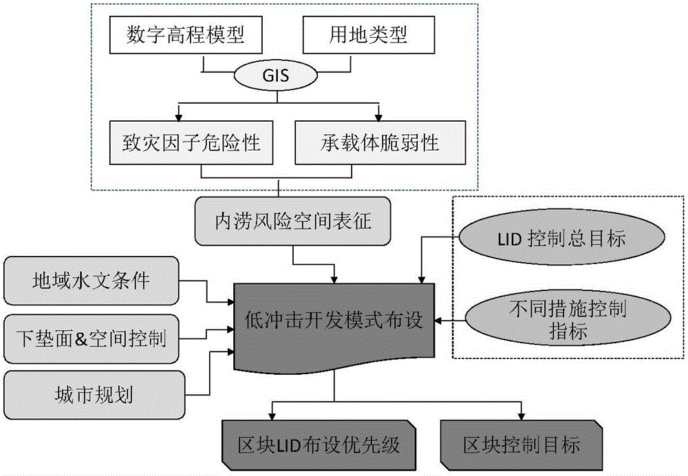
[0038] A rainwater low-impact development planning method based on waterlogging risk assessment, including the following steps:

[0039] S1: Quickly assess the waterlogging risk in the planning area. Specifically: use the GIS grid hydrological modeling method to quickly assess the waterlogging risk in the planning area.

[0040] The specific steps are:

[0041] ① With the help of GIS operating platform, using raster structure and vectorized data, the digital elevation model is used to analyze the surface flow direction of the planning area and identify the watershed.

[0042] ② In GIS, a simplified method is used to approximate and simulate the hydrological characteristics of the watershed in the planning area, such as runoff pathways, urban low-lying waterlogging points, etc., so as to obtain a rough description of the risk of waterlogging hazards.

[0043] ③ The vulnerability assessment of the carrier of the planning area is mainly based on the primary GIS or electronic ma...

Embodiment 2

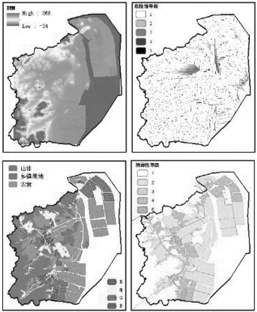
[0049] A rainwater low-impact development planning method based on waterlogging risk assessment, using the GIS grid hydrological modeling method to quickly assess the waterlogging risk in the H planning area. The input data and assessment results of hazards of hazards and vulnerability of bearing bodies in this planning area are shown in figure 2 , the assessment result is to obtain the division of five standardized grades by standardizing or normalizing the data of the hazard of the hazard and the actual value of the carrier's vulnerability.

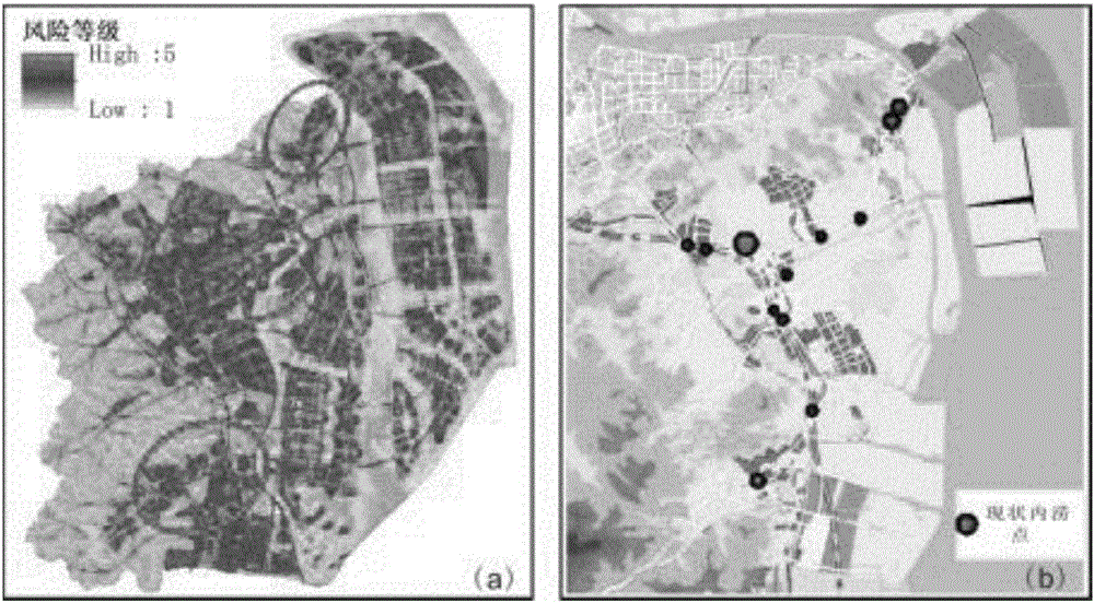
[0050] 1. For the calculated waterlogging risk level, see image 3 a, Used to show the spatial distribution of high, medium and low risk areas of waterlogging in this area. Areas with a high waterlogging risk level represent a higher possibility of being affected by waterlogging disasters, and once a disaster occurs, the losses will be greater. It can be seen from the risk map that the study area has the lowest waterlogging risk in t...


PUM


Abstract

The invention discloses a rainwater low-impact development planning method based on waterlogging risk assessment, which includes the following steps: S1: quickly assessing the waterlogging risk in the planning area; S2: according to the regional hydrological characteristics of the planning area, the nature of the underlying surface, and the available space , urban planning scheme, development intensity specification, and waterlogging risk determine the priority utility function equation of the planning area, determine the priority of low-impact development and deployment in the planning area, and then sort and judge the suitability of low-impact deployment; S3: According to the The low-impact development priority class divides the planning area into several unit blocks, and assigns the overall target of runoff coefficient control in the planning area to each of the unit blocks until the total runoff coefficient determined by the weighted calculation of each unit block satisfies the runoff coefficient control of the planning area. The overall goal; S4: Draw the spatial layout map of runoff coefficient control in the planning area to provide decision support for low-impact development planning.

Description

technical field [0001] The invention relates to the technical field of rainwater engineering planning, in particular to a rainwater low-impact development planning method based on waterlogging risk assessment. Background technique [0002] At present, there are different regulations on the control objectives of low-impact development at home and abroad, mainly including the control of total annual runoff, total rainfall and comprehensive runoff coefficient. Regarding the planning method of low-impact rainwater development, Chinese patent document 201510563320.2 discloses a planning method and device for low-impact rainwater development, which mainly changes the annual rainwater runoff coefficient of the plot and the peak runoff in the planning area by adding rainwater settings to the planning area In order to realize the low-impact development planning of rainwater, the process is cumbersome and consumes a lot of cost, manpower and material resources, and there is no block l...

Claims


Application Information

Patent Timeline
IPC IPC(8): G06Q10/06G06Q50/26
CPCG06Q10/0637G06Q50/26
Inventor 周倩倩许明华许苗苗
Owner GUANGDONG UNIV OF TECH
Why Eureka
Try Eureka