A digital map drawing system with integrated production and management

A digital map and map technology, applied in geographic information databases, structured data retrieval, etc., can solve the problems of disconnection between database management systems and inability to promote each other, and achieve the effect of improving operation efficiency and improving production and management level.

Active Publication Date: 2019-10-01
西安测绘研究所
View PDF5 Cites 1 Cited by
  • Summary
  • Abstract
  • Description
  • Claims
  • Application Information

AI Technical Summary

Problems solved by technology

[0006] In view of the above situation, in order to overcome the defects of the existing system, the purpose of the present invention is to provide a digital map drawing system with integrated production and management, which can effectively solve the problem of the interaction between the front-end production operation processing system and the back-end database management system of the digital map drawing system. Problems such as disconnection and inability to promote each other, support the realization of database-driven map drawing and dynamic update

Method used


Image

  • A digital map drawing system with integrated production and management
  • A digital map drawing system with integrated production and management
  • A digital map drawing system with integrated production and management

Examples


Embodiment

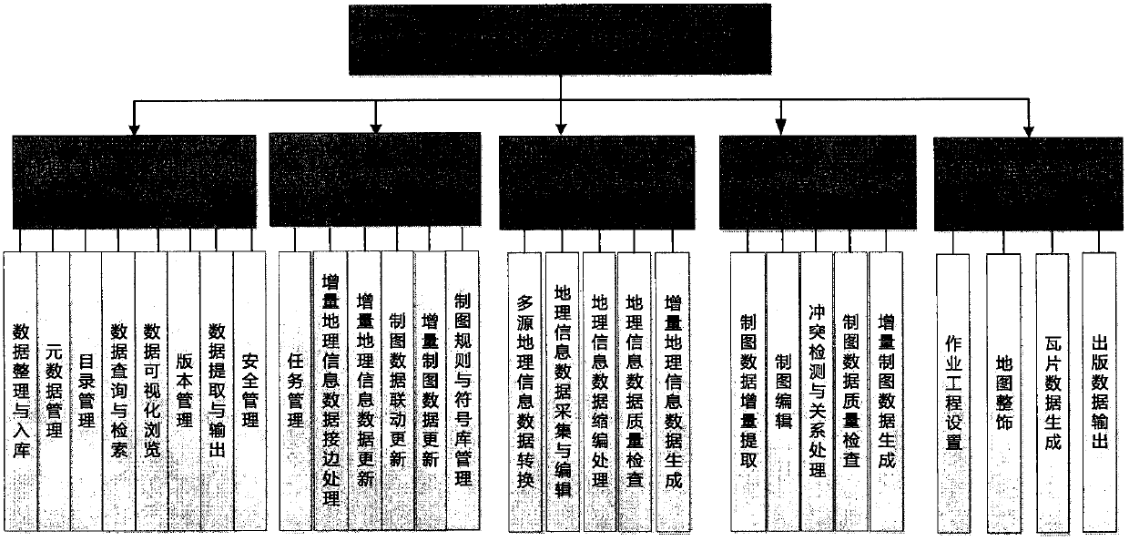
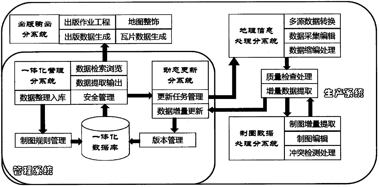
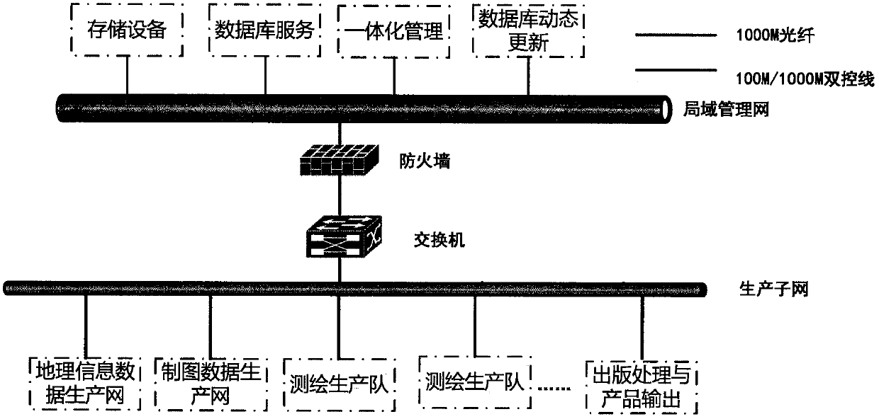
[0089] Based on the above design scheme, a digital map drawing system with integration of production and management was developed. The network structure of the system is attached image 3 As shown, it is divided into a two-level deployment mode of management units for data management and production units for data production. The network consists of two levels of networks: the local area management network of the management unit and the production subnet of the production unit. The local area management network is constructed by the management unit to realize data storage management, integrated management of geographic information and map drawing data, and dynamic update of the database; the production subnet of the production unit relies on the existing production network to maintain and manage data The connectivity of the network also provides a network platform and system equipment environment for the update production of geographic information and cartographic data, publica...


PUM


Abstract

The invention relates to map drawing, especially a digital map drawing system with integrated production and management among digital maps and GIS (Geographic Information System, the same below), which can effectively solve the problem of the front-end production operation processing system and the back-end of the digital map drawing system. The database management systems are disconnected from each other and cannot promote each other, and support the realization of database-driven map drawing and dynamic update. The technical solution is to divide the digital map drawing system into two categories and five subsystems: one is the management terminal , including the integrated management of geographic information and cartography data and the dynamic database update subsystem, which performs incremental warehousing and updating of data submitted by production units, data distribution, and database maintenance and management tasks; the second is the production end, including geographic information processing, Cartographic data processing and publishing processing and product output subsystems perform tasks such as geographic information data production update and map drawing and quality inspection. The present invention can effectively integrate geographic information and map drawing data. Production and management level.

Description

[0001] 1. Technical field [0002] The invention relates to map drawing, in particular to a digital map drawing system with integrated production and management among digital maps and GIS (Geographic Information System, the same below). [0003] 2. Background technology [0004] The current digital map drawing system is generally only for the front-end production operation processing system, which is relatively separated from the back-end database management system, that is, the system is only responsible for the production and processing of geographic information and map drawing, but not for data management and update. The limitations of this production and management model are: the production of the front-end digital map drawing system is out of touch with the management and update of the back-end database system, and cannot promote each other, a virtuous circle, and cannot support database-driven map drawing and dynamic updates. [0005] 3. Contents of the invention [0006...

Claims


Application Information

Patent Timeline
Patent Type & Authority Patents(China)
IPC IPC(8): G06F16/29
Inventor 安晓亚刘平芝金澄王峰杨云徐道柱焦洋洋
Owner 西安测绘研究所
Why Eureka
Try Eureka