A Method for Detection of Regions of Interest in Optical Remote Sensing Images

A technology for optical remote sensing images and regions of interest, applied in the field of remote sensing image processing, can solve the problems of poor integrity of regions of interest, sensitive distribution of regions of interest, high computational complexity, etc. Structural Information Ignoring, Effect of High Computational Efficiency

Active Publication Date: 2019-07-26
BEIJING INSTITUTE OF TECHNOLOGYGY
View PDF8 Cites 2 Cited by
  • Summary
  • Abstract
  • Description
  • Claims
  • Application Information

AI Technical Summary

Problems solved by technology

At present, most of the ROI detection algorithms inspired by visual saliency are based on pixel processing, which has high computational complexity and cannot reasonably and efficiently use the spatial structure information of optical remote sensing images. The integrity of the ROI obtained is poor. Regional distribution sensitivity and other issues

Method used


Image

  • A Method for Detection of Regions of Interest in Optical Remote Sensing Images
  • A Method for Detection of Regions of Interest in Optical Remote Sensing Images
  • A Method for Detection of Regions of Interest in Optical Remote Sensing Images

Examples


Embodiment Construction

[0051] The present invention will be described in detail below with reference to the accompanying drawings and examples.

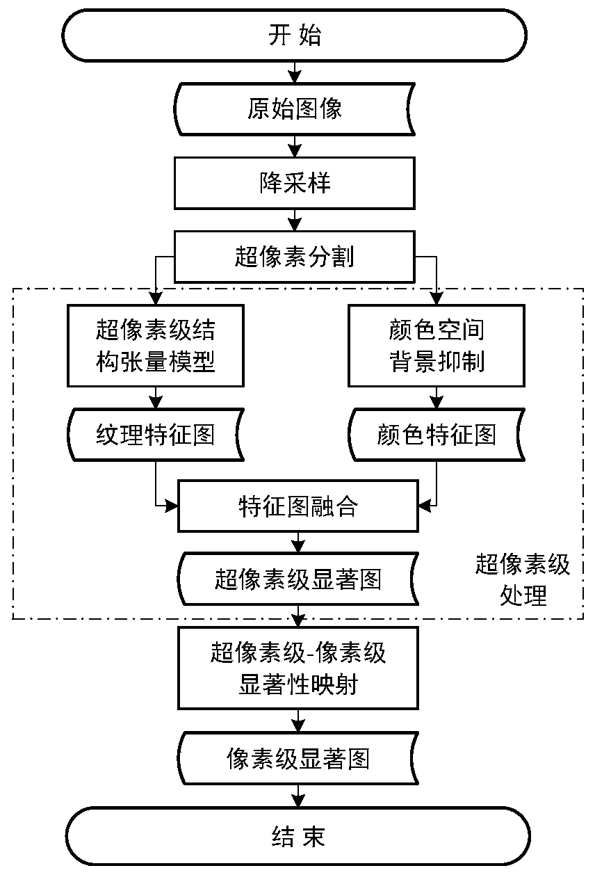
[0052] The invention provides a method for detecting a region of interest in an optical remote sensing image. The method is a coarse-to-fine detection process inspired by human visual search, and is applied to the detection of a region of interest in a high-resolution optical remote sensing image. Such as figure 1 As shown, the original image is first down-sampled, and the result of the down-sampling is subjected to superpixel segmentation. Based on the above operations, the high-resolution image is converted into a coarser-scale image. Then, on the generated coarse-scale image, the structure tensor and The color space background suppression technique obtains the superpixel-level texture feature map and color feature map respectively. Then, the superpixel-level saliency map at the original resolution scale is obtained through feature map fusion and upsamp...


PUM


Abstract

The invention discloses a method for detecting a region of interest in an optical remote sensing image, which is applied to detecting a region of interest in a high-resolution optical remote sensing image. By processing the superpixel-level image, and then performing superpixel-level to pixel-level saliency mapping, a pixel-level saliency map is obtained, and the accurate description of the region of interest can be quickly positioned from the coarse scale to the fine scale. This method first down-samples the original image, and then performs superpixel segmentation. Based on the above operations, the high-resolution image is converted into a coarse-scale image, and then, on the generated coarse-scale image, the structure tensor and color space background suppression technology are used. The texture feature map and color feature map at the superpixel level are obtained respectively. Then, the superpixel-level saliency map at the original resolution scale is obtained through feature map fusion and upsampling interpolation. Finally, through the superpixel-level to pixel-level saliency mapping, the pixel-level saliency map is obtained, and the pixel-level accurate description of the region of interest is completed.

Description

technical field [0001] The invention belongs to the technical field of remote sensing image processing, and in particular relates to a method for detecting regions of interest in optical remote sensing images based on hierarchical saliency analysis from superpixel level to pixel level. Background technique [0002] Region of interest detection in remote sensing images is one of the applications of remote sensing image analysis and information extraction. With the rapid development of remote sensing technology, the spatial resolution of remote sensing images has become higher and higher, the description of the scene has become more refined, and the amount of data to be processed has also increased. Extracting the urban area and the area to be built in the remote sensing scene as the area of ​​interest can help the land and resources department to count the distribution of urban areas, analyze the growth trend, and formulate development plans. The area of ​​interest can help ...

Claims


Application Information

Patent Timeline
Patent Type & Authority Patents(China)
IPC IPC(8): G06K9/32G06T3/40G06T5/50G06T7/00G06T7/40
CPCG06T3/4023G06T5/50G06T2207/10032G06T2207/30181G06V10/25
Inventor 陈禾杜彬马龙买志宏铁雯婕陈亮龙腾
Owner BEIJING INSTITUTE OF TECHNOLOGYGY
Why Eureka
Try Eureka