High-resolution remote sensing image road information extraction method

A technology of remote sensing images and road information, which is applied in the direction of instruments, character and pattern recognition, computer components, etc., can solve the problems such as the road information effect is not very ideal, and achieve excellent leveling performance, strong adhesive force, and elongation at break high rate effect

Inactive Publication Date: 2017-01-04
INST OF REMOTE SENSING & DIGITAL EARTH CHINESE ACADEMY OF SCI
View PDF1 Cites 26 Cited by
  • Summary
  • Abstract
  • Description
  • Claims
  • Application Information

AI Technical Summary

Problems solved by technology

However, due to the influence of image noise, "same object with same spectrum" and "same object with different spectrum" phenomenon, as well as complex road conditions, the effect of using these two methods alone to extract road information is not very satisfactory.
[0005] In terms of road extraction, although some existing methods have achieved certain results, it is found that various methods have their own shortcomings, which need to be improved and improved urgently.

Method used


Image

  • High-resolution remote sensing image road information extraction method
  • High-resolution remote sensing image road information extraction method
  • High-resolution remote sensing image road information extraction method

Examples


Embodiment

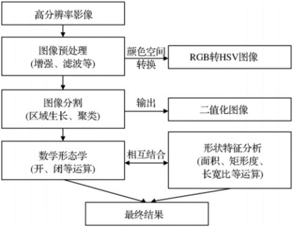
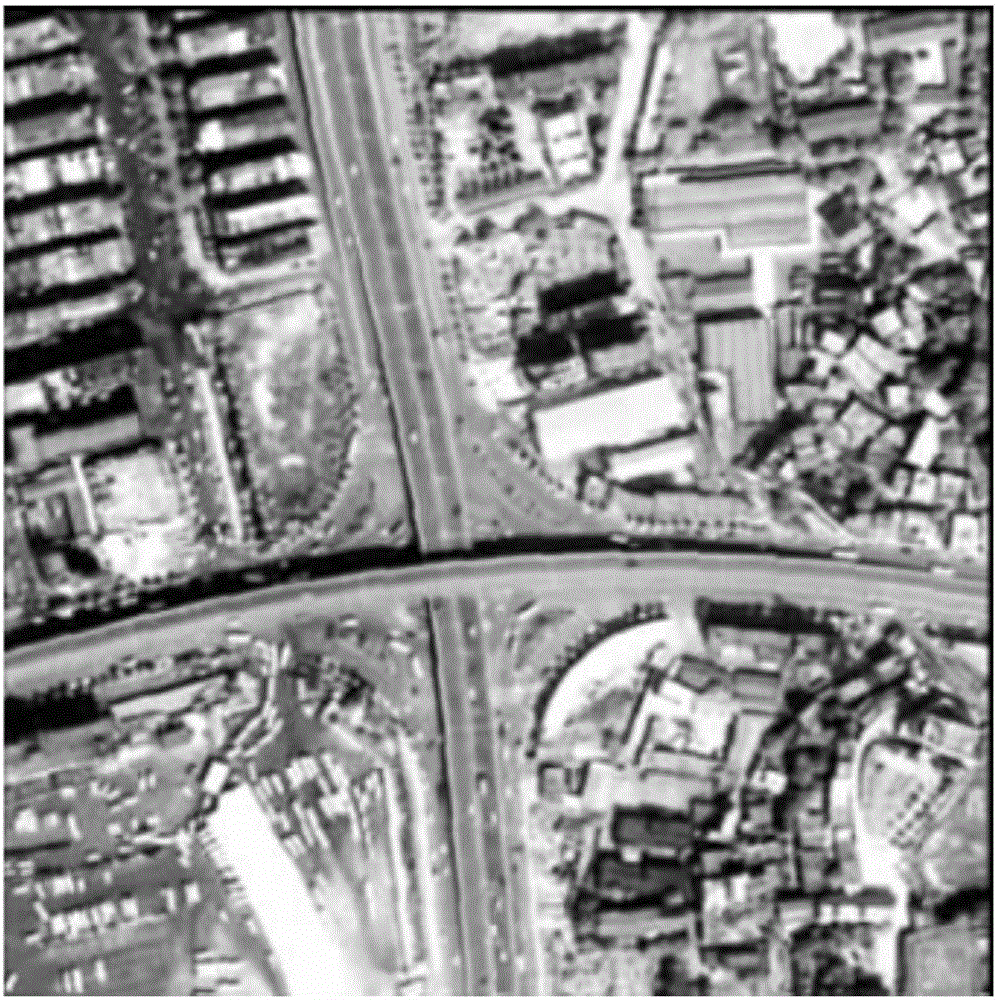
[0046] refer to figure 1 , the present invention provides a method for extracting road information from high-resolution remote sensing images, comprising the following steps:

[0047] Step S1, image preprocessing: use enhancement and filtering methods to achieve the purpose of enhancing the difference between the road image and the background image; in the process of image processing, convert the RGB color space image into an HSV color space image to improve the accuracy of subsequent image segmentation quality;

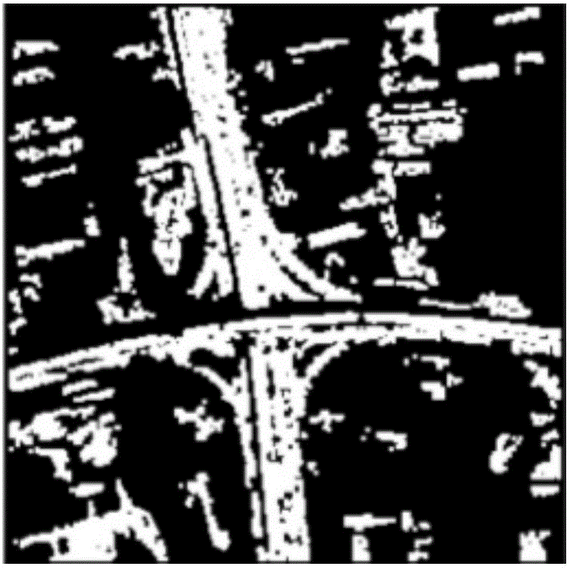
[0048] Step S2, road image segmentation method:

[0049] In the extraction of remote sensing image information, the phenomena of "same object with different spectrum" and "same spectrum with different object" are often accompanied, which have a great impact on the accurate classification of remote sensing images. How to accurately segment roads and keep road information as much as possible , instead of removing the road information as much as possible, which is ver...


PUM


Abstract

The present invention discloses a high-resolution remote sensing image road information extraction method. The method comprises the following steps: image preprocessing: employing an enhanced and filtering method to realize the purpose of the difference of a road image and a background image; a road image segment method: improving the traditional area growth algorithm and adding a secondary cluster method after growth to remove the complex small plates distributed in the image as much as possible so as to allow the ground object connected with the road to be separated from each other as far as possible; image analysis and identification: and employing a mathematical morphology method and structural elements with a certain shape to measure and extract the corresponding shaped in the image to reach the purpose of the analysis and identification of the image, convert the RGB image to an HSV image in the image processing process and improve the area growth algorithm to adapt for the extraction road so as to greatly improve the quality of the road segment, have high precision of the extraction of the city road, and especially adapt for the extraction of the city main road.

Description

technical field [0001] The invention relates to the technical field of road information extraction, in particular to a method for extracting road information from high-resolution remote sensing images. Background technique [0002] Compared with low- and medium-resolution remote sensing images, the features of high-resolution images are clearer and the details are more obvious. How to quickly obtain these information to update the geographic information database has become an urgent problem to be solved in the application of high-resolution remote sensing technology. How to extract road information scientifically and effectively is a hot and difficult point at present, and needs further research. [0003] In recent years, with the successive launches of high-resolution remote sensing satellites such as IKONOS, QuickBird, and SPOT-5, the processing and application of high-resolution remote sensing satellite data has gradually become a research hotspot in the field of remote ...

Claims


Application Information

Patent Timeline
Patent Type & Authority Applications(China)
IPC IPC(8): G06K9/00G06K9/34G06K9/46G06K9/62
CPCG06V20/182G06V10/267G06V10/44G06F18/23
Inventor 李丽韦金丽
Owner INST OF REMOTE SENSING & DIGITAL EARTH CHINESE ACADEMY OF SCI
Why Eureka
Try Eureka