
Synchronous location and mapping method

A synchronous positioning and map technology, applied in 3D modeling, image enhancement, image analysis and other directions, can solve the problems of slow attitude map optimization, difficulty in building accurate scale maps, and inability to use navigation, etc., to improve the optimization speed and/or or the effect of efficiency

Active Publication Date: 2017-01-04
NINGBO ONSIGHT CO LTD
View PDF3 Cites 31 Cited by
  • Summary
  • Abstract
  • Description
  • Claims
  • Application Information

AI Technical Summary

Problems solved by technology

First of all, the monocular SLAM scheme is difficult to estimate the scale of the real world, and it is often difficult to construct a map of an accurate scale; secondly, the SLAM scheme generally generates a three-dimensional point cloud map, which is composed of scattered points in space and does not have continuity in space. It is used for navigation; in addition, the SLAM based on the graph optimization scheme will add each frame of image to the pose map for optimization, which will cause the pose map to be too large and the optimization speed will be slow

Method used


Image

  • Synchronous location and mapping method
  • Synchronous location and mapping method
  • Synchronous location and mapping method

Examples


Embodiment Construction

[0024] The inventive concepts of the present disclosure are described below using terms commonly used by those skilled in the art to convey the substance of their work to others skilled in the art. These inventive concepts may, however, be embodied in many different forms and should not be construed as limited to the embodiments set forth herein. Rather, these embodiments are provided so that this disclosure will be thorough and complete, and will fully convey the scope of inclusion to those skilled in the art. It should also be noted that these embodiments are not mutually exclusive. Components, steps or elements from one embodiment may be assumed to be present or used in another embodiment. Various alternative and / or equivalent implementations may be substituted for the specific embodiments shown and described without departing from the scope of the embodiments of the present disclosure. This application is intended to cover any adaptations or variations of the embodiments...


PUM


Abstract

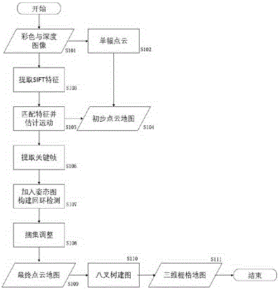
The embodiments of the invention relate to a synchronous location and mapping method. The method comprises the following steps: based on magnitude of interframe motion, selecting a key frame sequence from image frames, based on an interframe matching result of the key frame sequence, introducing the image frames into an attitude graph, and based on the attitude graph, constructing one or more effective detection loops for performing bundle adjustment and correcting the image frames based on the attitude graph after the bundle adjustment. The method can effectively reduce the scale of optimization calculation.

Description

technical field [0001] The disclosure belongs to the field of machine vision, and in particular relates to a method for synchronous positioning and mapping. Background technique [0002] At this stage, the movement of robots and / or autonomous vehicles mostly relies on manual path planning, and the autonomous navigation capabilities of robots and / or autonomous vehicles rely on simultaneous localization and mapping technology (Simultaneous Localization and Mapping, hereinafter referred to as SLAM). It aims to solve the problem of using sensor information to efficiently and accurately construct (Mapping) the surrounding environment when a robot and / or self-driving vehicle enters an unknown working environment, and at the same time obtain the position and attitude of the device in space (Localization) . In addition to being applied in the field of robotics, SLAM technology can also be used in space tracking and automatic driving of virtual reality and augmented reality devices....

Claims


Application Information

Patent Timeline
IPC IPC(8): G06T17/00G06T17/05G06T7/00
CPCG06T17/005G06T17/05G06T2200/32G06T2207/10016G06T2207/10024G06T2207/10028
Inventor 朱少岚
Owner NINGBO ONSIGHT CO LTD
Learn More