Eureka AIR delivers breakthrough ideas for toughest innovation challenges, trusted by R&D personnel around the world.

Correction method of water level storage-capacity curve by adopting reservoir section method

A storage capacity curve and storage water level technology, applied in special data processing applications, instruments, electrical digital data processing, etc., can solve problems such as complex methods, inconsistent measurement time of topographic data and section data, and difficult collection of topographic data

Active Publication Date: 2017-02-01
CHANGJIANG RIVER SCI RES INST CHANGJIANG WATER RESOURCES COMMISSION
View PDF1 Cites 7 Cited by
  • Summary
  • Abstract
  • Description
  • Claims
  • Application Information

AI Technical Summary

Problems solved by technology

[0004] The technical problem mainly solved by the present invention is to provide a method for correcting the water level storage capacity curve of the reservoir cross-section method, which can solve the problem that the implementation method of the prior art is relatively complicated, the required topographical data is difficult to collect, and the measurement time of the topographical data and the cross-section data is inconsistent. The problem with this approach is often difficult to implement

Method used


Image

  • Correction method of water level storage-capacity curve by adopting reservoir section method
  • Correction method of water level storage-capacity curve by adopting reservoir section method
  • Correction method of water level storage-capacity curve by adopting reservoir section method

Examples


Embodiment 1

[0063] The concrete steps of embodiment one are as follows:

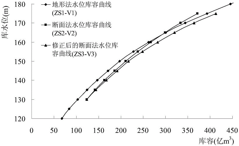
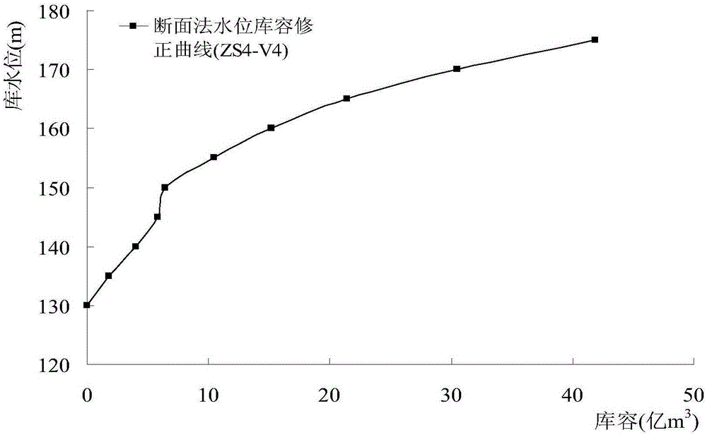
[0064] Collect data on the cross-section of the main and tributary streams of the Three Gorges Reservoir and the water level storage capacity curve ZS1-V1 of the reservoir topographic method. , Quxi River, Long River, and Xiaojiang tributaries Xiaojiang also includes Nanhe, Donghe, Puri, Penghe and other tributaries, Meixi River, Daning River, Yandu River, Qinggang River, Xiangxi River, a total of 14 tributaries, See Table 1, figure 2 and Figure 4 ;

[0065] Table 1 Water level storage capacity curve ZS1-V1 of the Three Gorges Reservoir topographic method

[0066]

[0067] Establish a one-dimensional hydrodynamic model of the main and tributary channels of the Three Gorges Reservoir, and use this model to calculate the water level and storage capacity curve ZS2-V2 of the main and tributary channels of the Three Gorges Reservoir, see Table 2 and figure 2 ;

[0068] Table 2 Water level storage capacity curv...


PUM


Abstract

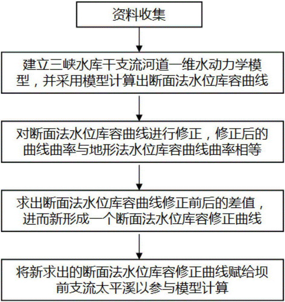
The invention relates to a correction method of a water level storage-capacity curve by adopting a reservoir section method. The correction method comprises the steps of collecting data of a water level storage-capacity curve ZS1-V1 by adopting reservoir main stream and branch river section and reservoir terrain methods; establishing a reservoir one-dimensional hydrodynamic model, and calculating a water level storage-capacity curve ZS2-V2 with the section method by adopting the model; correcting the water level storage-capacity curve by adopting the section method, so that the curvature of the corrected water level storage-capacity curve ZS3-V3 by adopting the section method is equal to that of a water level storage-capacity curve by adopting the terrain method; calculating a difference value between the water level storage-capacity curve ZS3-V3 and the water level storage-capacity curve ZS2-V2, so that a new water level storage-capacity correction curve ZS4-V4 by adopting the section method is formed; assigning the new water level storage-capacity correction curve ZS4-V4 by adopting the section method to a hypothetical branch, and adding the branch to the model in the front stage of a dam for calculation. The problem of inconformity of the section method and the terrain method can be solved, the reservoir regulation calculation accuracy is high, and technical support can be provided for reservoir regulation.

Description

technical field [0001] The invention relates to the technical field of water conservancy engineering, in particular to a method for correcting a water level storage capacity curve of a reservoir section method. Background technique [0002] There are two methods for calculating reservoir storage capacity: the topographic method and the cross-section method. The principle of calculating the reservoir water level and storage capacity curve by the cross-section method is simple, but the accuracy is lower than that calculated by the topographic method. Reservoir design is based on the storage capacity curve of the topographic method. When the one-dimensional hydrodynamic model of the reservoir is used to calculate the flood evolution and regulation and storage, the measured large section is used to reflect the river topography. It is assumed that the adjacent sections are prismatic, and the actual river bank changes along the way are extremely complicated. At the same time There...

Claims


Application Information

Patent Timeline
IPC IPC(8): G06F17/50
CPCG06F30/13G06F30/367
Inventor 黄仁勇
Owner CHANGJIANG RIVER SCI RES INST CHANGJIANG WATER RESOURCES COMMISSION
Why Eureka
Eureka Blog
Learn More