Vehicle self-positioning method based on street view image database

An autonomous positioning and database technology, applied in electrical digital data processing, special data processing applications, photo interpretation and other directions, can solve the problems of consuming large hardware equipment, unable to be used for a long time, and not suitable for long-distance use of accumulated errors, etc. The effect of improving operating efficiency, low cost and strong practicability

Active Publication Date: 2017-02-15
CHANGAN UNIV
View PDF4 Cites 38 Cited by
  • Summary
  • Abstract
  • Description
  • Claims
  • Application Information

AI Technical Summary

Problems solved by technology

[0006] In order to solve the technical problems existing in the existing vehicle positioning technology that need to consume a large amount of hardware equipment, so it is...

Method used


Image

  • Vehicle self-positioning method based on street view image database
  • Vehicle self-positioning method based on street view image database
  • Vehicle self-positioning method based on street view image database

Examples


Embodiment

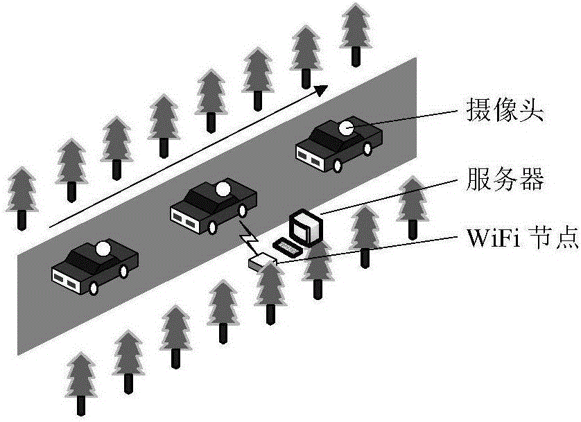
[0096] The experimental environment is: this test uses BYD Surui C4 to collect data at a speed of 3km / h on a straight road (due to occlusion, GPS signal is poor), and the Blaser-acA1600 camera is installed on the roof, such as Figure 6 shown. The image sequence is recorded synchronously through an external trigger signal, with a speed of 30frame / s and a resolution of 1600×1200pixels. The operating platform is Windows XP system, 2.85GHz CPU and MATLAB R2009a.

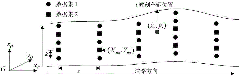
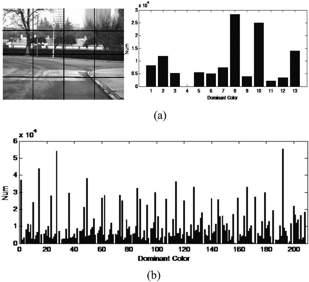
[0097] When constructing a database, we set k=1.5m and s=3m. In a certain section, 625 shooting nodes are selected. At each collection point, the vehicle vertically shoots the front scene to form a data set, some images such as Figure 7 As shown in Fig. 1, the images taken with 286 collection points are selected and stored in Dataset 2. Main color feature information and SURF feature points have been pre-stored in the database. An image taken at a certain moment, its main color features are as follows: Figur...


PUM


Abstract

The invention discloses a vehicle self-positioning method based on a street view image database. The vehicle self-positioning method comprises the following steps of 1, collecting view images by a camera, and extracting main color feature vector information, SURF feature points and position information of the collected images, and storing the extracted information in the database; 2, taking the shot images in a vehicle driving process as to-be-matched images, extracting main color feature vectors of the to-be-matched images, obtaining an initial matched image by calculating the similarity of the main color feature vector of the to-be-matched images and the main color feature vector of the images in the original database, extracting the position information of the initial matched image, and preliminarily determining the position of the vehicle; and 3, extracting adjacent-region images of the initial matched image, forming a searching space, performing feature point matching on the to-be-matched images and the images in the searching space to obtain an optimal matched image, extracting the shooting position coordinate of the optimal matched image and position coordinates of other eight adjacent regions, calculating the weight of each coordinate, and then calculating the accurate coordinate of the vehicle position through a formula.

Description

technical field [0001] The invention belongs to the technical field of vehicle positioning, and in particular relates to a vehicle autonomous positioning method based on a street view image database in a GPS blind spot. Background technique [0002] Vehicle high-precision positioning is an important part of Intelligent Transportation System (ITS), and a key technology for safe autonomous navigation. Current vehicle navigation systems usually use civilian GPS to estimate vehicle position, however such GPS has an error of 5 to 30 meters due to building reflections and occlusion of GPS signals. On the other hand, RTK-GPS can estimate the vehicle position more accurately, but it is easy to be blocked and the cost is high. In order to overcome these problems, some research groups have proposed to use sensors such as sonar, laser scanners, and cameras to study the corresponding algorithms when GPS cannot correctly perform vehicle autonomous positioning, mainly including the follo...

Claims


Application Information

Patent Timeline
IPC IPC(8): G06F17/30G06K9/00G06K9/46G06K9/62G01C11/08G01C21/26
CPCG06F16/583G01C11/08G01C21/26G06V20/56G06V10/462G06F18/22
Inventor 赵祥模周经美徐志刚程鑫张立成王润民闵海根李骁驰王振孙朋朋
Owner CHANGAN UNIV
Why Eureka
Try Eureka