A Method of Extracting Spatial Distribution of Watershed Free Water Storage Capacity by Topographic Index

A technology of terrain index and water storage capacity, which is applied in electrical digital data processing, special data processing applications, instruments, etc. It can solve the problem of not considering the spatial variability of free water capacity, unfavorable development of distributed hydrological models, and inability to extract spatial distribution, etc. problems, to achieve the effect of stable and reliable data sources, conducive to direct invocation, and promotion of in-depth development

Active Publication Date: 2019-07-12
HOHAI UNIV
View PDF3 Cites 0 Cited by
  • Summary
  • Abstract
  • Description
  • Claims
  • Application Information

AI Technical Summary

Problems solved by technology

However, most of the current determination methods are subjective and empirical, and cannot objectively determine the parameters through the physical characteristics of the watershed from the perspective of the physical meaning of the parameters.
In addition, the current methods basically determine the parameters in a lumped manner, that is, assuming that the parameters are uniform in space, without considering the spatial variability of free water capacity, and cannot extract a reasonable spatial distribution, which limits the use of this parameter in The application of distributed modeling is not conducive to the development of domestic distributed hydrological models

Method used


Image

  • A Method of Extracting Spatial Distribution of Watershed Free Water Storage Capacity by Topographic Index
  • A Method of Extracting Spatial Distribution of Watershed Free Water Storage Capacity by Topographic Index
  • A Method of Extracting Spatial Distribution of Watershed Free Water Storage Capacity by Topographic Index

Examples


Embodiment Construction

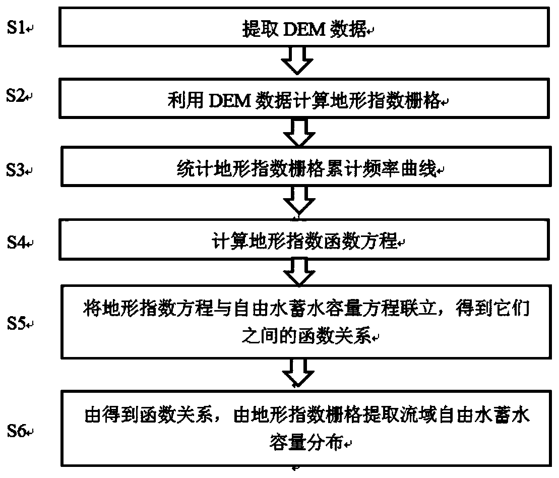
[0055] Such as Figure 1 to Figure 8 As shown, a method for extracting the spatial distribution of watershed free water storage capacity by using terrain index in the present invention comprises the following steps:

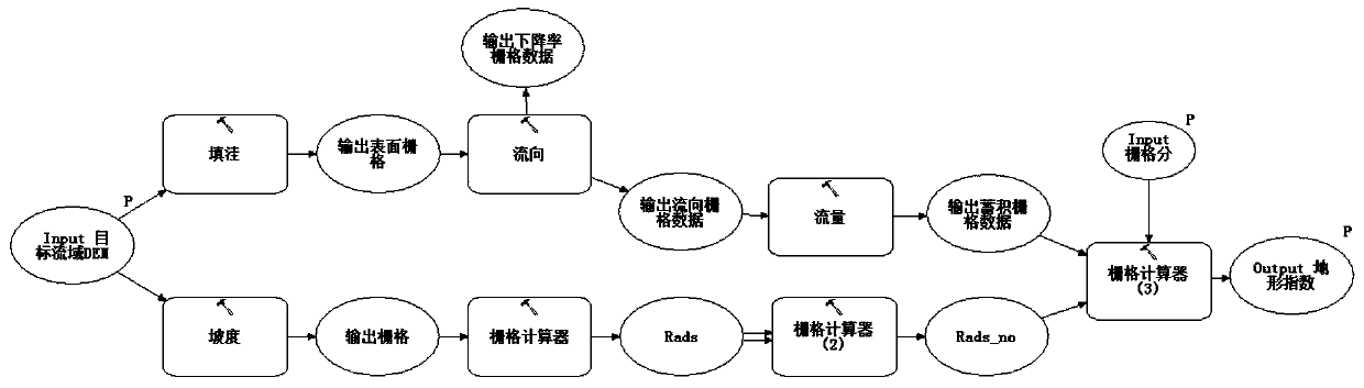
[0056] S1. Use the topographic information system software ArcGIS to build a geoprocessing workflow to extract the DEM raster data of the target watershed, such as figure 2 , which includes:

[0057] 1) Filling;

[0058] 2) Calculate the flow direction;

[0059] 3) Set the flow threshold and calculate the confluence flow;

[0060]4) Determine the outlet site of the watershed;

[0061] 5) Extract the target watershed.

[0062] S2. Using the extracted DEM grid data to calculate the terrain index grid, the terrain index calculation steps include:

[0063] 1) From the DEM data of the watershed, after filling, calculate the flow direction, and calculate the confluence to obtain the accumulative discharge grid (Acc).

[0064] 2) Calculate the slope raster (grad...


PUM


Abstract

The invention discloses a method for extracting drainage basin free water storage capacity space distribution by utilizing terrain indexes. The method comprises the main following steps that drainage basin digital elevation model (DEM) data is extracted; drainage basin terrain index grids are calculated by utilizing drainage basin DEM data; statistics is conducted on cumulative frequency curves of the drainage basin terrain index grids; equations of the terrain index cumulative frequency curves are calculated; the equations of the terrain index cumulative frequency curves and equations of drainage basin free water frequency curves are synthesized to solve the corresponding function relationship about the terrain indexes and free water storage capacity; the free water storage capacity of each terrain index grid unit is solved based on the function relationship so as to obtain drainage basin free water storage capacity space distribution. The method has the advantages of being stable and reliable in data source, high in computational efficiency, objective and reasonable in result and the like and facilitates direct invoking of distributed hydrologic models.

Description

technical field [0001] The invention belongs to the technical field of hydrology, and specifically refers to a method for extracting the spatial distribution of watershed free water storage capacity through topographic index. Background technique [0002] With the development of technologies such as remote sensing, geographic information, and digital watersheds, the distributed hydrological model based on the grid digital elevation model (DEM, Digital Elevation Model) has become an important model for its full consideration of the spatial variation of rainfall and underlying surface conditions. Trends in watershed hydrological modeling. When modeling a distributed hydrological model, the main difficulty lies in how to obtain the spatial distribution of model parameters. In order to further promote the development of watershed hydrological models, more in-depth research is needed on the extraction methods of the spatial distribution of parameters. [0003] Free water storag...

Claims


Application Information

Patent Timeline
Patent Type & Authority Patents(China)
IPC IPC(8): G06F17/50
CPCG06F30/20
Inventor 姚成童冰星黄小祥李致家
Owner HOHAI UNIV
Why Eureka
Try Eureka