A Feature Extraction and Reconstruction Method for Complex Geological Surfaces

A technology for feature extraction and complex geology, applied in instrumentation, computing, image data processing, etc., can solve problems such as fragmentation of feature points or feature lines, low efficiency, and large amount of calculation

Active Publication Date: 2020-10-27
UNIV OF ELECTRONICS SCI & TECH OF CHINA
View PDF5 Cites 0 Cited by
  • Summary
  • Abstract
  • Description
  • Claims
  • Application Information

AI Technical Summary

Problems solved by technology

[0030] The purpose of the present invention is to solve the problem that the terrain feature extraction algorithm based on triangulation network DEM in the prior art has a large amount of calculation and low efficiency, the extraction of feature points or feature lines is prone to fragmentation, and the terrain reconstruction method has non-smoothness , a complex geological surface feature extraction and reconstruction method is proposed

Method used


Image

  • A Feature Extraction and Reconstruction Method for Complex Geological Surfaces
  • A Feature Extraction and Reconstruction Method for Complex Geological Surfaces
  • A Feature Extraction and Reconstruction Method for Complex Geological Surfaces

Examples


Embodiment Construction

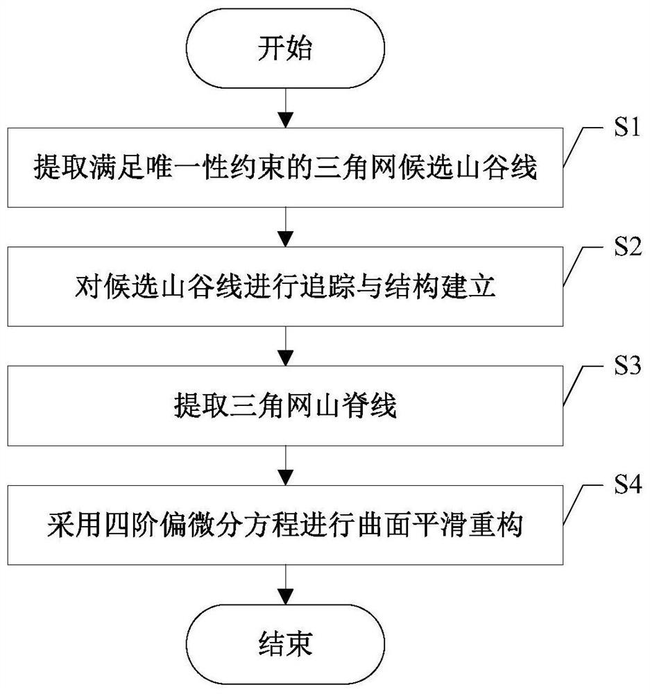
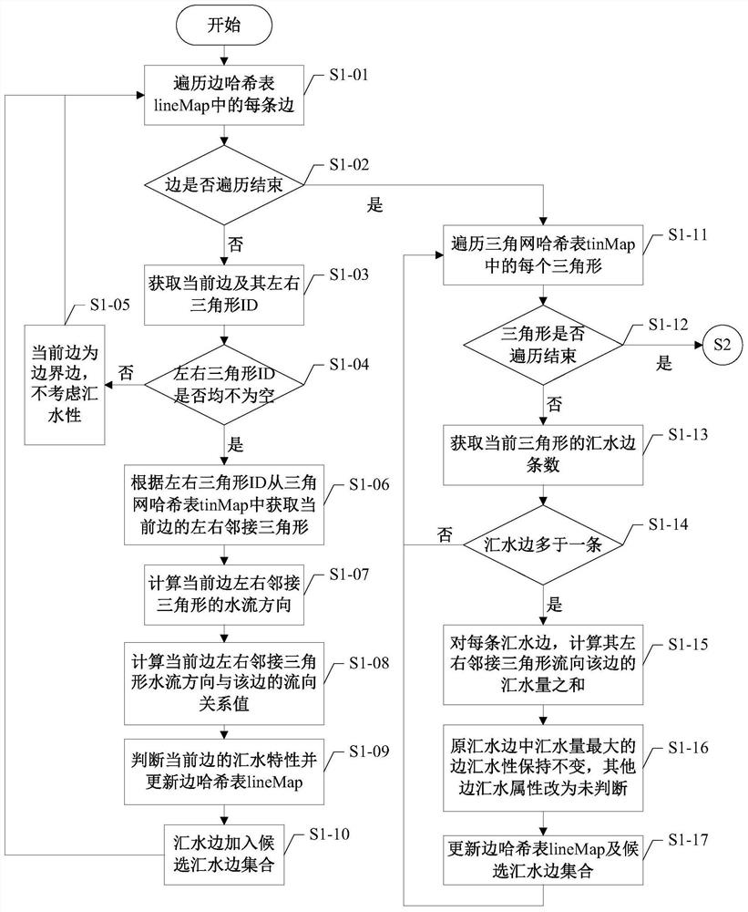
[0092] Embodiments of the present invention will be further described below in conjunction with the accompanying drawings.

[0093] The main data structure used in the embodiment of the present invention is as shown in table 1:

[0094] Table 1

[0095]

[0096] In Table 1, the point ID of the point data structure is a string type, which is self-increasing by 1; the triangle ID in the regular linked list structure of the triangular network is an integer, and is self-increasing by 1, and the three-point ID of the triangle is the ID of the corresponding point structure ;The edge ID in the edge structure of the triangulation network is a string type, which is spliced ​​by the point IDs corresponding to the two ends of the edge. Among them, the point ID with a larger elevation value is in front, and the point ID with a smaller elevation value is behind. The ID of the end point is the ID of the corresponding point structure, the attribute value of the adjacent triangle on the l...


PUM


Abstract

The invention discloses a method for feature extraction and reconstruction of complex geological curved surfaces. By referring to the relevant knowledge of river network tracking in hydrological analysis and introducing surface tracking, the problem of fragmentation in feature line extraction is solved. It greatly reduces the calculation amount of the terrain feature extraction part, and greatly improves the extraction efficiency. In addition, the present invention aims at the shortcomings of the existing terrain reconstruction method, such as large amount of calculation, undetermined terrain skeleton points, etc., adopts the idea of ​​smooth reconstruction of terrain surface based on the fourth-order partial differential equation, in order to preserve the original surface during the smoothing process The feature point constraints are introduced to achieve a better balance between surface smoothing and surface feature preservation.

Description

technical field [0001] The invention belongs to the technical field of terrain feature extraction and reconstruction, and in particular relates to the design of a complex geological surface feature extraction and reconstruction method. Background technique [0002] The concept of Digital Elevation Model (DEM, Digital Elevation Model) was proposed by Professor Miller of the Massachusetts Institute of Technology in 1958. The real terrain is analyzed and digitized. Based on the powerful processing capabilities of current computers, compared with traditional paper terrain models (such as maps) and images, digital terrain based on digital elevation models has at least the following advantages: [0003] (1) Facilitate the storage and management of terrain data; [0004] (2) It is convenient to analyze and calculate the terrain; [0005] (3) It can be scaled without loss, which is convenient for analyzing terrain details; [0006] (4) It is convenient to design algorithms to in...

Claims


Application Information

Patent Timeline
Patent Type & Authority Patents(China)
IPC IPC(8): G06K9/46G06T17/30
CPCG06T17/30G06T2215/06G06V10/44
Inventor 姚兴苗王运璇胡光岷
Owner UNIV OF ELECTRONICS SCI & TECH OF CHINA
Why Eureka
Try Eureka