User positioning system and positioning method based on urban community public wifi hotspot set

A community public and positioning system technology, applied in the field of positioning systems, can solve problems such as the inability to locate the floor where the user is located, the inability of the user to know the specific location, and the inability to give the user's three-dimensional coordinates, etc., to achieve an easy-to-understand, fine-positioning, and strong applicability Effect

Inactive Publication Date: 2017-03-08
WUHAN NEIGHBOURHOOD CLOUD TECH CO LTD
View PDF9 Cites 2 Cited by
  • Summary
  • Abstract
  • Description
  • Claims
  • Application Information

AI Technical Summary

Problems solved by technology

At present, there are many software manufacturers that provide maps and positioning services on widely used smartphones, such as Baidu Maps, AutoNavi Maps, etc. Three-dimensional coordinates, suc

Method used


Image

  • User positioning system and positioning method based on urban community public wifi hotspot set
  • User positioning system and positioning method based on urban community public wifi hotspot set

Examples


Embodiment 1

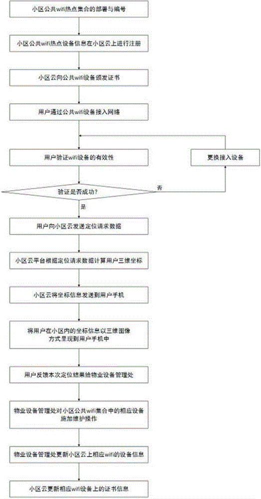
[0045] Embodiment 1 Positioning steps of the present invention:

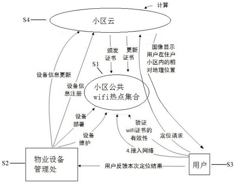
[0046] 1) The property equipment management office of a residential community deploys a collection of public wifi hotspots in the community, including 100 routers, numbered as 1-100;

[0047] 2) The property equipment management office registers the device information of 100 routers in the public wifi hotspot collection of the community on the cloud platform of the community;

[0048] 3) The community cloud platform saves the router device information in the community's public wifi hotspot set according to the number, and generates a certificate for each router, which contains the historical change records of the device information;

[0049] 4) Residents or visitors who enter the residential area access the network through the router numbered N in the community's public wifi hotspot set, where N is a positive integer, 1≤N≤100;

[0050] 5) Residents or visitors verify the validity of the certificate on Router N,...

Embodiment 2

[0059] In the present invention, when the user finds that the certificate verification of the connected wifi device fails, he will timely feed back the situation to the property management office. The property equipment management office can timely grasp the operation status of the public wifi hotspots in the community according to the user feedback results.

[0060] The steps are as follows:

[0061] 1) The property equipment management office of a commercial community (a large shopping plaza or an office building, etc.) deploys a collection of public wifi hotspots in the community, including 150 routers, numbered 1-150;

[0062] 2) The property equipment management office registers the device information of 150 routers in the public wifi hotspot collection of the community on the cloud platform of the community;

[0063] 3) The community cloud platform saves the router device information in the community's public wifi hotspot set according to the number, and generates a cer...


PUM


Abstract

The invention discloses a user positioning system and positioning method based on a urban community public wifi hotspot set. The system comprises the community public wifi hotspot set, a property equipment management office, a user and a cloud entity, wherein the user access the network through the community public wifi to verify the validity of a certificate of the accessed wifi equipment, and the sends a positioning request to the community cloud; the community cloud computes a three-dimensional coordinate of the user in the residency community according to the wifi signal information carried in the request data and displays the three-dimensional coordinate on a user mobile phone in a three-dimensional image. The community cloud platform is used for issuing the certificate to the community wifi equipment, the validity of the wifi equipment certificate is verified when the user accesses the community wireless network, thereby guaranteeing the reality of the community public wifi hotspot set; the three-dimensional coordinate in the urban community is displayed for the user in the three-dimensional image mode, when the user is in high-rise building, the specific floor of the user can be displayed; the positioning is precise and easy to understand; the operation is simple and convenient, and the applicability is strong.

Description

technical field [0001] The invention relates to the field of positioning systems, in particular to a user positioning system and a positioning method based on public wifi hotspot collections in urban communities. Background technique [0002] Urban districts mainly include residential districts, commercial districts, office districts and schools, which are important areas for urban residents to live, work and study. Taking modern urban residential quarters as an example, most of the building layouts are determinant or peripheral, and the buildings have the characteristics of high density, high floors, and similar appearance. For residents or visitors who are not familiar with the layout of the community, it is very easy to find the way. The problem of getting lost. At present, there are many software manufacturers that provide maps and positioning services on smartphones that are widely used, such as Baidu Maps, AutoNavi Maps, etc. Three-dimensional coordinates, such as fo...

Claims


Application Information

Patent Timeline
IPC IPC(8): H04W16/20H04W64/00H04L29/06H04L29/08
CPCH04W16/20H04L65/1073H04L67/10H04W64/003
Inventor 向騻何家军黄浩东王承云汪流浪
Owner WUHAN NEIGHBOURHOOD CLOUD TECH CO LTD
Why Eureka
Try Eureka