Method for building standardized remote sensing satellite data integration general metadata model

A metadata model and remote sensing satellite technology, applied in the field of remote sensing satellite data integration and application, can solve the problems of unusable satellite data, affect the open utilization of remote sensing satellite data, and cannot fully meet the needs of satellite data integration system development, etc., to achieve The effect of ensuring compatibility and interoperability

Inactive Publication Date: 2017-03-15
WUHAN UNIV +1
View PDF5 Cites 14 Cited by
  • Summary
  • Abstract
  • Description
  • Claims
  • Application Information

AI Technical Summary

Problems solved by technology

However, these standards are independent and not integrated, so they cannot fully meet the needs of satellite data integration system development
[0007] To sum up, in the existing metadata integration methods, there is still a lack of a unified satellite metadata model to integrate and describe multi-source heterogeneous remote sensing satellite data such as satellite images, ground observations and model simulations.
At the same time, serious deficiencies in the integration and standardization of earth observation data have also directly affected the open use of remote sensing satellite data, and there are practical problems such as "not easy to use, not good at using" satellite data

Method used


Image

  • Method for building standardized remote sensing satellite data integration general metadata model
  • Method for building standardized remote sensing satellite data integration general metadata model
  • Method for building standardized remote sensing satellite data integration general metadata model

Examples


Embodiment Construction

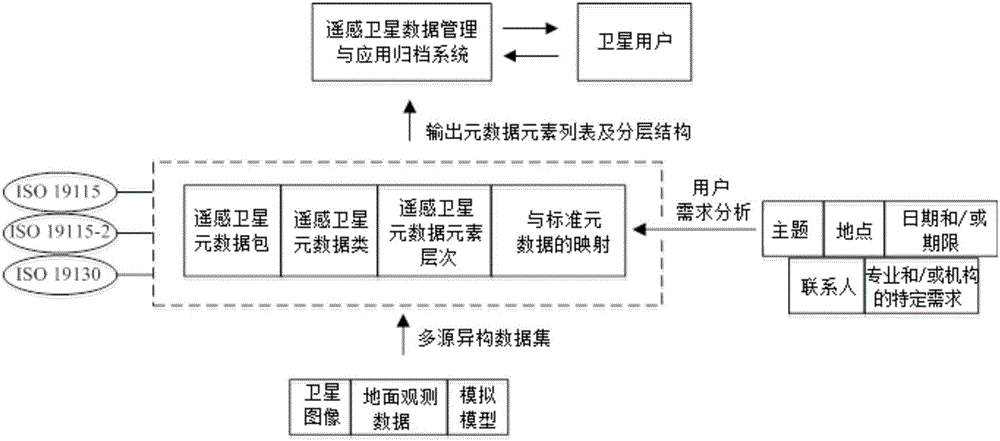
[0044] On the basis of the ISO / TC 211 international satellite standard, integrate and expand ISO 19115 and ISO 19115-2, and combine the geographic positioning information and sensor characteristics in ISO 19130, while considering the special needs of professional applications and different organizations, Construct a general metadata model for remote sensing satellite data integration, such as figure 1 shown. Describe the basic structure and content of satellite data by defining metadata public sets, metadata core elements and their internal associations, and metadata extensions, and map heterogeneous data from different sources into a standardized data type .

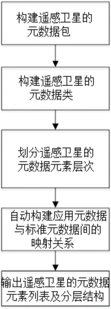
[0045] See figure 2 , the concrete steps of the inventive method are as follows.

[0046] Step 1: Construct the metadata package of the remote sensing satellite, which includes the main metadata package, supporting metadata package, extended metadata package and special metadata package.

[0047] This step further ...


PUM


Abstract

The invention discloses a method for building a standardized remote sensing satellite data integration general metadata model. The method includes the steps that S1, standard metadata are set up, and standard metadata setup includes setting up a metadata package of a remote sensing satellite, setting up metadata the class of the remote sensing satellite and dividing metadata element level of the remote sensing satellite; S2, a Bayes method is used for automatically setting up the mapping relation between application metadata and standard metadata, and the class of the application metadata elements is divided according to the mapping relation; S3, a metadata element list and the hierarchic structure thereof are output in the format of label output, and a metadata element dictionary of the remote sensing satellite is set up. Standardized management and application of the satellite metadata can be achieved, and the problem that for lack of a standardized general remote sensing satellite data model, global satellite remote sensing data information resource normalized sharing and application cannot be provided is solved.

Description

technical field [0001] The invention belongs to the technical field of remote sensing satellite data integration and application, and in particular relates to a method for establishing a general metadata model for standardized remote sensing satellite data integration. Background technique [0002] Countries around the world have successively launched various remote sensing satellites, and the era of global high-resolution observation has arrived. The scope of satellite remote sensing earth observation is getting wider and wider, covering water and energy cycle, land, ocean and other aspects. Satellite remote sensing information has become an indispensable strategic and economic resource, and its application industry contains huge opportunities for leapfrog development. Therefore, how to provide an efficient way of remote sensing satellite data management and information integration, and support the logical association expression, information semantic integration, and colla...

Claims


Application Information

Patent Timeline
Patent Type & Authority Applications(China)
IPC IPC(8): G06F17/30
CPCG06F16/24573
Inventor 谢榕李翔翔
Owner WUHAN UNIV
Why Eureka
Try Eureka