Power tower automatic positioning method and apparatus based on unmanned aerial vehicle laser point cloud

An automatic positioning and unmanned aerial vehicle technology, applied in the field of surveying and mapping laser point cloud data processing, can solve the problems of limited application scenarios and unstable accuracy, and achieve the effect of solving limited application scenarios

Active Publication Date: 2017-03-22
GUANGDONG ELECTRIC POWER SCI RES INST ENERGY TECH CO LTD
View PDF5 Cites 12 Cited by
  • Summary
  • Abstract
  • Description
  • Claims
  • Application Information

AI Technical Summary

Problems solved by technology

[0005] The embodiment of the present invention provides a method and device for automatic positioning of electrical towers based on UAV laser point clouds, which are used...

Method used


Image

  • Power tower automatic positioning method and apparatus based on unmanned aerial vehicle laser point cloud
  • Power tower automatic positioning method and apparatus based on unmanned aerial vehicle laser point cloud
  • Power tower automatic positioning method and apparatus based on unmanned aerial vehicle laser point cloud

Examples


Embodiment Construction

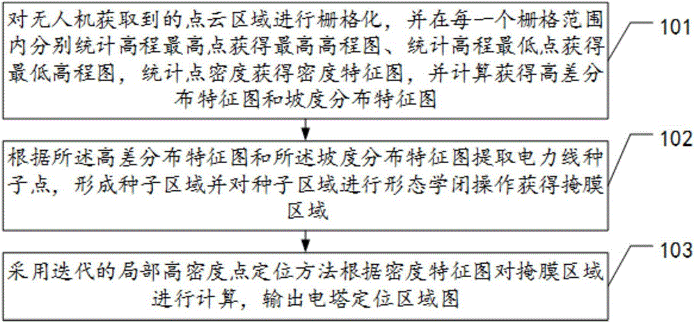
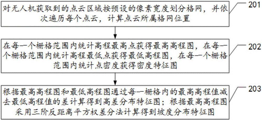
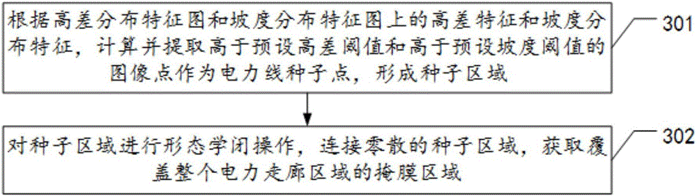
[0061] The embodiment of the present invention provides a method and device for automatic positioning of electrical towers based on UAV laser point clouds, which are used to solve the problems of limited application scenarios and unstable accuracy existing in existing airborne LiDAR point cloud positioning methods for electrical towers question.

[0062] In order to make the purpose, features and advantages of the present invention more obvious and understandable, the technical solutions in the embodiments of the present invention will be clearly and completely described below in conjunction with the accompanying drawings in the embodiments of the present invention. Obviously, the following The described embodiments are only some, not all, embodiments of the present invention. Based on the embodiments of the present invention, all other embodiments obtained by persons of ordinary skill in the art without making creative efforts belong to the protection scope of the present inv...


PUM


Abstract

The embodiments of the invention disclose a power tower automatic positioning method and apparatus based on an unmanned aerial vehicle laser point cloud, for solving the problems of limited application scenes and accuracy instability existing in a conventional power tower positioning method in an airborne LiDAR point cloud. The method provided by one embodiment comprises the following steps: performing grid processing on a point cloud area obtained by an unmanned aerial vehicle, respectively counting an elevation highest point in each grid scope to obtain a highest elevation graph and counting an elevation lowest point to obtain a lowest elevation graph, obtaining a density feature graph by counting point density, and obtaining a high-difference distribution feature graph and a gradient distribution feature graph through calculation; according to the high-difference distribution feature graph and the gradient distribution feature graph, extracting power line seed points, forming a seed area, and performing morphological closing operation on the seed area to obtain a mask area; and by use of a local high density point location method of iteration, according to the density feature graph, calculating the mask area, and outputting a power tower positioning area graph.

Description

technical field [0001] The invention relates to the field of laser point cloud data processing for surveying and mapping, in particular to an automatic positioning method and device for an electric tower based on a laser point cloud of an unmanned aerial vehicle. Background technique [0002] Electric towers are trapezoidal, triangular and other tower-shaped buildings. The height is usually 25-40 meters. It is a steel frame structure. Most of them are built near the power plants and distribution stations in the wild. It is an important facility in the power sector. It can protect and support overhead wires. The design, manufacture, installation, maintenance and quality inspection of power towers are important guarantees for the operation and development of modern power systems. Electric towers are installed in mountainous areas to form power corridors. Due to the remoteness of the place, it is necessary to use drones to detect them during maintenance, and the drones can o...

Claims


Application Information

Patent Timeline
IPC IPC(8): G01S17/88
CPCG01S17/88
Inventor 钱金菊王柯彭向阳易琳许志海张峰
Owner GUANGDONG ELECTRIC POWER SCI RES INST ENERGY TECH CO LTD
Why Eureka
Try Eureka