Ground point cloud segmentation method based on three-dimensional laser radar

A 3D laser and lidar technology, applied in 3D image processing, image data processing, instruments, etc., can solve the problems of missed detection of point cloud data, inability to process a large amount of disordered point cloud data, and poor real-time performance of a large amount of point cloud data , to achieve the effect of accurate extraction, high real-time performance and improved accuracy

Active Publication Date: 2017-03-22
CHANGAN UNIV
View PDF8 Cites 64 Cited by
  • Summary
  • Abstract
  • Description
  • Claims
  • Application Information

AI Technical Summary

Problems solved by technology

[0007] In order to solve the problems of missed detection of some point cloud data in the point cloud segmentation method of the prior art, inability to process a large amount of disordered point cloud data and poor real-time performance when processing a large amount of point cloud data, the present invention provides the following technical solutions to solve the problem:

Method used


Image

  • Ground point cloud segmentation method based on three-dimensional laser radar
  • Ground point cloud segmentation method based on three-dimensional laser radar
  • Ground point cloud segmentation method based on three-dimensional laser radar

Examples


Embodiment Construction

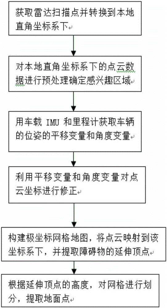
[0051] like figure 1 A kind of ground point cloud segmentation method based on three-dimensional laser radar provided by the present invention comprises the following steps:

[0052] Step 1: Establish a local Cartesian coordinate system with the center of the lidar as the coordinate origin, obtain the polar coordinate data of the 3D Lidar scanning point cloud around the vehicle and convert it to the local Cartesian coordinate system, and then analyze the point cloud in the local Cartesian coordinate system The data is preprocessed to determine the target area;

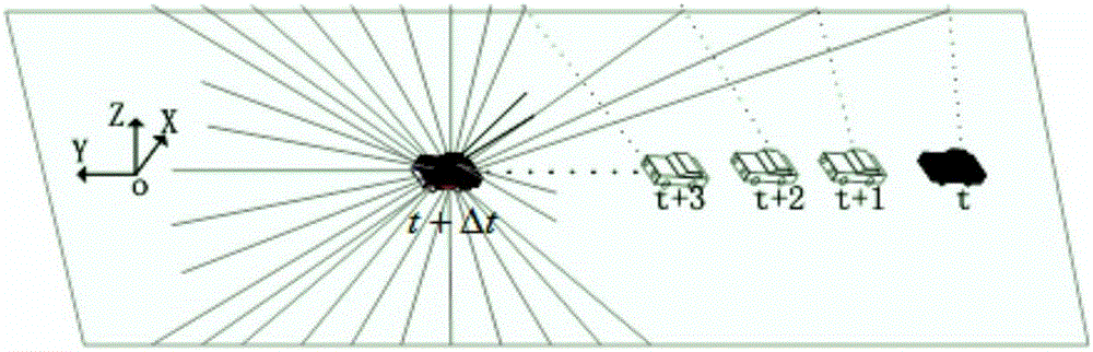
[0053] Step 2: In the local Cartesian coordinate system, use the on-board IMU and odometer to obtain the translation variable and angle variable of the vehicle's current pose relative to the previous moment position, and use the translation variable and rotation angle variable to compare the point cloud data in the local Cartesian coordinate system The coordinates are corrected;

[0054] Step 3, constructing a polar ...


PUM


Abstract

The invention discloses a ground point cloud segmentation method based on a three-dimensional laser radar. The ground point cloud segmentation method comprises the steps of: 1) acquiring polar coordinate data of three-dimensional laser radar scanning point cloud in the surrounding environment of a vehicle and converting the polar coordinate data to a local rectangular coordinate system; 2) correcting radar data by utilizing a vehicle-mounted IMU and an odometer; 3) constructing a polar coordinate grid map, and extracting an extension vertex in each grid according to vertical continuity of point cloud distribution in the grids; 4) extracting ground points in non-marginal grids according to height attributes of the extension vertexes and a ground smooth consistency criterion, and adopting a 3sigma criterion for further extraction of ground points in marginal grids. Compared with the prior art, the ground point cloud segmentation method can reduce ground extraction errors caused by motion of the vehicle, avoids the occurrence of over-segmentation and under-segmentation, is high in precision and high in reliability, has high real-time performance and can be widely used in the field of radar-based environment sensing technologies.

Description

technical field [0001] The invention relates to the field of unmanned driving technology, in particular to a ground point cloud segmentation method based on a three-dimensional laser radar. Background technique [0002] Three-dimensional lidar can obtain real-time and accurate environmental information around the vehicle and is rarely affected by illumination and weather changes, so it is widely used in the environmental perception system of unmanned vehicles. In the urban traffic environment, the most common obstacles are vehicles, pedestrians, trees, buildings, etc. To achieve accurate perception of these obstacles, these obstacles must first be accurately segmented from the radar data, and these obstacles They are all distributed on the ground and connected together by ground points, so the ground must be extracted first, otherwise the existence of ground points will make all the objects on the ground connected to each other, and the segmentation cannot be completed. The...

Claims


Application Information

Patent Timeline
Patent Type & Authority Applications(China)
IPC IPC(8): G06T15/00
CPCG06T15/005
Inventor 赵祥模孙朋朋徐志刚王润民闵海根李骁驰王振吴霞
Owner CHANGAN UNIV
Why Eureka
Try Eureka