System and method of unmanned aerial vehicle visual sense assistant position and flight control based on two-dimensional landmark identification

An auxiliary positioning and two-dimensional code technology, applied in the field of unmanned aerial vehicles, can solve the problems of low position accuracy and limited GPS accuracy, and achieve the effect of improving accuracy, positioning accuracy and stability

Active Publication Date: 2017-05-10
HUAZHONG UNIV OF SCI & TECH
View PDF3 Cites 36 Cited by
  • Summary
  • Abstract
  • Description
  • Claims
  • Application Information

AI Technical Summary

Problems solved by technology

In addition, a cascaded flight control system based on deviation-based adaptive compensation control is proposed to realize the smooth transition between the marker recognition state and the unrecognized state, improve the stability of flight control, and then improve the accuracy and rapidity of recognition. This solves the technical problem that the traditional integrated navigation technology in the prior art is limited by the accuracy of GPS, the position accuracy is low, and other equipment needs to be used to assist in improving the accuracy of reaching the target point during flight.

Method used


Image

  • System and method of unmanned aerial vehicle visual sense assistant position and flight control based on two-dimensional landmark identification
  • System and method of unmanned aerial vehicle visual sense assistant position and flight control based on two-dimensional landmark identification
  • System and method of unmanned aerial vehicle visual sense assistant position and flight control based on two-dimensional landmark identification

Examples


Embodiment Construction

[0042]In order to make the object, technical solution and advantages of the present invention clearer, the present invention will be further described in detail below in conjunction with the accompanying drawings and embodiments. It should be understood that the specific embodiments described here are only used to explain the present invention, not to limit the present invention. In addition, the technical features involved in the various embodiments of the present invention described below can be combined with each other as long as they do not constitute a conflict with each other.

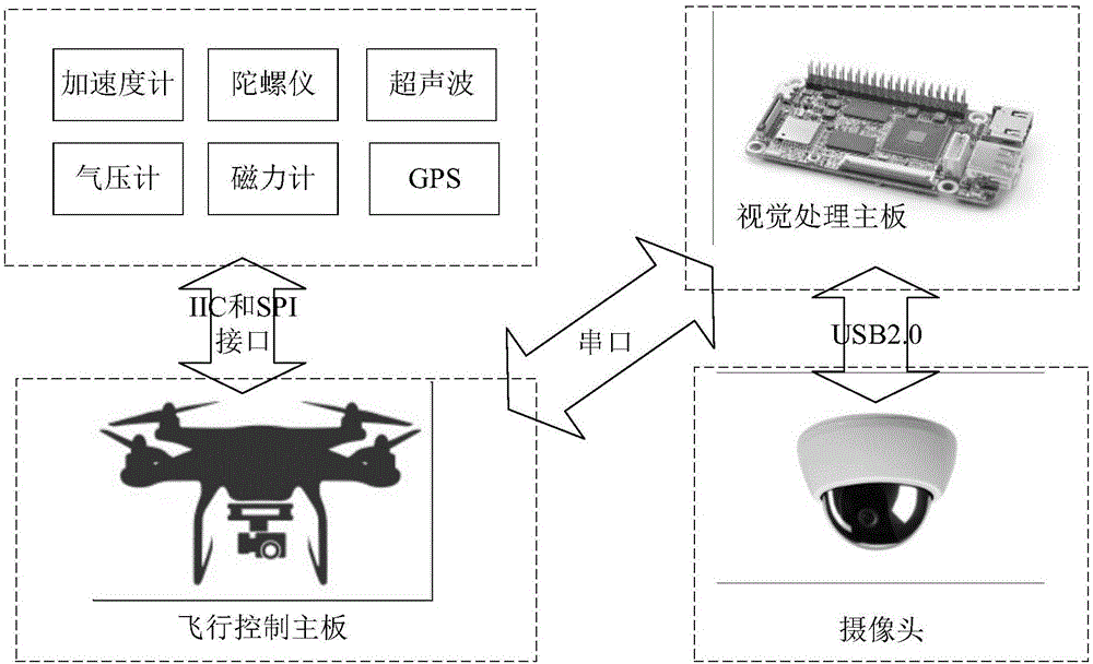
[0043] figure 1 Shown is a hardware structure diagram of a UAV high-precision autonomous flight disclosed in the embodiment of the present invention. figure 1 As shown in the hardware structure diagram, figure 1 The upper left part is a collection of navigation sensors, which can include accelerometers, gyroscopes, ultrasonic sensors, barometers, magnetometers, and GPS modules, etc., where each...


PUM


Abstract

The present invention discloses a system and method of unmanned aerial vehicle visual sense assistant position and flight control based on two-dimensional landmark identification. The system comprises an unmanned aerial vehicle body, a sensor module, a tracking locus generation module, a visual processing module, a sensor update module, a flight control module, a visual assist control switching module, an instruction output module and a camera. The two-dimensional marker arranged on the route specific position to perform visual extraction, an inertial navigation system is fused to perform calculation of accurate position and attitude information so as to assist and improve the precision of the GPS combination system, and diversification information guidance is provided for the unmanned aerial vehicle through two-dimensional encoding information to develop the diversity of a flight task. Besides, the present invention provides a cascade flight control system of adaptive compensation control based on deviation. The smooth transition of the marker identification state and the unidentification state is realized, the stability of the flight control is improved, and the accuracy of the identification is improved.

Description

technical field [0001] The invention belongs to the technical field of unmanned aerial vehicles, and more specifically relates to a visual aided positioning and flight control system and method for an unmanned aerial vehicle based on two-dimensional code identification. Background technique [0002] In recent years, with the development of intelligence science and control science, UAV has become a hot research topic. At present, drones are widely used in aerial photography, land surveying and mapping, geological rescue, fire rescue, traffic monitoring and other fields. UAVs not only have practical social application value, but also have important research significance in engineering and academia, such as agricultural plant protection, power inspection, forest fire prevention, disaster detection and other fields, and have broad development prospects. [0003] In the automatic flight of UAVs, the traditional integrated navigation technology is limited by the GPS accuracy prob...

Claims


Application Information

Patent Timeline
Patent Type & Authority Applications(China)
IPC IPC(8): G05D1/12
CPCG05D1/12
Inventor 刘磊谯睿智王永骥
Owner HUAZHONG UNIV OF SCI & TECH
Why Eureka
Try Eureka