Highway mileage stake number determining method based on electronic map and GPS coordinate

An electronic map and highway technology, applied in the computer field, can solve the problems of insufficient conversion accuracy, inability to determine the up and down directions of vehicles, etc., and achieve the effect of meeting the accuracy requirements.

Inactive Publication Date: 2017-05-31
THE THIRD AFFILIATED HOSPITAL OF THIRD MILITARY MEDICAL UNIV OF PLA
View PDF4 Cites 15 Cited by
  • Summary
  • Abstract
  • Description
  • Claims
  • Application Information

AI Technical Summary

Problems solved by technology

Although the existing technology performs the interchange of GPS coordinates and kilometer stakes, it cannot determine the up and down direction of the vehicle, and there is a problem of insufficient conversion accuracy caused by GPS positioning errors and electronic map path calculation errors. Technicians solve corresponding technical problems

Method used


Image

  • Highway mileage stake number determining method based on electronic map and GPS coordinate
  • Highway mileage stake number determining method based on electronic map and GPS coordinate
  • Highway mileage stake number determining method based on electronic map and GPS coordinate

Examples


Embodiment Construction

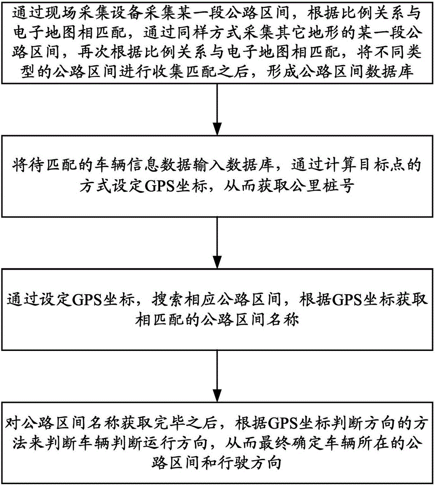
[0028] Embodiments of the present invention are described in detail below, examples of which are shown in the drawings, wherein the same or similar reference numerals designate the same or similar elements or elements having the same or similar functions throughout. The embodiments described below by referring to the figures are exemplary only for explaining the present invention and should not be construed as limiting the present invention.

[0029] In describing the present invention, it should be understood that the terms "longitudinal", "transverse", "upper", "lower", "front", "rear", "left", "right", "vertical", The orientation or positional relationship indicated by "horizontal", "top", "bottom", "inner", "outer", etc. are based on the orientation or positional relationship shown in the drawings, and are only for the convenience of describing the present invention and simplifying the description, rather than Nothing indicating or implying that a referenced device or elem...


PUM


Abstract

The invention provides a highway mileage stake number determining method based on an electronic map and a GPS coordinate. The method comprises the steps of S1, acquiring a certain highway segment through field acquisition equipment, performing matching with the electronic map according to a proportional relationship, acquiring a certain highway segment of another landform in a same manner, performing matching with the electronic map according to the proportional relationship, performing collection matching on highway segments in different types, and forming a highway segment database; S2, inputting to-be-matched vehicle information data into the database, and setting a GPS coordinate in a manner of calculating a target point, thereby obtaining a mileage stake number; S3, searching a corresponding highway segment through setting the GPS coordinate, and acquiring a matched highway segment name according to the GPS coordinate; and S4, after acquiring the highway segment name, determining a vehicle driving direction in a method of determining the direction according to the GPS coordinate, thereby finally determining the highway segment in which the vehicle exists and the driving direction.

Description

technical field [0001] The invention relates to the field of computers, in particular to a method for determining highway kilometer stake numbers based on electronic maps and GPS coordinates. Background technique [0002] Once a traffic accident occurs on passenger cars and hazardous chemical vehicles, it is likely to cause a large number of casualties and road property losses. Among them, speeding is an important cause of traffic accidents. Therefore, speeding penalties for passenger cars and hazardous chemical vehicles are the focus of the supervision of the traffic police department. The superior management company of this type of vehicle generally installs a GPS device in the vehicle and transmits the GPS data back to the company in real time. The traffic police department can extract relevant data and impose penalties on speeding behavior. The extracted data includes time, latitude and longitude, and vehicle speed. However, when the traffic police issue a penalty notice...

Claims


Application Information

Patent Timeline
Patent Type & Authority Applications(China)
IPC IPC(8): G01S19/42G01C21/30
Inventor 邱金龙尹志勇刘文君苏森李奎夏兵
Owner THE THIRD AFFILIATED HOSPITAL OF THIRD MILITARY MEDICAL UNIV OF PLA
Why Eureka
Try Eureka