Fast and accurate centimeter-level single point positioning method

An accurate, single-point technology, applied in satellite radio beacon positioning systems, measuring devices, instruments, etc., can solve problems such as low accuracy of earth coordinate measurement data, limited single-point positioning measurement accuracy, and greater influence of data accuracy. Achieve the effect of achieving rapid convergence, reducing possibility, and improving accuracy

Active Publication Date: 2017-06-09
LINKSILICON INNOVATION PTE +1
View PDF16 Cites 4 Cited by
  • Summary
  • Abstract
  • Description
  • Claims
  • Application Information

AI Technical Summary

Problems solved by technology

However, the convergence time of this method is usually as long as several days. If the positioning time is too long, factors such as weather, atmosphere, satellite position, and earth tides will have a greater impact on the data accuracy. This limits the measurement accuracy of single-point positioning and affects the measurement accuracy. limited improvement
The surveying and mapping industry usually uses differential positioning equipment for centimeter-level and millimeter-level high-precision measurement. The relative distance measurement accuracy of the differential positioning system is very high, but if you want to accurately measure the position coordinates, you need to differentiate the coordinates of a known point to obtain the coordinates of the target point. Most of the coordinates of known points are obtained by single-point positioning, so the coordinates obtained by the differential positioning system are accurate relative to known points, but have a large error relative to the reference origin of the earth coordinate system
[0003] This manual will detail a fast and accurate single-point satellite positioning method to solve the above-mentioned problems such as low accuracy of earth coordinate measurement data and long positioning time of current single-point positioning and differential positioning equipment, and realize centimeter-level accurate earth coordinate measurement of a single point

Method used


Image

  • Fast and accurate centimeter-level single point positioning method
  • Fast and accurate centimeter-level single point positioning method

Examples


Embodiment Construction

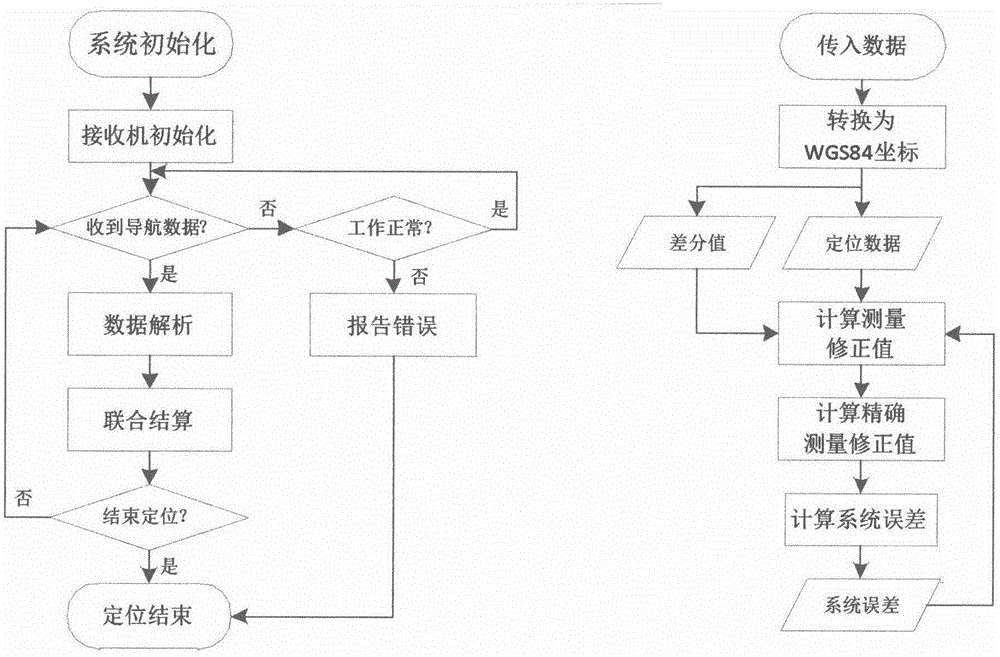
[0052] The specific steps of the fast and accurate single-point positioning method in the embodiment of the present invention are as follows:

[0053] Step 1: After the system is powered on, the measurement and control host assigns the initial value X to each positioning system parameter C =0, ρ=0, X K = 0, X KK =0, and initialize the data receiving unit.

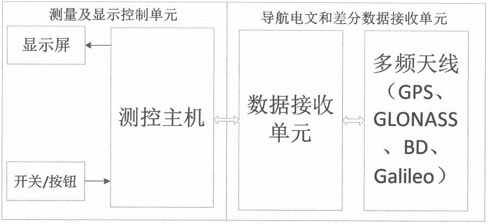
[0054] Step 2: After confirming that the multi-frequency antenna is working normally, the data receiving unit receives the navigation messages and interstellar difference correction data of multiple systems and unifies them into longitude, latitude and elevation data X under WGS84 coordinates C , and transmit the data to the measurement and control host;

[0055] Step 3: The measurement and control host receives the coordinate data X uploaded by the data receiving unit C , will locate the data X C and the iteratively accumulated interstellar difference correction data ρ are brought into formula (15) to calculate and ob...


PUM


Abstract

The invention relates to a fast and accurate centimeter-level single point positioning method, so as to solve the problems that the existing satellite positioning system is poor in positioning accuracy, long in positioning time and largely influenced by weather and position factors. According to the technical scheme for the fast and accurate single point positioning method of the invention, a multi-band antenna is used for receiving a multisystem navigation message and interstellar differential correction data, a receiver initially processes and coverts the navigation message and the correction data to coordinates in a WGS84 coordinate system, and a control system carries out joint solution on the coordinate data to acquire accurate positioning data. The method has the beneficial effects that coordinate measurement with the accuracy within 10cm in 30 minutes in a condition with no blocking around can be realized, and defects of the market are remedied.

Description

technical field [0001] The invention relates to the technical fields of satellite positioning and interstellar differential positioning. Background technique [0002] The positioning accuracy of traditional civilian satellite single-point positioning equipment is generally about 5 to 10 meters, and the positioning accuracy of military positioning equipment can reach up to about 1 meter. If you need to obtain higher single-point positioning measurement accuracy data, you can receive positioning measurement data at a fixed measurement position for a long time, and converge the measurement accuracy through the average value algorithm to achieve higher-precision single-point positioning measurement data. However, the convergence time of this method is usually as long as several days. If the positioning time is too long, factors such as weather, atmosphere, satellite position, and earth tides will have a greater impact on the data accuracy. This limits the measurement accuracy of...

Claims


Application Information

Patent Timeline
Patent Type & Authority Applications(China)
IPC IPC(8): G01S19/33G01S19/37
CPCG01S19/33G01S19/37
Inventor 郭阳斌尹一志曹放华周正宇李小林杨彦龙经锋
Owner LINKSILICON INNOVATION PTE
Why Eureka
Try Eureka