A method and device for reviewing cultivated land occupation and compensation space

A technology for filling space and cultivated land, applied in the field of cultivated land resources management, can solve problems such as low efficiency and precision errors

Active Publication Date: 2020-07-07
宁波市农业技术推广总站
View PDF4 Cites 0 Cited by
  • Summary
  • Abstract
  • Description
  • Claims
  • Application Information

AI Technical Summary

Problems solved by technology

[0005] The present invention provides a method and device for reviewing cultivated land occupation and compensation space, aiming to solve the problem of precise errors that are prone to occur due to the use of single-layer superimposition combined with manual measurement to obtain the superimposed area by sequentially superimposing cultivated land layers in actual operation and low efficiency

Method used


Image

  • A method and device for reviewing cultivated land occupation and compensation space
  • A method and device for reviewing cultivated land occupation and compensation space
  • A method and device for reviewing cultivated land occupation and compensation space

Examples


Embodiment 1

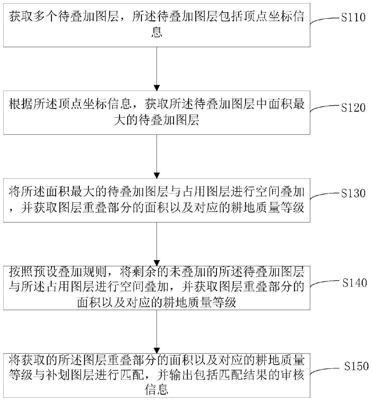
[0034] figure 2 It shows the implementation flow chart of a method for auditing cultivated land occupation and compensation space provided by the embodiment of the present invention, and is described in detail as follows:

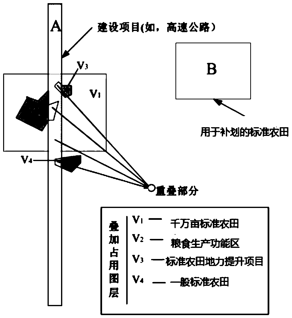
[0035] In step S110, multiple layers to be superimposed are acquired, and the layers to be superimposed include vertex coordinate information.

[0036] In the embodiment of the present invention, the layer to be superimposed is a polygonal layer formed by scaling down the actual cultivated land according to different types of cultivated land.

[0037] In the embodiment of the present invention, the formed polygonal layer is entered into the occupied layer data and supplementary layer data in the SHP file format with a common coordinate system in the terminal, and according to the position of the layer to be superimposed, The coordinate information of each vertex of the layer to be superimposed can be read according to the coordinate system.

[0038] In s...

Embodiment 2

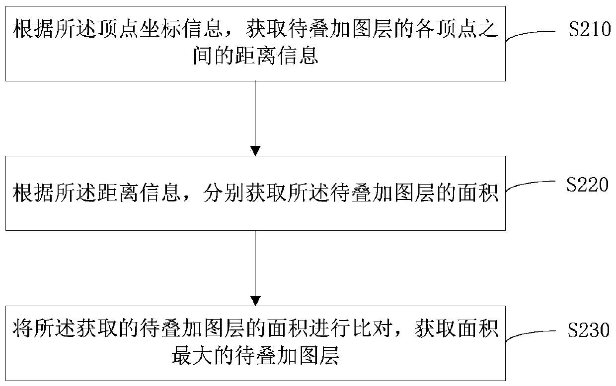
[0060] image 3 It shows the implementation process of a method for obtaining the layer to be superimposed with the largest area provided by the embodiment of the present invention, which is similar to Embodiment 1, except that the method for obtaining the layer to be superimposed is obtained according to the vertex coordinate information. The layer to be superimposed with the largest area in the layer, including:

[0061] In step S210, according to the vertex coordinate information, the distance information between vertices of the layer to be superimposed is obtained.

[0062] In the embodiment of the present invention, after importing multiple layers to be superimposed, a layer is arbitrarily selected, and the coordinate information of any two adjacent vertices in the closed polygon of the layer in the coordinate system of the current plane is read, And according to the plane coordinate information, the distance information between the two vertices is obtained according to ...

Embodiment 3

[0076] Figure 4 It shows the implementation process of another method for reviewing cultivated land occupation and replenishment space provided by the embodiment of the present invention, which is similar to the first embodiment, except that the layer to be superimposed is obtained according to the vertex coordinate information The layer to be overlaid with the largest area, and then includes:

[0077] In step S310, the layer to be superimposed with the largest area and the layers to be superimposed included in the layer to be superimposed with the largest area are generated as priority packaging layers.

[0078] In the embodiment of the present invention, after the layer to be superimposed with the largest area is obtained through the first preset algorithm and the second preset algorithm, the layer to be superimposed with the largest area and the layer to be superimposed with the largest area are The other layers to be superimposed included on the above are generated as pr...


PUM


Abstract

The present invention is applicable to the field of cultivated land resources management, and provides a method and device for reviewing cultivated land occupation and compensation space. The method includes: acquiring a plurality of layers to be superimposed, and the layers to be superimposed include vertex coordinate information; according to the vertex coordinate information , to obtain the layer to be superimposed with the largest area among the layers to be superimposed; spatially superimpose the layer to be superimposed with the largest area and the occupied layer, and obtain the area of ​​the overlapping part of the layer and the corresponding cultivated land quality level; superimpose according to the preset The rule is to spatially superimpose the remaining unsuperimposed layers to be superimposed and the occupied layers, and obtain the area of ​​the overlapped part of the layers and the corresponding cultivated land quality grade; the obtained area of ​​the overlapped part of the layers And the corresponding cultivated land quality grade is matched with the supplementary layer, and the audit information including the matching result is output. Accurate calculation of the spatial area of ​​the superimposed part of various layer data by the above method can improve the review efficiency and accuracy.

Description

technical field [0001] The invention belongs to the field of cultivated land resources management, and in particular relates to a method and device for reviewing occupied and supplemented space of cultivated land. Background technique [0002] Cultivated land is the basic resource for human survival and development, the basic element of grain production capacity, and the cornerstone of national food security. In recent years, with economic and social development, urbanization has accelerated, and constraints on cultivated land resources have tightened. In the face of the current severe situation of cultivated land resources, strengthening the protection of cultivated land with "equal emphasis on quantity and quality" and strict balance management of cultivated land occupation and compensation are important foundations for ensuring national food security and promoting healthy agricultural development under the new situation. An important task of the strategy of storing food ...

Claims


Application Information

Patent Timeline
Patent Type & Authority Patents(China)
IPC IPC(8): G06T5/50
CPCG06Q50/02G06F18/22
Inventor 秦方锦王飞邓勋飞刘桂良陈少杰葛超楠马建芳王剑徐静高张欢王先挺刘荣杰王斌翁颖陈宇博洪可蔚
Owner 宁波市农业技术推广总站
Why Eureka
Try Eureka