Orthoimage tessellation line network automatic selection method based on building roof vector

An orthophoto and automatic selection technology, applied in image enhancement, image analysis, image data processing, etc., can solve the problem of not giving the optimal selection of the mosaic line network in the survey area, unable to ensure that the mosaic line bypasses the building, no Considering the problem of image enlargement, etc., the effects of reducing large projection deformation at the edge of the image, high accuracy, and small projection deformation are achieved.

Active Publication Date: 2017-06-13
CHONGQING GEOMATICS & REMOTE SENSING CENT
View PDF2 Cites 5 Cited by
  • Summary
  • Abstract
  • Description
  • Claims
  • Application Information

AI Technical Summary

Problems solved by technology

This type of method is essentially pixel-level, the difference is expressed in a single pixel, and the ground features with geometric differences are not expressed as a whole, so the mosaic line will inevitably pass through areas such as buildings, and the algorithm is very complicated and inefficient; The second type is to bypass buildings by automatically searching auxiliary mosaic lines such as DSM or building mapping data
However, the above methods do not take into account that the projection deformation of the image becomes larger towards the edge of the image.
At the same time, most methods only optimize the selection of the mosaic lines between adjacent images, and do not give the optimal selection scheme of the mosaic line network in the entire survey area.
[0006] The Voronoi diagram mosaic line network automatically generated based on the positional relationship of the sequence images can well select the part with the smallest projected deformation on each image as the effective mosaic area, but it cannot guarantee that the mosaic line bypasses the building

Method used


Image

  • Orthoimage tessellation line network automatic selection method based on building roof vector
  • Orthoimage tessellation line network automatic selection method based on building roof vector
  • Orthoimage tessellation line network automatic selection method based on building roof vector

Examples


Embodiment Construction

[0066] The specific implementation manner and working principle of the present invention will be further described in detail below in conjunction with the accompanying drawings.

[0067] In this example, the aerial image samples used are 32 aerial image samples of 4 flight belts in an urban area with a resolution of 0.1m, a heading overlap of about 60%, a side overlap of about 45%, and a size of 8230*6168. image.

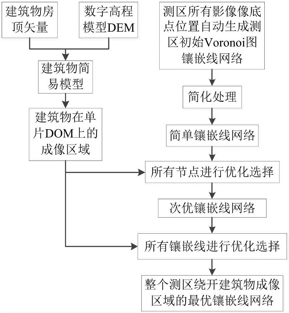
[0068] Such as figure 1 As shown, an automatic selection method of orthophoto mosaic line network based on building roof vector, the specific steps are as follows:

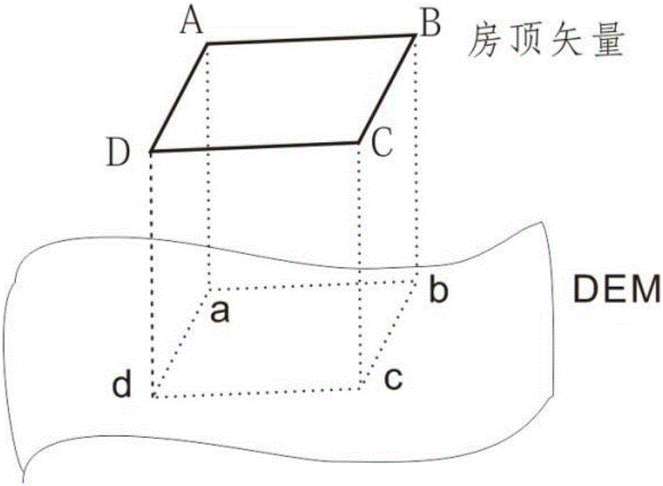
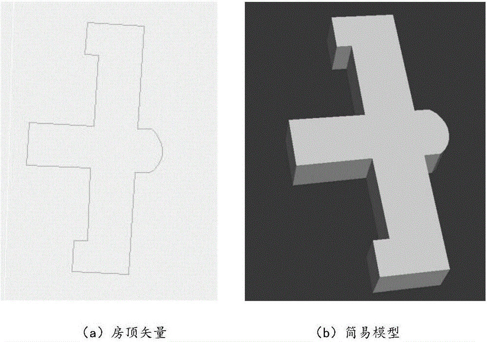
[0069] Step 1: The roof vector of the building is combined with the digital elevation model DEM to automatically generate a simple model of the building, specifically:

[0070] In the stage of photogrammetry stereo mapping, the roof vector lines obtained by constructing a stereo model through a stereo image pair and then performing stereo mapping, they not only have two-dimensional XY coordinates, but...


PUM


Abstract

The invention discloses an orthoimage tessellation line network automatic selection method based on a building roof vector. The method comprises the steps of making the building roof vector combine with a digital elevation model (DEM) to automatically generate a building simple model; utilizing the building simple model to calculate an imaging area of a building on a single-chip DOM; automatically generating a testing area initial Voronoi image tessellation line network using positions of pixel nadir points of all images in a measuring area and conducting simplified processing; using the imaging area of the building on the single-chip DOM to conduct optimized selection on all nodes to obtain a sub-optimal tessellation line network; then conducting optimized selection on all tessellation lines in the sub-optimal tessellation line network to obtain an optimal tessellation line network bypassing the imaging area of the building, of the whole measuring area. The orthoimage tessellation line network automatic selection method based on the building roof vector has obvious advantages that a traditional mode in which single ortho-rectification is firstly conducted, then the single-chip DOM is utilized to conduct selection of the tessellation line network is broken through, and the problems that texture malposition occurs caused when the tessellation line network in the measuring area cannot automatically bypass the imaging area of the building and the automatic selection efficiency is low in an existing method are solved.

Description

technical field [0001] The invention relates to the technical field of aerial orthoimage mosaic, in particular to an automatic selection method of orthoimage mosaic line network based on building roof vectors. Background technique [0002] Digital Orthophoto Map (DOM for short) is a digital remote sensing image using a digital elevation model (Digital Elevation Model for short DEM), after digital differential correction of a single image, then mosaic fusion, and finally cut according to a certain map size digital image data. DOM is one of the important 4D products of digital photogrammetry and remote sensing. It is also an important data source for the production and update of basic geographic information data. Urban construction and other fields. With the development of UAV low-altitude remote sensing system, DOM is also playing an increasingly important role in natural disaster rapid disaster assessment and emergency rescue. [0003] The production of DOM image maps mai...

Claims


Application Information

Patent Timeline
Patent Type & Authority Applications(China)
IPC IPC(8): G06T3/40G06T5/50
CPCG06T3/4038G06T5/50G06T2207/10032G06T2207/20221
Inventor 李朋龙丁忆徐永书胡艳张治清金贤锋李胜卢涛李静李碧香肖勇罗鼎蒲德祥张少佳段松江吴凤敏
Owner CHONGQING GEOMATICS & REMOTE SENSING CENT
Why Eureka
Try Eureka