Positioning routing method and device based on ultrawideband signal

An ultra-broadband, path-finding technology, used in positioning, measuring devices, instruments, etc., can solve the problems of inability to find the path of the target outside the line of sight, limited robot application scenarios, and low positioning and path-finding accuracy.

Inactive Publication Date: 2017-06-30
深圳蓝因机器人科技有限公司
View PDF12 Cites 4 Cited by
  • Summary
  • Abstract
  • Description
  • Claims
  • Application Information

AI Technical Summary

Problems solved by technology

[0007] The main purpose of the present invention is to provide a positioning and path-finding method and device based on ultra-wideband signals, aiming at solving the problem that the current positioning and path-finding accuracy is not high and cannot locate targets outside the radar or camera line of sight, and cannot perform path-finding for targets outside the line of sight Mobile, limited robot application scenarios and other issues

Method used


Image

  • Positioning routing method and device based on ultrawideband signal
  • Positioning routing method and device based on ultrawideband signal
  • Positioning routing method and device based on ultrawideband signal

Examples


no. 1 example

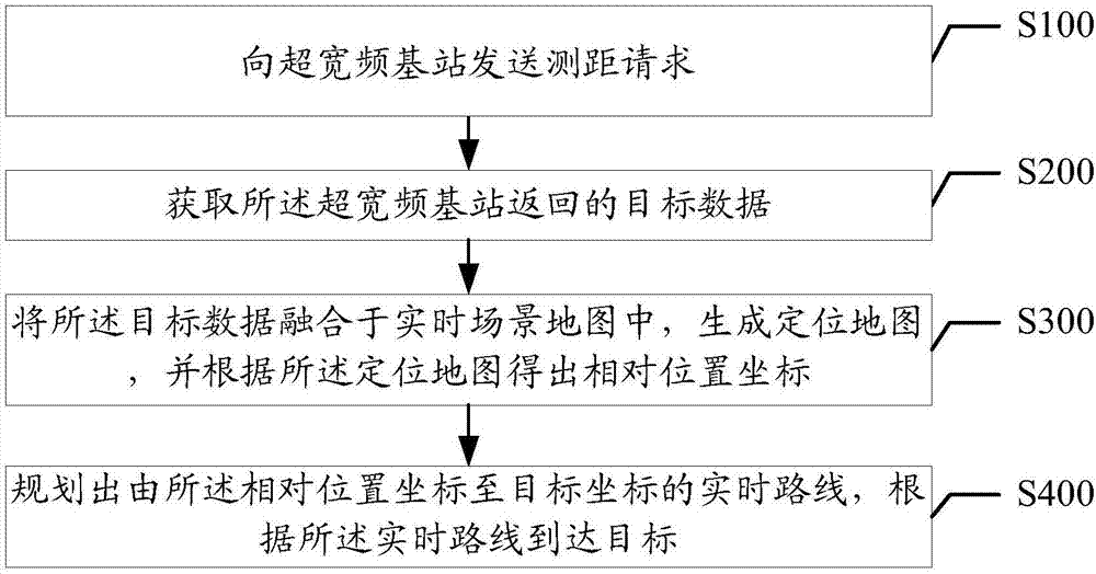
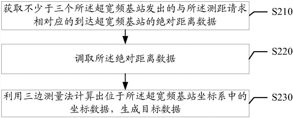
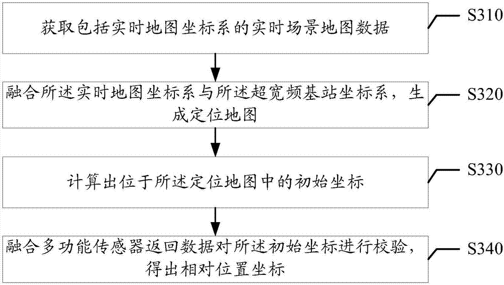
[0066] Based on the first embodiment of the above-mentioned ultra-wideband signal-based positioning and routing method, the step S200 includes:

[0067] Step S210, acquiring the absolute distance data corresponding to the ranging request sent by no less than three ultra-wideband base stations to the ultra-wideband base station.

[0068] Step S220, calling the absolute distance data;

[0069] Step S230, using the trilateration method to calculate the coordinate data located in the coordinate system of the ultra-wideband base station to generate target data.

[0070] In this embodiment, the coordinates of the target data are inferred by the trilateration method, and the receiver receives the distance data of at least 3 base stations, and uses the trilateration method to calculate its coordinates in the base station coordinate system. What needs to be understood is that trilateration is a method of laying out a series of continuous triangles on the ground, and measuring the hori...


PUM


Abstract

The invention provides a positioning routing method based on an ultrawideband signal. The method comprises the following steps: sending a ranging request to an ultrawideband base station; to obtain target data returned by the ultrawideband base station; fusing the target data in a real-time scene map, generating a positioning map, and getting a relative position coordinate according to the positioning map; and planning a real-time path from the relative position coordinate to a target coordinate, and arriving the target according to the real-time path. The invention further provides a positioning routing device based on the ultrawideband signal. The method is capable of completing the accurate space positioning by using a minitype ultrawideband signal device, not only effectively reducing the power consumption, but also greatly saving the calculation resources, and completely eliminating the time of running the complicated calculation so as to execute the task efficiently. The method is capable of accurately positioning and routing the different target users in the different running scenes so as to execute the specific service task.

Description

technical field [0001] The invention relates to the technical field of robot positioning, in particular to a positioning and path-finding method and device based on ultra-wideband signals. Background technique [0002] With the maturity of robot technology, the procurement cost of major internal components will gradually decrease, and it will become possible to put a large number of robots into commercial and service fields in the next few years. Regardless of the type of robot, its positioning in space, autonomous navigation, and positioning of target users are one of the most basic and important functions. [0003] At present, the realization of autonomous positioning and navigation is mainly through the fusion and calculation of the information fed back by radar, camera, acceleration sensor, gyroscope, pedometer and other sensors to obtain its own estimated position, and then plan the movement path and execute the task according to the target position. As for the target ...

Claims


Application Information

Patent Timeline
Patent Type & Authority Applications(China)
IPC IPC(8): G01C21/00G01S5/02G01S5/16
CPCG01C21/005G01S5/02G01S5/16
Inventor 陈卜铭邹选霖陈英达孙集林
Owner 深圳蓝因机器人科技有限公司
Why Eureka
Try Eureka