Rotation domain polarimetric zero angle characteristic-based polarimetric SAR terrain classification method

A technology of polarization features and classification of ground objects, applied in computer parts, instruments, characters and pattern recognition, etc., can solve the problems of ambiguity and limited accuracy of scattering machine interpretation

Active Publication Date: 2017-06-30
NAT UNIV OF DEFENSE TECH
View PDF11 Cites 12 Cited by
  • Summary
  • Abstract
  • Description
  • Claims
  • Application Information

AI Technical Summary

Problems solved by technology

This is one of the important reasons why many traditional polarization target decomposition methods have ambiguity in the interpretation of scattering mechanisms, and it also limits the further improvement of the accuracy of traditional classification methods based on rotation-invariant polarization characteristic parameters

Method used


Image

  • Rotation domain polarimetric zero angle characteristic-based polarimetric SAR terrain classification method
  • Rotation domain polarimetric zero angle characteristic-based polarimetric SAR terrain classification method
  • Rotation domain polarimetric zero angle characteristic-based polarimetric SAR terrain classification method

Examples


Embodiment Construction

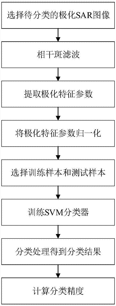
[0060] In order to better understand the technical solutions of the present invention, the implementation manners of the present invention will be further described below in conjunction with the accompanying drawings.

[0061] figure 1 It is an implementation flowchart of the present invention, mainly including eight specific steps.

[0062] The first step is to select the polarimetric SAR image to be classified; the following is the polarimetric coherence matrix T 0 Introduce as an example. Each pixel in the polarimetric SAR image corresponds to a polarimetric coherence matrix, denoted as i=1,2,...,I; j=1,2,...,J, the size of the polarimetric SAR image is I×J. The polarization coherence matrix of each pixel to be classified in the polarization SAR image Carry out the processing of the second and third steps below.

[0063] The second step is coherence speckle filtering; in the embodiment, the literature Si-Wei Chen, Xue-Song Wang and Motoyuki Sato, "PolInSAR complex co...


PUM


Abstract

The invention belongs to the technical field of full polarimetric synthetic aperture radar imaging remote sensing and relates to a rotation domain polarimetric zero angle characteristic-based polarimetric SAR terrain classification method. The method mainly comprises eight specific steps. In a first step, polarimetric SAR images to be classified are chosen; in a second step, coherent speckle filtering operation is conducted; in a third step, polarimetric characteristic parameters are extracted, and polarimetric characteristic parameters corresponding to all pixel points are extracted based on filtered polarimetric SAR images; in a fourth step, polarimetric characteristic parameters are normalized; in a fifth step, training samples and testing samples are chosen; in a sixth step, an SVM classifier is trained; in a seventh step, classifying operation is conducted, and a classifying result is output; in an eighth step, classification precision is calculated. The method is simple to implement and has good robustness for polarimetric SAR image data of different time phases, and the method can be directly used for conducting terrain classification operation on polarimetric SAR image data of different time phases obtained from all kinds of polarimetric SAR systems.

Description

technical field [0001] The invention belongs to the technical field of full-polarization synthetic aperture radar (Synthetic Aperture Radar, SAR) imaging remote sensing, and relates to a polarized SAR ground object classification method combined with the polarization zero-angle feature of a rotation domain. Background technique [0002] Polarization SAR has all-weather and almost all-weather working capabilities, and obtains the full polarization scattering information of the target by sending and receiving electromagnetic waves with orthogonal polarization states. Land object classification is a common basic problem in application fields such as crop growth monitoring, rural and urban land census, and environmental monitoring. It is also an important application direction for polarimetric SAR image understanding and interpretation. The purpose of polarimetric SAR surface object classification is to use the polarimetric measurement data obtained by airborne or spaceborne SAR...

Claims


Application Information

Patent Timeline
Patent Type & Authority Applications(China)
IPC IPC(8): G06K9/62
CPCG06F18/2411G06F18/214
Inventor 陈思伟陶臣嵩李永祯王雪松
Owner NAT UNIV OF DEFENSE TECH
Why Eureka
Try Eureka