Autonomous navigation method of aircraft and system
A technology of autonomous navigation and navigation method, which is applied in the directions of ground navigation, radio wave measurement system, satellite radio beacon positioning system, etc. Switching, improving reliability, solving the effect of data mutation
- Summary
- Abstract
- Description
- Claims
- Application Information
AI Technical Summary
Problems solved by technology
Method used
Image
Examples
Embodiment 1
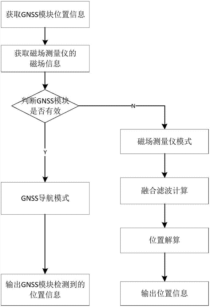
[0055] See figure 1 , Is a schematic diagram of the flow chart of the aircraft autonomous navigation method in the present invention. The specific process of the aircraft autonomous navigation method in the present invention will be described according to the flowchart. The specific steps of the aircraft autonomous navigation method are as follows:
[0056] S1. Obtain the position information detected by the GNSS module in a cycle;
[0057] S2. Obtain the magnetic field information detected by the magnetic field measuring instrument periodically;
[0058] S3. Determine whether the GNSS module is valid according to the location information of the GNSS module:
[0059] If the GNSS module is valid, set the aircraft to GNSS navigation mode and navigate according to the position information output by the GNSS module;
[0060] If the GNSS module is invalid, set the aircraft to the magnetic field measuring instrument navigation mode and go to step S4;
[0061] S4. Calculate the position of the...
Embodiment 2
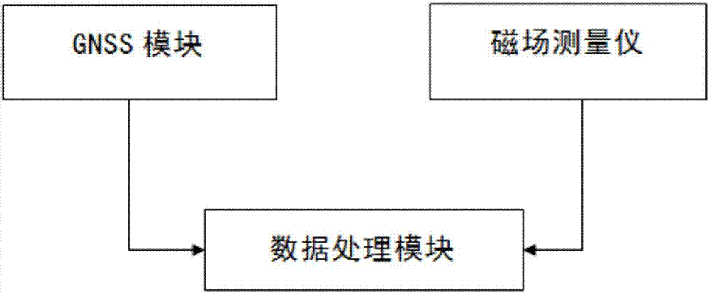
[0087] The invention also provides an autonomous navigation system for an aircraft, see figure 2 The autonomous navigation system of the aircraft includes a GNSS module, a magnetic field measuring instrument and a data processing module. The GNSS module detects the position information of the aircraft and sends the position information of the aircraft to the data processing module periodically; the magnetic field measuring instrument detects the magnetic field information and position information, and The magnetic field information and position information are sent to the data processing module periodically; the data processing module judges whether the GNSS module is valid according to the position information of the GNSS module, and according to the position information of the aircraft detected by the GNSS module and the magnetic field information detected by the magnetic field measuring instrument , Calculate the position of the aircraft, calculate the position information o...
PUM
 Abstract
Description
Claims
Application Information
 - R&D
- Intellectual Property
- Life Sciences
- Materials
- Tech Scout
- Unparalleled Data Quality
- Higher Quality Content
- 60% Fewer Hallucinations
Browse by: Latest US Patents, China's latest patents, Technical Efficacy Thesaurus, Application Domain, Technology Topic, Popular Technical Reports.
© 2025 PatSnap. All rights reserved.Legal|Privacy policy|Modern Slavery Act Transparency Statement|Sitemap|About US| Contact US: help@patsnap.com


