System and method for deploying servers
A technology for deploying servers and servers, which is applied to deploying servers and deploying geoserver to the field of cloud service platforms, which can solve problems such as delays in displaying map tiles, slow map tile speed, and affecting the real-time reception of clients.
- Summary
- Abstract
- Description
- Claims
- Application Information
AI Technical Summary
Problems solved by technology
Method used
Image
Examples
Embodiment 1
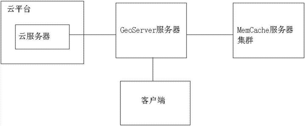
[0036] According to attached figure 1 It can be seen that the system for deploying servers in this embodiment includes a GeoServer server that communicates with the cloud server and the client of the cloud platform, the GeoServer server has a tile map service module GeoWebCache, and the GeoServer server also has a Mapping table, storage module and read module.
[0037] The method for deploying a server system includes the following steps:
[0038] Step 1: When the client sends a map access request to the GeoServer server to request a map, after the GeoServer server receives the map access request, it starts the reading module and searches in the mapping table whether there is a map access request corresponding to the received map access request. consistent map access requests;
[0039] Step 2: If there is a consistent map access request, extract all the mapping records including the map access request and obtain map tiles from the MemCache server or cloud server according to...
Embodiment 2
[0044] According to attached figure 1 It can be seen that the system for deploying servers in this embodiment includes a GeoServer server that communicates with the cloud server and the client of the cloud platform, the GeoServer server has a tile map service module GeoWebCache, and the GeoServer server also has a Mapping table, storage module and read module.
[0045] The GeoServer server communicates with a MemCache server cluster with a plurality of MemCache servers, and each of the MemCache servers is assigned a number.
[0046] The mapping table is used to record the map access request, the read times of the map access request, the map tile identification required by the map access request, the map tile serial number, the number of the MemCache server storing the map tile, the map The storage address of the tile in the MemCache server and the mapping relationship of the storage address of the map tile in the cloud server, the storage module is used to store the map tile ...
Embodiment 3
[0066] According to attached figure 1 It can be seen that the system for deploying servers in this embodiment includes a GeoServer server that communicates with the cloud server and the client of the cloud platform, the GeoServer server has a tile map service module GeoWebCache, and the GeoServer server also has a Mapping table, storage module and read module.
[0067] The GeoServer server communicates with a MemCache server cluster with a plurality of MemCache servers, and each of the MemCache servers is assigned a number.
[0068] The mapping table is used to record the map access request, the read times of the map access request, the map tile identification required by the map access request, the map tile serial number, the number of the MemCache server storing the map tile, the map The storage address of the tile in the MemCache server and the mapping relationship of the storage address of the map tile in the cloud server, the storage module is used to store the map tile ...
PUM
 Abstract
Description
Claims
Application Information
 - R&D
- Intellectual Property
- Life Sciences
- Materials
- Tech Scout
- Unparalleled Data Quality
- Higher Quality Content
- 60% Fewer Hallucinations
Browse by: Latest US Patents, China's latest patents, Technical Efficacy Thesaurus, Application Domain, Technology Topic, Popular Technical Reports.
© 2025 PatSnap. All rights reserved.Legal|Privacy policy|Modern Slavery Act Transparency Statement|Sitemap|About US| Contact US: help@patsnap.com


