GPSINS combination navigation method and system utilizing neural network algorithm to realize compensation and correction

A neural network algorithm and integrated navigation technology, applied in the field of integrated navigation compensation and correction, can solve the problems of satellite signal loss and large navigation data errors

Inactive Publication Date: 2017-07-25
GUANGZHOU BUREAU CSG EHV POWER TRANSMISSION
View PDF7 Cites 47 Cited by
  • Summary
  • Abstract
  • Description
  • Claims
  • Application Information

AI Technical Summary

Problems solved by technology

However, under some special environmental conditions, such as signal blocking areas and environments with many obstacles, satellite signals may be lost...

Method used


Image

  • GPSINS combination navigation method and system utilizing neural network algorithm to realize compensation and correction
  • GPSINS combination navigation method and system utilizing neural network algorithm to realize compensation and correction
  • GPSINS combination navigation method and system utilizing neural network algorithm to realize compensation and correction

Examples


Embodiment Construction

[0022] The following is a clear and complete description of the technical solutions in the embodiments of the present invention in conjunction with the accompanying drawings and embodiments. Obviously, the described embodiments are only some of the embodiments of the present invention, not all of them.

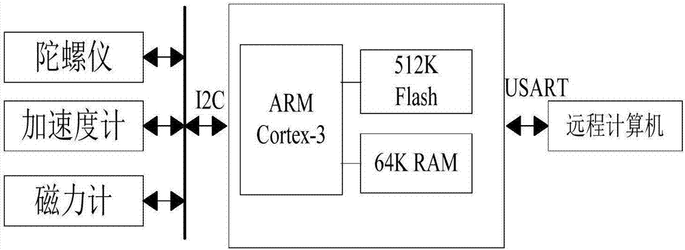
[0023] see figure 1 , is a GPSINS integrated navigation system utilizing neural network algorithm compensation and correction of the present invention, the navigation system includes a control unit, in the present embodiment, the control unit adopts the ARM Cortex-M3 kernel, and the STM32 development board based on the kernel A gyroscope, an accelerometer, and a magnetometer are connected in an I2C manner (internal integrated circuit communication connection). In this embodiment, the gyroscope uses an MPU9250 nine-axis inertial sensor module, and the magnetometer uses an AK8963 magnetometer. Gyroscope and magnetometer produce inertial navigation data, and transmit to control u...


PUM


Abstract

The invention discloses a GPSINS combination navigation method and system utilizing a neural network algorithm to realize compensation and correction. The method comprises steps that a combination navigation model based on a GPS and an inertial navigation module is constructed, a Kalman filter is designed to filter combination navigation data of the combination navigation model, and navigation error data of the inertial navigation module is outputted; in a normal GPS signal state, inertial navigation data is taken as input data of a training sample of a neural network model, output data of the navigation data after filtered by the Kalman filter is taken as output data of a training sample of a neural network module, and the neural network model is trained; in a GPS signal loss state, the trained neural network model is utilized to predict an output error of the inertial navigation module, and the predicted output error is further utilized to compensate and correct inertial navigation. The method is advantaged in that the GPSINS combination navigation model is compensated and corrected through utilizing the neural network algorithm, and the inertial navigation system is assisted by the neural network algorithm to output the accurate navigation data in the GPS signal loss state.

Description

technical field [0001] The present invention relates to the field of satellite navigation and inertial navigation, in particular to a method and system for compensating and correcting integrated navigation under the condition of GPS signal loss of UAV by using neural network algorithm. Background technique [0002] In terms of navigation technology, currently the most widely used, the most mature navigation methods are inertial navigation and satellite navigation. The advantage of GPS satellite navigation is that it has the characteristics of global, all-weather, and high positioning accuracy for a long time, but the disadvantage is that the signal is easily interfered and blocked. Limited, generally 1-10Hz, the output is discontinuous. In the occasions that need to update information quickly, such as UAV systems with high mobility and real-time requirements, the shortcomings of GPS satellite navigation will be highlighted. The INS inertial navigation system is a fully auto...

Claims


Application Information

Patent Timeline
IPC IPC(8): G01S19/49G01C21/16G01C21/00G01C21/18G06N3/02
CPCG01C21/005G01C21/165G01C21/18G01S19/49G06N3/02
Inventor 郑武略尚涛张富春张蔓翁珠奋焦炯焦海龙赵付亮赵雪峰金钊梁伟昕林翔宋丹马智梁超刘延超李如凰贾培亮
Owner GUANGZHOU BUREAU CSG EHV POWER TRANSMISSION
Why Eureka
Try Eureka