Large-scale underwater network positioning method based on recursion position estimation

A network positioning, large-scale technology, applied in measurement devices, open-air water source surveys, complex mathematical operations, etc., can solve problems such as low positioning accuracy and small coverage, achieve good applicability, high network coverage, and improve network average. The effect of positioning accuracy

Active Publication Date: 2017-08-18
HARBIN ENG UNIV
View PDF5 Cites 3 Cited by
  • Summary
  • Abstract
  • Description
  • Claims
  • Application Information

AI Technical Summary

Problems solved by technology

[0005] The purpose of the present invention is to propose a large-scale underwater network positioning method based on recursiv...

Method used


Image

  • Large-scale underwater network positioning method based on recursion position estimation
  • Large-scale underwater network positioning method based on recursion position estimation
  • Large-scale underwater network positioning method based on recursion position estimation

Examples


Embodiment 1

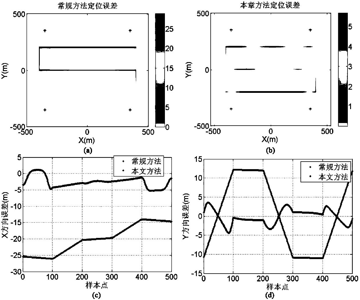
[0110] The accuracy of the results of the method proposed by the present invention and the conventional intersection solution method is compared.

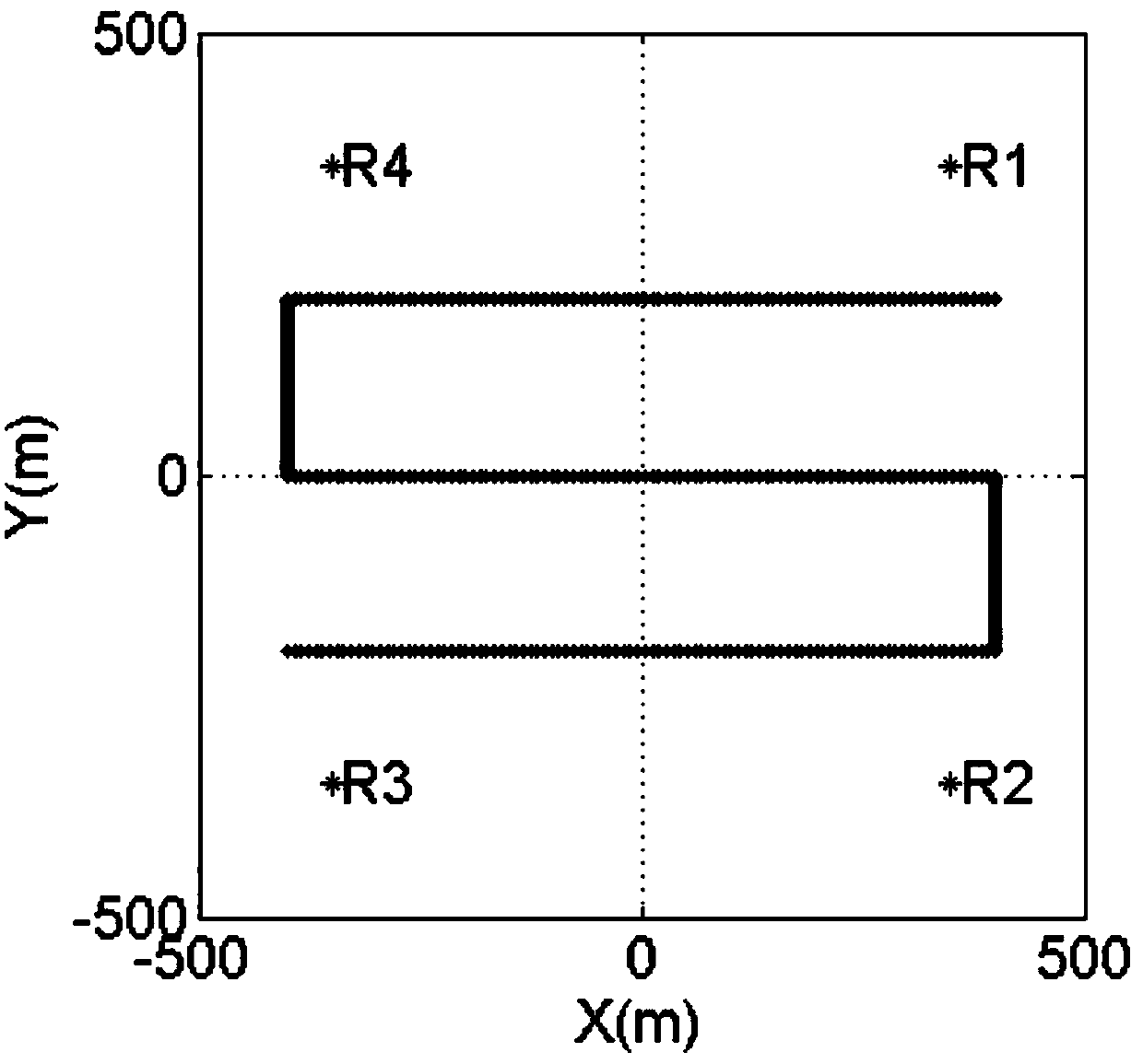
[0111] Four reference nodes are used in the simulation. Since the underwater sensor nodes are equipped with pressure sensors, the depth information is used as a known quantity in the following simulation, and the corresponding underwater positions are R1 (350m, 350m), R2 (350m, -350m ), R3 (-350m, -350m), R4 (-350m, 350m). Ordinary nodes are in the area surrounded by reference nodes, and the horizontal movement trajectory is as follows: figure 2 shown. In the simulation, a random error of 0.1m as the standard deviation is added to the distance measurement, and a positioning error of 10m is introduced to the 4 reference nodes, and the position coordinates of the 4 reference nodes are obtained as R1 (360m, 360m), R2 (340m, -340m), R3 (-360 m, -360m), R4 (-340m, 340m), take the above coordinates as a reference for common node posit...

Embodiment 2

[0116] The selection criteria of two traditional common nodes upgraded to reference nodes are compared with the selection criteria of the present invention, and the average positioning error and network coverage of network nodes are simulated, and the results are as follows Figure 4 shown.

[0117] Four reference nodes are used in the simulation. Since the underwater sensor nodes are equipped with pressure sensors, the depth information is used as a known quantity in the following simulation, and the corresponding underwater positions are R1 (350m, 350m), R2 (350m, -350m ), R3 (-350m, -350m), R4 (-350m, 350m). Ordinary nodes are in the area surrounded by reference nodes, and the horizontal movement trajectory is as follows: figure 2 shown. In the simulation, a random error of 0.1m as the standard deviation is added to the distance measurement, and a positioning error of 10m is introduced to the 4 reference nodes, and the position coordinates of the 4 reference nodes are ob...


PUM


Abstract

The present invention belongs to the field of marine environment monitoring, and particularly relates to a large-scale underwater network positioning method based on recursion position estimation. The large-scale underwater network positioning method comprises: 1, determining the initial value of a common node to be positioned; 2, constructing an observation equation, the distance measurement error equation of the common node, and the coordinate error equation of a reference node; 3, calculating a weight matrix according to the positioning error and the distance measurement error of the reference node, adding the weight matrix to an adjustment solution model, and calculating to obtain a position evaluation value of the common node to be positioned; and 4, performing the step 2 again by using the calculated position evaluation value as the initial value of the calculation, terminating the calculation until the difference between the two position evaluation values is less than a threshold, using the result as the position evaluation value of the common node to be positioned, and the like. According to the present invention, by using the common node selection criterion based on the error propagation theory, the average positioning precision of the network is effectively improved, the high network coverage at the large scale and high node density is provided, and the good applicability is provided.

Description

technical field [0001] The invention belongs to the field of marine environment monitoring, and in particular relates to a large-scale underwater network positioning method based on recursive position estimation. Background technique [0002] Marine environment monitoring is an important part of marine resource detection, marine environmental scientific research and marine disaster warning. However, due to the drastic changes in the marine natural environment, marine disasters cause huge casualties and property losses, and the resulting economic losses seriously threaten the coastal economy. The development of the sea has brought great harm to the life and property of the people in the coastal areas and the production activities at sea. [0003] As the third platform for earth observation, the underwater sensor network can fully understand the scientific phenomena of the seabed, and complete tasks such as marine resource detection and marine engineering auxiliary constructio...

Claims


Application Information

Patent Timeline
IPC IPC(8): G01C13/00G06F17/11
Inventor 孙大军李海鹏韩云峰张居成郑翠娥王永恒
Owner HARBIN ENG UNIV
Why Eureka
Try Eureka