Extraction method for reservoir characteristic curve based on spatial information technology

A spatial information technology and characteristic curve technology, which can be applied to water resources assessment, open-air water source survey, and measurement devices, and can solve problems such as laborious, time-consuming, and expensive acquisition

Active Publication Date: 2017-08-18
STATE GRID CORP OF CHINA
View PDF5 Cites 20 Cited by
  • Summary
  • Abstract
  • Description
  • Claims
  • Application Information

AI Technical Summary

Problems solved by technology

[0004] The object of the present invention is to provide a method for extracting reservoir characteristic curves based on spatial information technology, comprehensively utilizing RS-based water body information extraction technology, GPS-based topographic measurement technology and GIS-based mapping technology, and DEM based on multi-source spatial dat

Method used


Image

  • Extraction method for reservoir characteristic curve based on spatial information technology
  • Extraction method for reservoir characteristic curve based on spatial information technology
  • Extraction method for reservoir characteristic curve based on spatial information technology

Examples


Embodiment 1

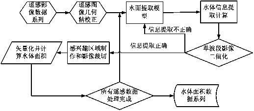
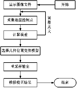
[0054] This embodiment is based on the spatial information technology Zhelin Reservoir dead water level ~ normal reservoir characteristic curve extraction method within the elevation range, the steps of the method described in this embodiment are as follows:

[0055] (1) Storage capacity curve extraction within the elevation range from dead water level to normal water storage level:

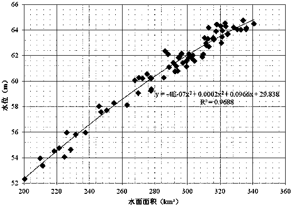
[0056] First, 110 Landsat satellite images were downloaded, and 71 Landsat image data with no cloud and good quality were selected for analysis, and the water level values ​​corresponding to the imaging time of these images were found in the water regime forecasting system, as shown in Table 1 below . Among them, the water level in front of the dam is the average value of the measured values ​​of the two water levels at 8:00 and 14:00 when the water level in the reservoir does not vary much. After comparing with the data recorded by the self-recording water level gauge at the same time, the self-...


PUM


Abstract

The invention discloses an extraction method for a reservoir characteristic curve based on a spatial information technology. The method comprehensively applies RS, GIS and GPS techniques and a digital elevation model. The method comprises the following steps: extracting a characteristic curve in a dead water level-normal pool level elevation scope based on remote-sensing image water information extraction and a GIS drawing technique, and extracting a characteristic curve in a normal pool level-maximum flood level elevation scope based on a GPS topographic surveying technique and a multi-source spatial data topography modeling technique. Compared with the present reservoir characteristic curve acquiring technique, the method disclosed by the invention has the advantages that a level-area and level-volume curve above the dead water level of the reservoir can be quickly, efficiently and accurately acquired, and the cost is low. Specific to the running reservoir, the method can conveniently check the original reservoir characteristic curve and has significance in reservoir flood preventing and power generation dispatching.

Description

technical field [0001] The invention relates to the technical fields of RS technology, GIS technology, GPS technology and hydrological calculation, in particular to a method for extracting characteristic curves of reservoirs based on spatial information technology. Background technique [0002] After the reservoir has been in operation for many years, there will be some problems of siltation at the bottom of the reservoir, especially for reservoirs built on sandy rivers. The siltation problem is more serious. If the reservoir characteristic curve during the construction of the reservoir dam is followed, the calculation result of the water balance of the reservoir will be affected. Cause flood control safety hazards and affect power generation efficiency. For the reservoirs that have been in operation, the traditional reservoir characteristic curve acquisition and verification method is to use the ultrasonic principle to set a section at a certain interval in the reservoir ar...

Claims


Application Information

Patent Timeline
IPC IPC(8): G01C13/00G01D21/02
CPCG01C13/00G01D21/02Y02A90/30
Inventor 蒙淑平潘华海吴周龙张飞峰张莉芳甘兴云单定军王晓云张伟华张建立
Owner STATE GRID CORP OF CHINA
Why Eureka
Try Eureka